Hurricane John was a powerful and devastating tropical cyclone that caused deadly flooding and record rainfall across southern Mexico for several days in September 2024. The eleventh named storm,fourth hurricane,and second major hurricane of the 2024 Pacific hurricane season,John originated from a low-pressure area offshore Southern Mexico. This low developed into Tropical Depression Ten‑E on the afternoon of September 22,strengthening into Tropical Storm John the following morning. Undergoing rapid intensification,John strengthened from a moderate tropical storm into a Category3 hurricane on September 24. It was at that intensity that John made landfall in Marquelia,Guerrero,later that day. Once inland,John rapidly weakened,dissipating over Mexico later that day. However,the mid-level remnants of John moved back over the ocean,where favorable conditions enabled John to redevelop. On September27,after again becoming a minimal hurricane,Tropical Storm John made its second landfall,this time near Tizupan,Michoacán. Hours later,it dissipated for a final time over the coastal mountains.
John resulted in strong winds,devastating flooding,and numerous mudslides across much of coastal southwestern Mexico. A total of 950mm (37in) of rain fell across parts of Guerrero,with similarly extreme rainfall in neighboring Oaxaca and Michoacán. More than 98,000 people lost power in Oaxaca. As of September28,twenty-nine deaths have been reported in association with John,and the storm is estimated to have caused US$2.45 billion in damage to southern Mexico.
Meteorological history
Map plotting the storm's track and intensity,according to the Saffir–Simpson scale
On September21, an area of low pressure producing disorganized showers and thunderstorms formed off the coast of southern Mexico.[1] The system became better organized the following day and attained a closed surface circulation, resulting in the formation of Tropical Depression Ten‑E on the afternoon of September22, about 175mi (280km) south of Punta Maldonado, Guerrero.[2] The system continued to develop that night, and strengthened into Tropical Storm John at 06:00UTC the following morning.[3] While moving slowly to the north-northeast on September23, caught in the southwesterly flow associated with the monsoon trough near Central America,[4] John initiated rapid intensification. It became a Category1 hurricane at 17:45UTC that same day,[5] and then, just nine hours later, reached Category3 major hurricane intensity with sustained winds of 120mph (195km/h).[6] It was at that intensity that John made landfall in Marquelia, Guerrero, about 25mi (40km) northwest of Punta Maldonado, at 03:20UTC on September24.[7] John rapidly weakened inland, with its winds falling to tropical storm strength about 12hours later.[8] By 18:00 UTC on September 24, John dissipated over the rugged terrain of southern Mexico.[9]
An elongated trough developed in association with John's remnants as the cyclone dissipated.[9] The trough produced a large area of shower and thunderstorm activity, and began showing signs of organization on September 25.[10] Ship observations indicated significant pressure falls within the system, and by 15:00 UTC, John reformed into a tropical storm.[11][12] John moved slowly to the north-northwest after it reformed, and within favorable environmental conditions for strengthening, the storm steadily re-intensified.[13] Continuing its slow motion very close to the southwestern coast of Mexico, John developed a small, closed eye, and re-intensified to a minimal hurricane at 12:00 UTC on September 26.[14][15] John continued to move very slowly near the coast, where its proximity to the rugged terrain of Mexico halted intensification; the cyclone weakened to a tropical storm at 3:00 UTC the following day.[16] After hugging the coast for nearly 36 hours and continuing to weaken, John finally made landfall on southwestern Mexico for the second time at 18:00 UTC on September 27.[17] John's surface center dissipated shortly thereafter, and the United States-based National Hurricane Center issued its final advisory on the storm three hours later.[18]
Preparations
This section needs expansion. You can help by adding to it. (September 2024)
Upon the formation of John as a tropical cyclone on the afternoon of September 22, a Tropical Storm Watch was issued from Punta Maldonado to Salina Cruz, Oaxaca.[19] At 09:00 UTC the following day, this was changed to a Tropical Storm Warning from Punta Maldonado to Huatulco, with a Tropical Storm Watch extending to Salina Cruz. A Hurricane Watch was declared within the Tropical Storm Warning area.[20] The Hurricane Watch was upgraded to a Hurricane Warning a few hours later.[21] A red emergency alert was issued for Guerrero and Oaxaca.[22] John threatened parts of Mexico still recovering from Hurricane Otis the previous year, which underwent a similar rapid intensification phase. Tourists in Puerto Escondido, Oaxaca, were expected to be evacuated by the Secretariat of Civil Protection (SSPC).[23] Businesses across the city were closed.[24] The Puerto Escondido International Airport also closed for the duration of the storm.[25] More than 80 emergency shelters were prepared and 3,000 people were evacuated.[24] The Federal Electricity Commission (CFE) deployed over 1,400 electricians and several cranes and emergency power plants to respond to power outages in affected regions.[26] Schools were closed in Guerrero and Oaxaca.[22]
Impact
This section needs expansion. You can help by adding to it. (October 2024)
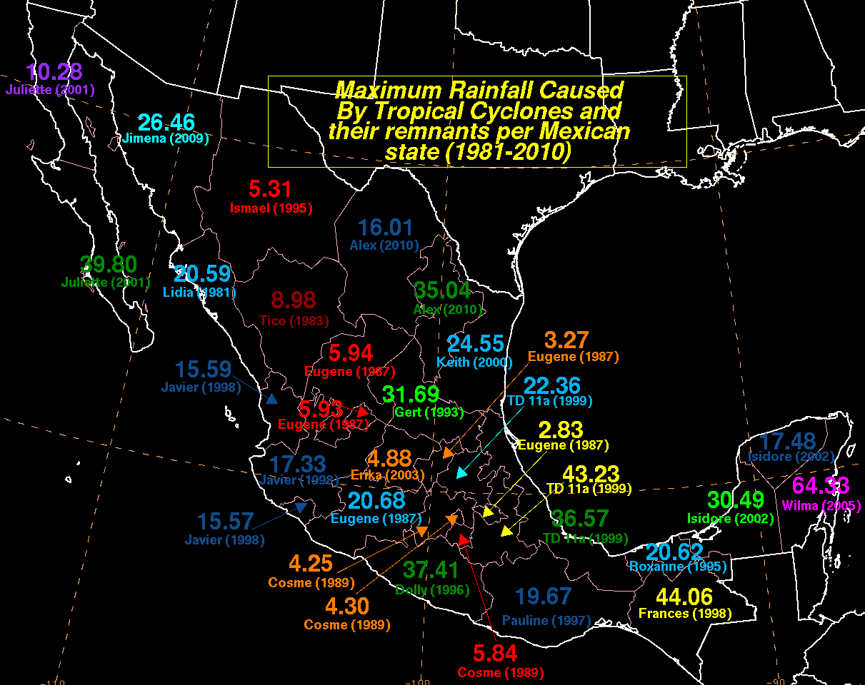
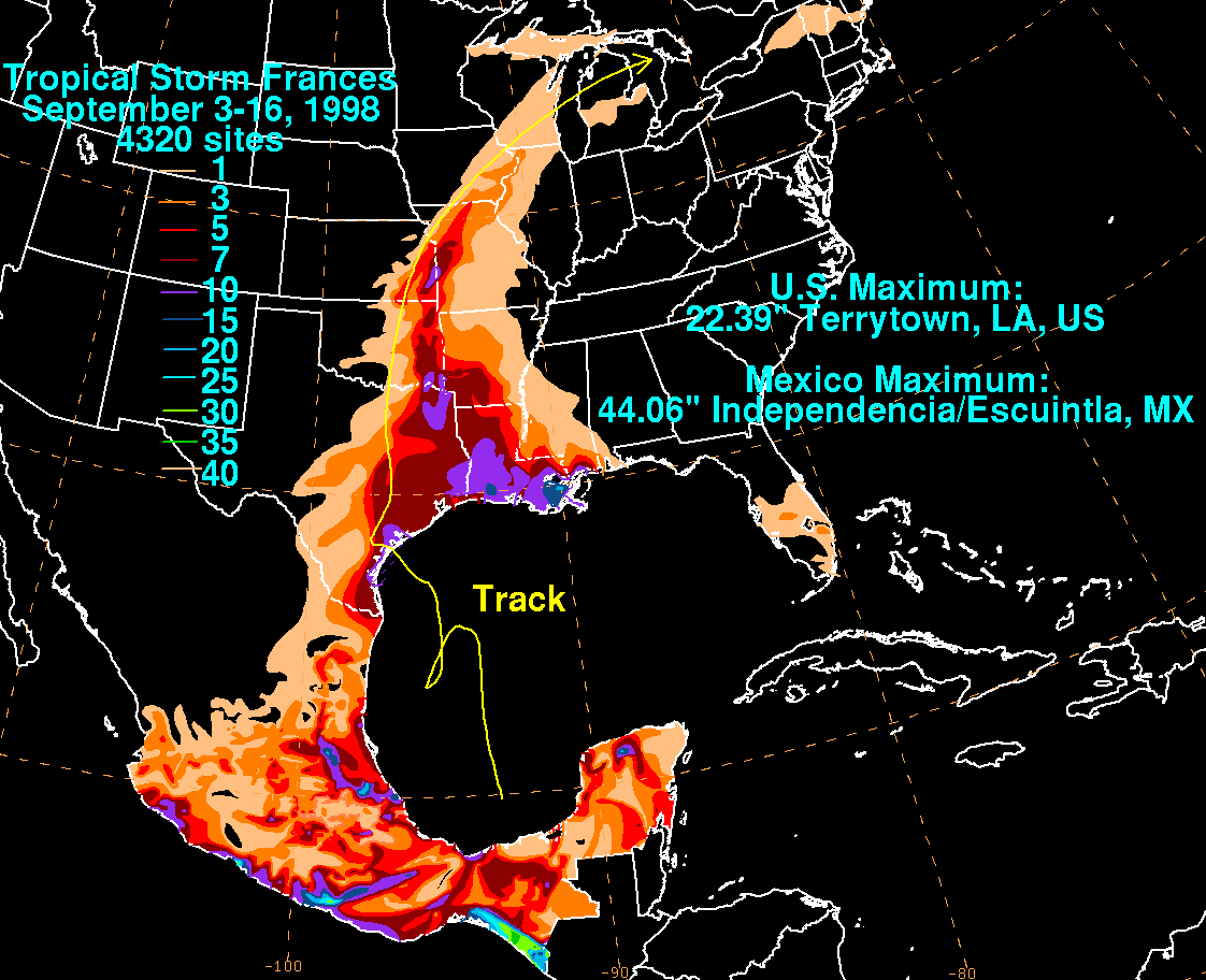
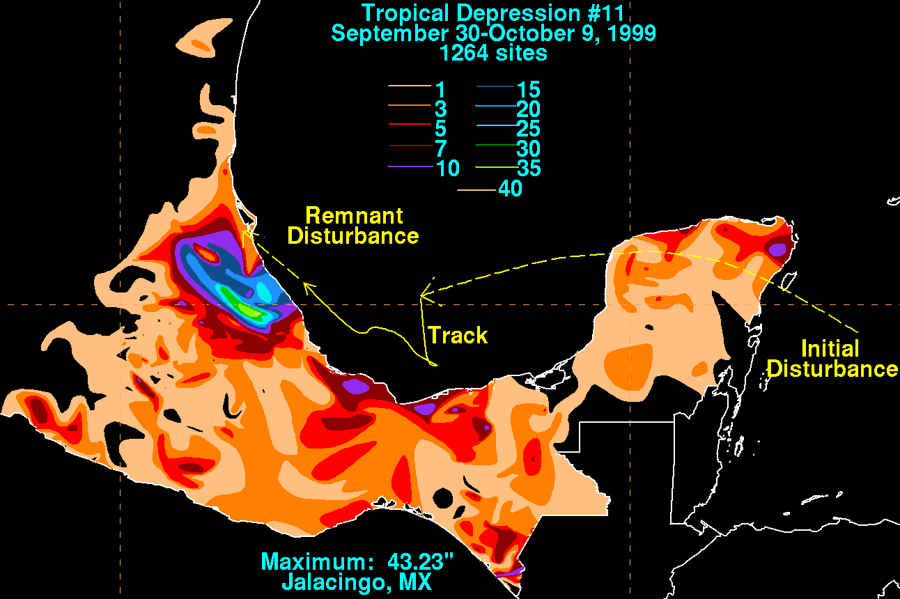
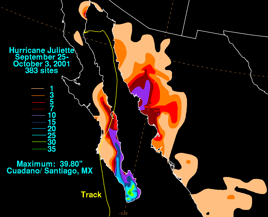
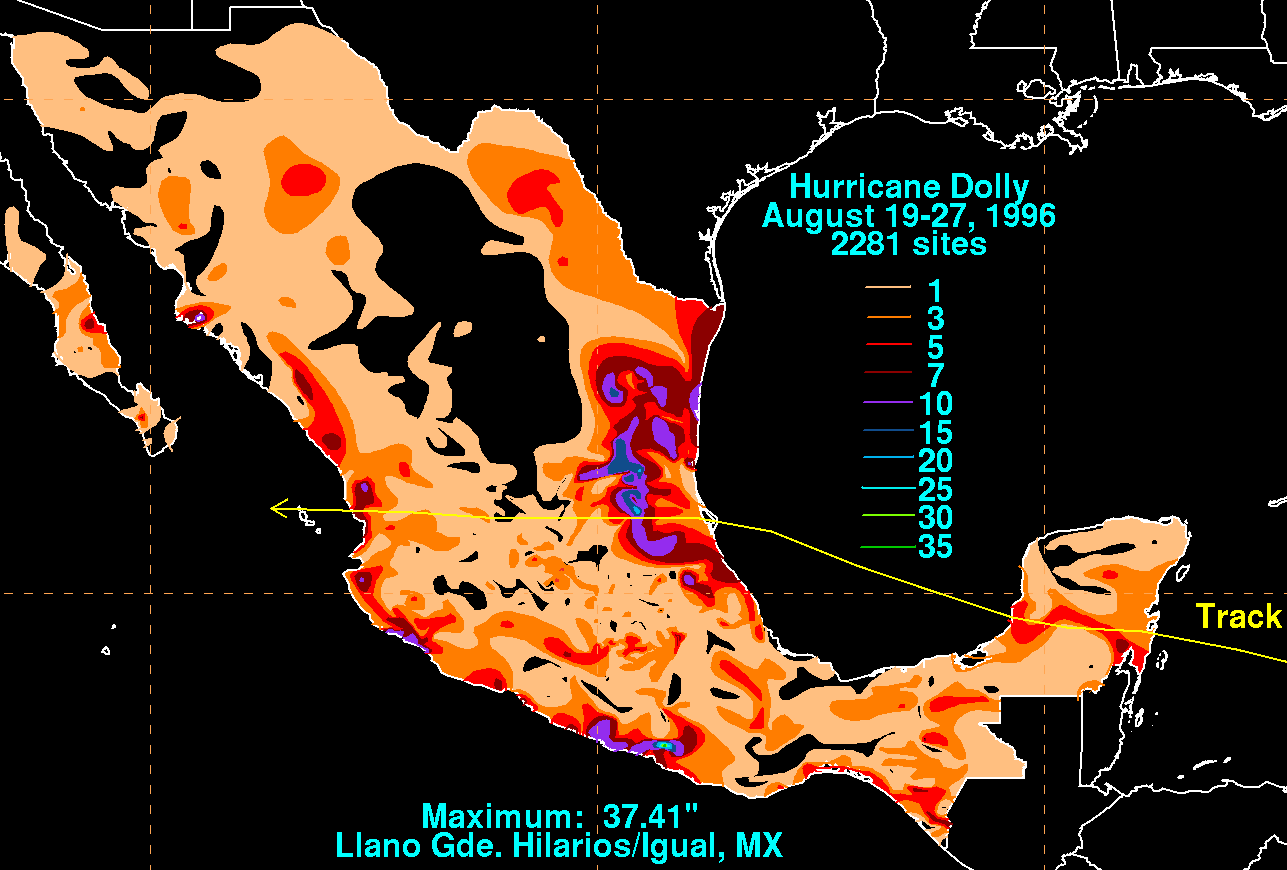
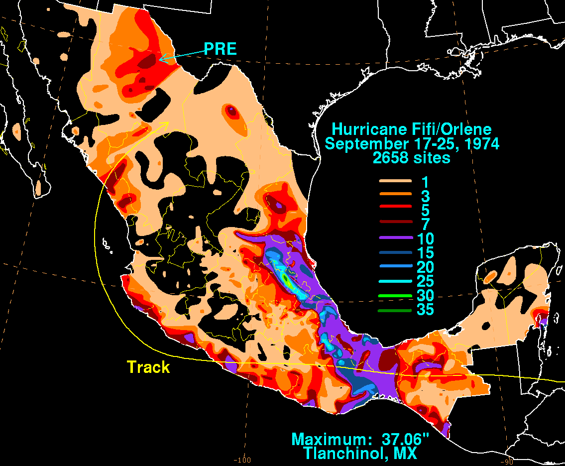
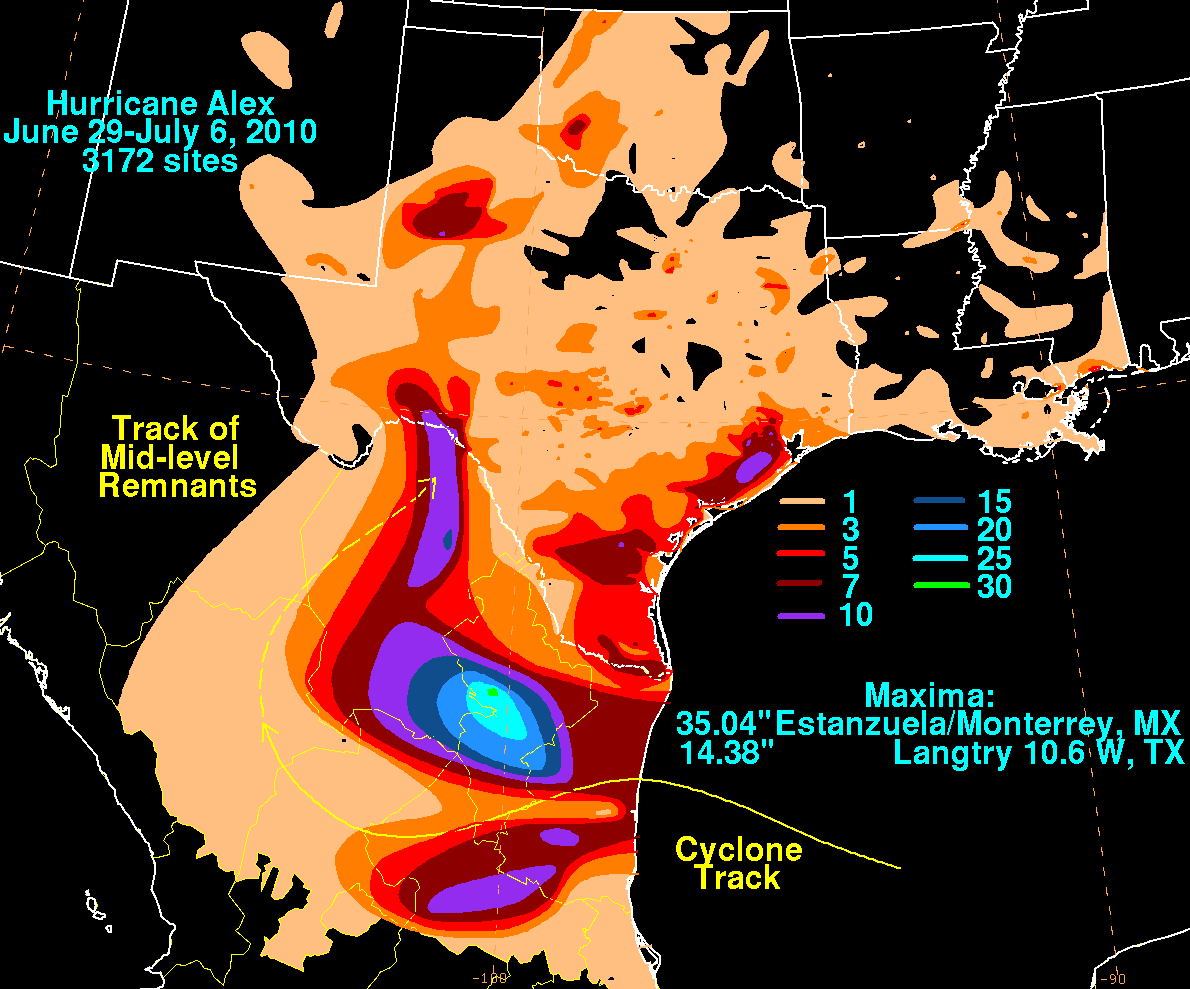
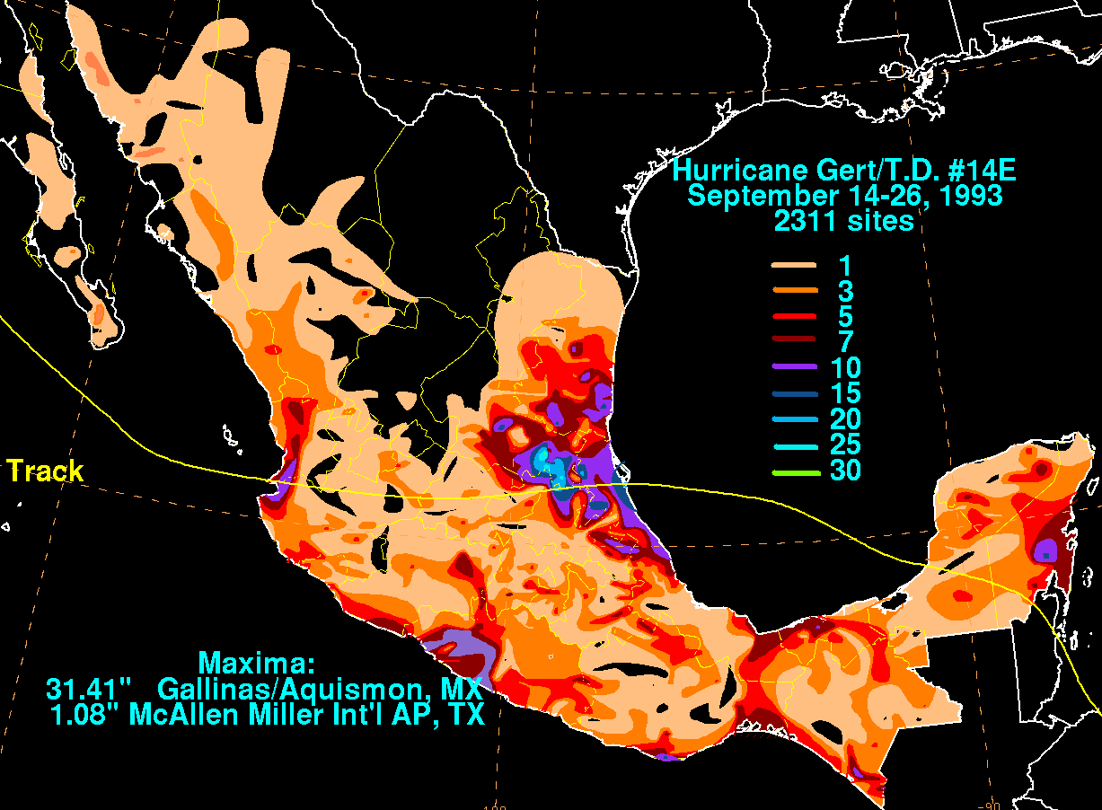
Wettest tropical cyclones and their remnants Mexico (Overall) Highest-known totals
Over 250mm (10in) of rain fell across parts of Guerrero and Oaxaca within the first few hours after John's landfall.[37] Over 500mm (20in) of rain fell in Acapulco.[38] In total, John dropped 1,442mm (56.8in) of rain in Guerrero, five times the amount that fell during Otis's passage the previous year; 19 neighborhoods were left completely underwater, and over 2,000 homes were flooded.[39][40] Some local regions along John's path received 80% of their typical yearly rainfall from the storm.[41][42] Torrential rains also fell across the neighboring states of Chiapas, Veracruz, Michoacán and Puebla.[43] The amount of rain dropped by John was considered historic, bringing 214% more water than Hurricane Pauline, which devastated southern Mexico in 1997.[44]
At least 29 people died in the storm: 23 in Guerrero, 5 in Oaxaca, and 1 in Michoacán.[45][46]Governor of GuerreroEvelyn Salgado reported two deaths caused by a landslide in the municipality of Tlacoachistlahuaca.[47] Additionally, a 70-year-old woman was killed in Malinaltepec when a landslide struck her house.[48] Areas along the southwestern Mexican coast experienced mudslides while tin roofs were blown off several houses.[49] At least 80 landslides occurred in Oaxaca, cutting off roads and communities in the state.[50] 13 restaurants collapsed in Acapulco.[45] The small village of El Espinalillo in southern Guerrero was completely cut off from electricity, potable water and communications outside the town.[41] The Mexican federal government's National Civil Protection Coordination rescued 5,120 people from flooded areas in Acapulco.[44]
According to Gallagher Re, as of January 2025, damages for John are at USD$2.45 billion.[61] Following the hurricane, the Mexican Navy activated Plan DN-III-E, a disaster relief and rescue plan, with 25,000 military units deployed to assist residents affected by John.[39] At least 18,728 members of an international relief task force were sent to assist affected residents by the National Civil Protection Coordination. In the Costa Chica and Costa Grande regions, 5,000 people were placed in temporary storm shelters.[44] In Oaxaca, where over 98,000 people lost power, 18,000 armed services members and government workers were deployed to assist in emergency response operations.[37] The World Central Kitchen distributed over 878,000 meals to those impacted by the hurricane.[62] President Claudia Sheinbaum announced a 8 billion pesos (US$400 million) reconstruction aid to rebuilt tourism and improve public services in Acapulco.[54]
Due to the damage and destruction it caused, the name John was retired by the WMO Hurricane Committee on April 2, 2025, and will never be used again for an Eastern Pacific hurricane. It will be replaced by Jake in the 2030 season.[63]
↑ Blake, Eric (September 23, 2024). Tropical Storm John Advisory Number 3 (Report). Miami, Florida: National Hurricane Center. Retrieved September 23, 2024.
↑ Kelly, Larry (September 23, 2024). Hurricane John Discussion Number 7 (Report). Miami, Florida: National Hurricane Center. Retrieved September 23, 2024.
↑ Papin, Philippe (September 23, 2024). Hurricane John Update (Report). Miami, Florida: National Hurricane Center. Retrieved September 23, 2024.
1 2 John Canigalosi; Lisa Bucci (September 24, 2024). Remnants of John Discussion Number 10 (Report). Miami, Florida, United States: National Hurricane Center. Retrieved September 25, 2024.
↑ Lisa Bucci; Robert Zelinsky (September 25, 2024). Tropical Storm John Discussion Number 11 (Report). Miami, Florida, United States: National Hurricane Center. Retrieved September 25, 2024.
↑ Lisa Bucci; Robert Zelinsky (September 25, 2024). Tropical Storm John Discussion Number 12 (Report). Miami, Florida, United States: National Hurricane Center. Retrieved September 28, 2024.
↑ Dave Roberts (September 26, 2024). Tropical Storm John Discussion Number 14 (Report). Miami, Florida, United States: National Hurricane Center. Retrieved September 28, 2024.
↑ Andrew Hagen (September 26, 2024). Tropical Storm John Discussion Number 17 (Report). Miami, Florida, United States: National Hurricane Center. Retrieved September 28, 2024.
↑ Larry Kelly (September 27, 2024). Remnants of John Discussion Number 20 (Report). Miami, Florida, United States: National Hurricane Center. Retrieved September 28, 2024.
↑ Jakubowski, Steve; Krovvidi, Adityam; Podlaha, Adam; Bowen, Steve. "September 2013 Global Catasrophe Recap"(PDF). Aon Benfield. Archived(PDF) from the original on March 3, 2016. Retrieved October 25, 2013.
↑ Beven, Jack (January 10, 2011). Tropical Storm Agatha(PDF) (Report). Tropical Cyclone Report. National Hurricane Center. Retrieved January 14, 2011.
↑ Brad J. Reinhart (February 12, 2024). Hurricane Hilary (EP092023) 16–20 August 2023(PDF) (Tropical Cyclone Report). National Hurricane Center. Archived(PDF) from the original on February 13, 2024. Retrieved June 18, 2024.
This page is based on this Wikipedia article Text is available under the CC BY-SA 4.0 license; additional terms may apply. Images, videos and audio are available under their respective licenses.


!["Precipitación acumulada (mm) del 22 al 28 de septiembre de 2024 por el huracán John [Accumulated precipitation (mm) from September 22 to 28, 2024, due to Hurricane John]"](https://smn.conagua.gob.mx/tools/RESOURCES/com_mapas_lluvias/Huracan-John-final2.jpg)