Tropical storm (39–73 mph, 63–118 km/h)
Category 1 (74–95 mph, 119–153 km/h)
Category 2 (96–110 mph, 154–177 km/h)
Category 3 (111–129 mph, 178–208 km/h)
Category 4 (130–156 mph, 209–251 km/h)
Category 5 (≥157 mph, ≥252 km/h)
Unknown
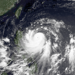
In late-August 1988, increased convective activity was noted along the Intertropical Convergence Zone by forecasters at the Central Pacific Hurricane Center (CPHC). An area of low pressure subsequently developed within this disturbance and was designated as Tropical Depression One-C at 12:00 UTC on August 28. Upon classification, the depression was situated roughly 800 mi (1,300 km) southeast of the Big Island of Hawaii and moving west-northwest. Steady intensification ensued over the following day with the system attaining gale-force winds by 18:00 UTC on August 29, at which time it was assigned the name Uleki. [nb 1] The storm later attained winds of 75 mph (121 km/h) on August 31 and was dubbed a hurricane as it passed 350 mi (560 km) south of Hilo. Thereafter, Uleki underwent a sudden period of rapid intensification and achieved major hurricane status later that day. [nb 2] After reaching this strength, Uleki's forward motion gradually lessened and eventually almost ceased altogether on September 1 as upper-level steering currents collapsed. [2]
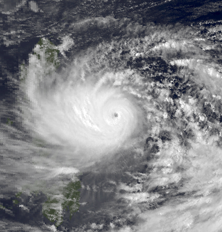
With the hurricane situated to the southwest of the Hawaiian Islands, Hurricane Hunters conducted several weather reconnaissance missions into the storm. On September 2, they found maximum surface winds of 125 mph (201 km/h) and a minimum barometric pressure of 957 mbar (hPa; 28.26 inHg); this corresponded to the peak intensity of Uleki. [2] At the time, Uleki displayed a well-organized, tight circulation. [1] The hurricane meandered in the same general area over the next two days, executing several small loops, with a slight northward drift. [2] During this time, its circulation increased in coverage but became less-organized as weakening ensued. [1] Increased wind shear and restricted outflow took their toll on the hurricane. [3] The cyclone's winds dropped to 80 mph (130 km/h) by 12:00 UTC on September 4 as it resumed its west-northwest track under the influence of a subtropical ridge away from the Hawaiian Islands. [2] [3] Uleki passed roughly halfway between Johnston Atoll and the French Frigate Shoals on September 5. By September 7, the weakened trend halted and environmental conditions favored reintensification. As Uleki neared the International Date Line, it regained winds of 105 mph (169 km/h). [2]

At 00:00 UTC on September 8, the CPHC transferred warning responsibility of Uleki to the Joint Typhoon Warning Center (JTWC) and the storm was subsequently referred to as a typhoon. Transfer of warnings occurred when the storm was at 178°W rather than at the dateline, where the boundary between the Central and West Pacific basins exists, for unknown reasons. Three hours later Uleki made its closest approach to Midway Atoll, passing 200 mi (320 km) to the south. Shortly thereafter the system crossed the International Date Line and the Japan Meteorological Agency (JMA) also began advising on the system. [2] [4] The JMA estimated Uleki to have had a pressure of 945 mbar (945 hPa; 27.9 inHg) at this time; however, this value was derived from satellite estimates rather than direct measurements. [4] Uleki maintained this strength through September 10 as it continued on its west-northwest course. On that day, the typhoon again entered a region of weak steering currents between two anticyclones within the subtropical ridge. A trough approaching from the west was forecast to prompt Uleki to turn east; however, the typhoon maintained a general northwest motion in a stair-stepped fashion. Increasing wind shear and cooler air soon imparted weakening, [3] and Uleki degraded to a tropical storm by September 12. [4]
Continued effects from shear stripped the cyclone of all deep convection, and by September 14 only a band of cirrus clouds remained in association with Uleki. The JTWC issued their final warning on the system at 00:00 UTC that day accordingly. [3] The JMA maintained the system as a tropical depression as the former typhoon began turning to the east. Uleki later transitioned into an extratropical cyclone on September 16 as it accelerated to the east. The system dissipated the following day near the International Date Line, far from any major landmasses. [4]
Preparations and impact
As the hurricane stalled to the southwest of Hawaii on September 3, tropical storm watches were issued for Oahu, Kauai, and Niihau. High surf advisories were raised for all islands as well. [1] Following Uleki's turn to the west on September 5, the tropical storm watches were discontinued. [5] The storm's erratic movement proved to be troublesome for forecasters and they continuously warned residents to be cautious and alert should the storm double-back to the state. On September 4, lifeguards at Waikiki Beach and Ala Moana Beach rescued 19 people caught in 5 to 6 ft (1.5 to 1.8 m) swells. Further north in Oahu, two people drowned after being caught in rough waters. [2] [6]
The storm moved roughly halfway between the French Frigate Shoals and Johnston Island on September 5 with no adverse effects in either region due to its weakened state. [2] On September 7, the 300 residents of Midway Atoll and United States Coast Guard personnel stationed on Kure Atoll prepared for possible hurricane-force winds from the storm. [7] Hurricane Uleki ultimately passed 200 mi (320 km) south of Midway Atoll and produced some coastal flooding from increased surf. Some breaking waves spilled onto the runway at Henderson Field. [2]
See also
- List of Hawaii hurricanes
- 1988 Pacific hurricane season
- Hurricane Keoni (1993) – A similarly long-lasting and intense hurricane that also took a similar track
- Hurricane Kilo (2015) – Took a similar track and had a similar peak intensity
Notes
- ↑ Uleki is the Hawaiian name for Ulysses. [1]
- ↑ A major hurricane is a storm with sustained winds of 111 mph (179 km/h) or higher, equivalent to a Category 3 or greater on the Saffir–Simpson hurricane wind scale.
Related Research Articles

The 1988 Pacific typhoon season had no official bounds; it ran year-round in 1988, but most tropical cyclones tend to form in the northwestern Pacific Ocean between May and November. These dates conventionally delimit the period of each year when most tropical cyclones form in the northwestern Pacific Ocean. Tropical Storms formed in the entire west Pacific basin were assigned a name by the Joint Typhoon Warning Center. Tropical depressions that enter or form in the Philippine area of responsibility are assigned a name by the Philippine Atmospheric, Geophysical and Astronomical Services Administration or PAGASA. This can often result in the same storm having two names.
Typhoon Dot, known in the Philippines as Typhoon Saling, was the strongest storm of the 1985 season. Dot originated from a small area of thunderstorm activity in early to mid October. The system was first classified on October 11, and steadily intensified over the next few days. Dot attained typhoon strength on October 15, and subsequently entered a period of explosive deepening, which was not anticipated by forecasters. The next day the intensification rate slowed, but that evening, Dot attained its maximum intensify. A steady weakening trend began on October 17, though the system maintained typhoon intensity through the passage of the Philippines. After entering the South China Sea late on October 18, Dot briefly re-intensified, only to weaken as it approached Vietnam. On October 21, Dot struck Vietnam while still a typhoon, but dissipated the next day over the high terrain of the nation.

Typhoon Alex, known in the Philippines as Typhoon Etang, affected the Taiwan, China, and South Korea during July 1987. Typhoon Alex developed from the monsoon trough that spawned a tropical disturbance late on July 21 southwest of Guam which organized into a tropical depression shortly thereafter. The system steadily became better organized, and the next day, a tropical depression had developed. Satellite intensity estimates gradually increased, and on July 23, the depression intensified into Tropical Storm Alex. After initially tracking west-northwest, Tropical Storm Alex started tracking northwest. An eye developed on July 24, and on the next day, Alex was classified as a typhoon, when Alex attained its peak intensity of 120 km/h (75 mph) and a minimum barometric pressure of 970 mbar (29 inHg). Alex weakened while tracking more northward, though interaction with Taiwan resulted in a more westward track starting on July 27. The storm struck near Shanghai as a tropical storm, and weakened over land, although it remained identifiable through August 2.
Typhoon Cecil, known in the Philippines as Typhoon Loleng, was a mid-season tropical cyclone that affected Japan and South Korea during August 1982. An area of disturbed weather formed to the north of Truk on July 31 and tracked westward over the next several days. Following an increase in shower activity and a decrease in wind shear, a tropical depression developed on August 4. Two days later, the depression strengthened into a tropical storm. After turning northwestward and then northward, Cecil intensified into a typhoon on August 7, and then began to deepen at a rapid clip. On August 8, Cecil attained its maximum intensity as it brushed Taiwan. There, 19 people were killed, including 4 in Wugu District, where 2,800 families sought shelter. After pulling away from Taiwan, Typhoon Cecil moved northwestward, and then on August 10, turned to the north-northeast. Colder air, cooler waters, and higher shear contributed to a weakening trend, and Cecil was downgraded to a tropical storm on August 11. Although Cecil passed east of Japan, it came close enough to the country to drop heavy rains. Nation-wide, three people were killed and two were injured. A total of 2,100 households lost power in Hinokage. On August 14, Cecil turned east and struck South Korea as a minimal tropical storm before dissipating over the Sea of Japan. Throughout South Korea, 35 people were killed, 28 went missing, and 28 others sustained injuries. Almost 1,300 houses were flooded, which resulted in 6,200 people becoming homeless. Damage was estimated at US$30 million.

Typhoon Cecil, known in the Philippines as Tropical Storm Rubing, was one of two typhoons to strike Vietnam within a week in 1985. Cecil originated from an area of convection that tracked west-northwest and passed south of Palau late on October 9. The disturbance became increasingly defined as it moved through the southern Philippines. On October 12, a tropical depression developed, and the next day, the depression was upgraded into a tropical storm. Cecil turned northwest over the open waters of the South China Sea as it steadily strengthened, and was classified as a typhoon on October 14. After unexpectedly slowing down, Cecil continued to intensify and at noon of October 14, reached its peak intensity of 145 km/h (90 mph). Land interaction with Vietnam triggered a weakening trend. After turning west, Cecil moved onshore just north of Huế at 22:00 UTC on October 15. After tracking into Laos, the typhoon dissipated 39 hours later.

Typhoon Clara, known in the Philippines as Typhoon Rubing, left flooding in the northern Philippines and southern China during September 1981. An area of disturbed weather was first detected on September 11 near Ponape. After moving westward, the system gradually became better organized and thunderstorm activity increased. On September 16, the system attained tropical storm status. Two days later, Clara attained typhoon intensity and subsequently began to deepen at a faster rate. On September 19, Clara reached maximum intensity, before making landfall along the northern tip of Luzon. Clara steadily weakened after interacting with land, but by late on September 20, Clara leveled off in intensity over the South China Sea. The next day, Clara moved ashore to the east-northeast of Hong Kong while still at typhoon intensity before rapidly dissipating over land.

Typhoon Ken, known in the Philippines as Typhoon Tering, was the fourth typhoon to strike Japan during the 1982 Pacific typhoon season. Forming along the western end of the monsoon trough in the Philippine Sea, the system had organized into a tropical depression on September 16, and by that night a tropical storm. As a compact system, rapid intensification continued, with Ken becoming a typhoon on the evening of September 17 and a major typhoon on September 18. The cyclone up to this point had a history of progressing slowly west-northwest, but Ken eventually stalled on September 20 and became a larger cyclone. As a mid-latitude trough to its north deepened, Ken took off to the northeast towards Okinawa. Ken made landfall upon Shikoku early on September 25, and moved onward into the Sea of Japan where it evolved into an extratropical cyclone. Five people were killed while 18 others were hurt. A total of 114 mudslides were reported, resulted in over 2,000 homes flooded. Additionally, 12 homes were damaged or destroyed. Seventy-four flights were cancelled as well.

Severe Tropical Storm Tess known in the Philippines as Tropical Storm Welpring was the second of three tropical cyclones to directly impact the Philippines in a two-week time frame in 1988. An area of disturbed weather near the Philippines was first observed on November 1. Following an increase in organization, the disturbance was designated as a tropical cyclone on November 4. Moving west, Tess steadily strengthened due to favorable conditions aloft. During the evening of November 5, Tess was estimated to have achieved its highest intensity, with winds of 115 km/h (70 mph). Rapid weakening then ensured as Tess neared Vietnam, and after making landfall in the country on November 6, Tess dissipated the next day.

Hurricane Genevieve, also referred to as Typhoon Genevieve, was the first tropical cyclone to track across all three northern Pacific basins since Hurricane Dora in 1999. Genevieve developed from a tropical wave into the eighth tropical storm of the 2014 Pacific hurricane season well east-southeast of Hawaii on July 25. However, increased vertical wind shear caused it to weaken into a tropical depression by the following day and degenerate into a remnant low on July 28. Late on July 29, the system regenerated into a tropical depression, but it weakened into a remnant low again on July 31, owing to vertical wind shear and dry air.

Typhoon Kim, known in the Philippines as Typhoon Osang, was the second typhoon in a week to directly affect the Philippines during July 1980. Like Typhoon Joe, Kim formed from the near equatorial monsoon trough in the northwestern Pacific Ocean on July 19. The disturbance tracked quickly westward-northwest underneath a subtropical ridge, reaching tropical storm strength on the July 21 and typhoon strength on July 23. After developing an eye, Kim began to rapidly intensify, and during the afternoon of July 24, peaked in intensity as a super typhoon. Several hours later, Kim made landfall over the Philippines, but the storm had weakened considerably by this time. Throughout the Philippines, 40 people were killed, 2 via drownings, and 19,000 others were directly affected. A total of 12,000 homes were destroyed and 5,000 villages were flooded. Less than a week earlier, the same areas were affected by Joe; however, Kim was considered the more damaging of the two typhoons. Land interaction took its toll on Kim, and upon entering the South China Sea, the storm was down below typhoon intensity. Kim continued northwestward but its disrupted circulation prevented re-intensification, and it remained a tropical storm until hitting southern China July 27 to the northeast of Hong Kong, where only slight damage was reported. Later that day, Kim dissipated.

Typhoon Gerald, known in the Philippines as Typhoon Neneng, affected the Philippines, Taiwan, and China during September 1987. A tropical depression developed on September 4, and within 24 hours, intensified into a tropical storm. After initially moving erratically within the Philippine Sea, Gerald moved west-northwest and then northwest while steadily deepening. Gerald obtained typhoon intensity on September 8, and the following day, attained maximum intensity. Shortly thereafter, the typhoon skirted southwestern Taiwan, which resulted in a steady weakening trend. On September 10, Gerald moved ashore north of Hong Kong near Amoy. Gerald dissipated the next day.
Typhoon Dinah, known as Typhoon Luding in the Philippines, was the costliest tropical cyclone to form in the 1987 Pacific typhoon season. It also was the fourth typhoon to form during August 1987. An area of low pressure developed near Guam on August 19, and two days later, the low reached tropical storm intensity as it moved generally west. Intensification was initially gradual, with Dinah becoming a typhoon early on August 24, before it subsequently intensified at a faster pace. Dinah reached its highest strength on August 26 before turning northward on August 28 and into a less favorable conditions aloft, which prompted weakening. Dinah entered the Sea of Japan after passing near Okinawa on August 29, where Dinah leveled off in intensity. The system then began to recurve towards southwestern Japan, and after tracking through the area, Dinah transitioned into an extratropical cyclone on August 31, although the remnants could be traced for four more days as it approached the International Date Line.

Typhoon Cary, known as Typhoon Ising in the Philippines, was the second of two tropical cyclones to affect Vietnam in a week. An area of disturbed weather developed southwest of Pohnpei on August 6, 1987. The system initially remained disorganized, but by August 14, Cary had attained tropical storm intensity. After initially moving north-northwest, Cary turned west-northwest, although intensification was slow to occur. On August 15, Cary was upgraded into a typhoon, and on August 17, the typhoon peaked in intensity. Typhoon Cary then made landfall in northern Luzon while at peak intensity. Across the Philippines, 954 houses were damaged and an additional 89 were destroyed, which left 55,567 people, or 13,247 families that were either homeless or otherwise sought shelter. Five people died in the country while damage totaled $5.58 million (1987 USD), including $1.45 million from agriculture and $4.13 million from infrastructure. The storm weakened over land, but re-intensified into a typhoon over the South China Sea. On August 21, Typhoon Cary passed just south of Hainan, where hundreds of homes were damaged but no fatalities occurred, and subsequently entered the Gulf of Tonkin. The storm weakened as it approached Vietnam, and on August 23, the storm dissipated inland over Laos. Across Vietnam, almost 40,000 ha of land were flooded or destroyed. Twenty people were killed and many others were injured.

Typhoon Abby, known as Typhoon Norming in the Philippines, was the second typhoon to affect Taiwan in a month during September 1986. A tropical depression developed on September 13 and the next day attained tropical storm status, upon which it was named Abby. Continuing to intensify, Abby moved west-northwest and became a typhoon on September 16. Two days later, the typhoon attained maximum intensity. On September 19, the typhoon made landfall in Taiwan as it turned towards the northwest. Rapid weakening occurred due to land interaction, and on September 20, Typhoon Abby transitioned into an extratropical cyclone. Its extratropical remnants were last noted on September 24 as they raced off to the northeast.

Typhoon Joe, known in the Philippines as Typhoon Nitang, affected the Philippines, China, and Vietnam during July 1980. An area of disturbed weather formed near the Caroline Islands on July 14. Shower activity gradually became better organized, and two days later, the system was upgraded into a tropical depression. On July 18, the depression was classified as Tropical Storm Joe. Initially, Joe moved northwest, but began to turn to the west-northwest, anchored by a subtropical ridge to its north. Joe started to deepen at a faster clip, and attained typhoon intensity on July 19. The eye began to clear out, and the next day, Joe reached its highest intensity. Shortly thereafter, Joe moved ashore the Philippines. There, 31 people were killed and 300,000 others were directly affected. Around 5,000 homes were destroyed, resulting in an additional 29,000 homeless. Damage in the nation was estimated at $14.5 million (1980 USD).
Typhoon Betty, known in the Philippines as Typhoon Aring, was the strongest typhoon to strike the Philippines in ten years. An area of disturbed weather developed on October 27, 1980, near Truk Atoll. After turning east from south, the disturbance was classified as a tropical storm on October 29 as it passed near Guam, causing only minor damage. Following a turn to the west-northwest, Betty attained typhoon intensity the next day. On November 4, Betty peaked in intensity. Later that day, Betty moved ashore over Luzon, introducing a rapid weakening trend. Over land, Betty then began to turn north due to a weakening subtropical ridge to its north and a trough offshore Taiwan. By November 8, Betty, after moving offshore, had completed its transition into an extratropical cyclone, and dissipated that same day.

Typhoon Irving, known in the Philippines as Tropical Storm Ruping, was a mid-season tropical cyclone that affected the Philippines and China during September 1982. An area of disturbed weather developed within the monsoon trough during early September 1982 near Guam. Following an increase in organization, a tropical depression developed on the morning of September 5. Later that day, the depression intensified into Tropical Storm Irving. Irving tracked westward, nearly becoming a typhoon before hitting the central Philippines. There, Irving uprooted trees, downed power and telephone lines, triggered landslides, and forced the cancellation of several domestic airline flights. Irving damaged 7,890 houses in Albay and Sorsogon provinces alone, resulting in 138,500 people homeless. Nation-wide, 65 people were killed, 26 others were hurt, and 29 were rendered missing. A total of 44,383 families or 248,040 residents sought shelter. Moreover, 18,488 homes were damaged and 5,599 others were demolished. Damage in the country was assessed at US$23.3 million, including US$14.2 million in crops. While crossing the island chain, Irving turned northwestward. After entering the South China Sea, Irving continued generally northwest, and became a typhoon on September 11. After developing a well-defined eye, Irving attained its peak intensity of 160 km/h (100 mph) the following day. Land interaction with Hainan Island resulted in a weakening trend, and Irving was downgraded to a tropical storm before striking the southern coast of China on September 15. Across the Leizhou Peninsula, 90% of homes were damaged. Onshore, Irving rapidly weakened and the storm dissipated on September 16.

Typhoon Holly, known in the Philippines as Typhoon Isang, affected South Korea, Japan, and the Soviet Union during August 1984. Holly originated from the monsoon trough that extended eastward from its original position in mid-August 1984. Over a period of several days, the system slowly became better organized as it tracked westward, although the system did not initially develop a well-defined center. On August 15, a tropical depression was declared, and on the next day, the depression was upgraded into Tropical Storm Holly. Holly slowly gained strength, becoming a typhoon on August 17 as it passed near Okinawa. The typhoon turned northwest and then north as it rounded a subtropical ridge. At noon on August 19, Holly attained its peak intensity of 130 km/h (80 mph). Shortly after its peak, Holly accelerated northeast due to the westerlies in the general direction of the Korean Peninsula. Land interaction with South Korea triggered a weakening trend, and after entering the Sea of Japan, Holly began to transition into an extratropical cyclone. Thunderstorm activity quickly decreased near the center, and by August 21, Holly had completed its extratropical transition.
Typhoon Warren, known in the Philippines as Typhoon Huaning, struck the Philippines and China during July 1988. An area of disturbed weather developed within the vicinity of the Caroline Islands during the second week of July. A tropical depression developed southeast of Guam on July 12, and on the next day, intensified into a tropical storm. Tracking generally west-northwest, Warren deepened into a typhoon on July 14. The storm subsequently entered a period of rapid intensification, commencing with Warren reaching its highest intensity on July 16. The following evening, the typhoon brushed Luzon, resulting in a weakening trend, although Warren was still a typhoon when it made landfall near Shantou. Warren rapidly dissipated inland.

Typhoon Percy, known in the Philippines as Typhoon Klaring, was the third tropical cyclone to affect the country in 1990. The fourth and the last tropical cyclone to be formed in June of the 1990 Pacific typhoon season, Typhoon Percy originated from an area of disturbed weather spawned by the Western Pacific monsoon trough on June 20. That same day, the disturbance was classified as a tropical depression as it slowly organized and on June 21, the depression obtained tropical storm intensity. After initially tracking westward, Percy turned towards the southwest while slowly deepening. During this time, Percy affected several of the Carolina Islands. Thirty homes were damaged and airline services were halted in and out of Yap. Farther south-southwest, seven homes were destroyed on the Ngulu Atoll. Furthermore, one boy was killed on Koror, where numerous homes lost their roofs and communication lines were downed. Percy then turned back to the west-northwest and became a typhoon on June 23. It then began to deepen at a faster rate, with Percy attaining its maximum intensity of 145 km/h (90 mph) on June 25. Two days later, on June 27, increased wind shear began to induce a weakening trend and the typhoon brushed Luzon, where eight people were killed and over 30,000 lost their homes. Despite that however, damages in the country was minor.
References
- 1 2 3 4 "Powerful Hurricane Plays Waiting Game With Hawaii". Honolulu, Hawaii. Associated Press. September 3, 1988. – via Lexis Nexis (subscription required)
- 1 2 3 4 5 6 7 8 9 "August 28-September 7, 1988 (Hurricane Uleki)". The 1988 Central Pacific Tropical Cyclone Season. Central Pacific Hurricane Center (Report). Honolulu, Hawaii: National Oceanic and Atmospheric Administration. 2014. Archived from the original on September 29, 2018. Retrieved June 30, 2019.
- 1 2 3 4 Cpt. John M. Rogers and Lt. Douglas H. Scovil Jr. (1989). "Typhoon Uleki (01C)" (PDF). Annual Tropical Cyclone Report. Joint Typhoon Warning Center (Report). United States Navy. pp. 88–91. Retrieved August 20, 2014.
- 1 2 3 4 "Typhoon 198817 (ULEKI) – Detailed Track Information". Japan Meteorological Agency. National Institute of Informatics. 1989. Retrieved August 20, 2014.
- ↑ "Forecasters Say Hurricane Winds No Longer Pose Threat to Hawaii". Honolulu, Hawaii. Associated Press. September 5, 1988. – via Lexis Nexis (subscription required)
- ↑ Bruce Dunford (September 3, 1988). "Hurricane Near Hawaii Weakens, Easing Threat". Honolulu, Hawaii. Associated Press. – via Lexis Nexis (subscription required)
- ↑ Bruce Dunford (September 7, 1988). "Hurricane Uleki Threatens Midway Island, Kure Atoll". Honolulu, Hawaii. Associated Press. – via Lexis Nexis (subscription required)
 Hurricane Uleki at peak intensity southwest of the Hawaiian Islands on September 3 |
Tropical cyclones of the 1988 Pacific hurricane season | ||
|---|---|---|
 | ||