Related Research Articles

The 2007 South Asian floods were a series of floods in India,Pakistan,Bhutan,Nepal and Bangladesh. News Agencies,citing the Indian and Bangladeshi governments,place the death toll in excess of 2,000. By 3 August,approximately 20 million had been affected and by 10 August some 30 million people in India,Bangladesh and Nepal had been affected by flooding.
The 2008 Indian floods were a series of floods in various states of India during the 2008 monsoon season. The floods mostly affected the western regions of Maharashtra state and Andhra Pradesh as well as northern Bihar. In India,the monsoon season generally lasts from June to September.
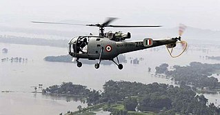
The 2008 Bihar flood was one of the most disastrous floods in the history of Bihar,an impoverished and densely populated state in India. The Koshi embankment near the Indo-Nepal border broke on 18 August 2008. The river changed course and flooded areas which had not been flooded in many decades. The flood affected over 2.3 million people in the northern part of Bihar.
Bihar is India's most flood-prone state,with 76% of the population of North Bihar living under the recurring threat of devastating flooding. Bihar makes up 16.5% of India's flood-affected area and contains 22.1% of India's flood-affected population. About 73.06% of Bihar's geographical area,68,800 square kilometres (26,600 sq mi) out of 94,160 square kilometres (36,360 sq mi),is affected. Each year,floods kill many and damage livestock and other assets worth millions. In total,floods have claimed 9,500 lives since the government started publishing figures in 1979. North Bihar districts are vulnerable to at least five major flood-causing rivers during monsoon –the Mahananda,Koshi,Bagmati,Burhi Gandak,and Gandak rivers –which originate in Nepal. Some South Bihar districts have also become vulnerable to floods,from the Son,Punpun,and Phalgu rivers. The 2013 flood affected over 5.9 million people in 3,768 villages in 20 districts in the state. The 2017 flood affected 19 districts in North Bihar,killing 514 people and affecting over 17 million.

Severe Cyclonic Storm Aila was the second named tropical cyclone of the 2009 North Indian Ocean cyclone season. Warned by both the Regional Specialized Meteorological Center (RMSC) and Joint Typhoon Warning Center (JTWC),Aila formed over a disturbance over the Bay of Bengal on May 23,2009 and started to intensify and organize reaching sustained wind speeds of 110 kmh (70 mph). It was the worst natural disaster to affect Bangladesh since Cyclone Sidr in November 2007. A relatively strong tropical cyclone,it caused extensive damage in India and Bangladesh.
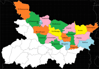
North Bihar is a term used for the region of Bihar,India,which lies north of the Ganga river.

In September 2014,the Kashmir region suffered disastrous floods across many of its districts caused by torrential rainfall. The Indian state of Jammu and Kashmir,as well as the Pakistani territories of Azad Kashmir,Gilgit-Baltistan and the province of Punjab were affected by these floods. By 24 September 2014,nearly 277 people in India and about 280 people in Pakistan had died due to the floods.
This is a list of notable recorded floods that have occurred in India. Floods are the most common natural disaster in India. The heaviest southwest,the Brahmaputra,and other rivers to distend their banks,often flooding surrounding areas.

Deep Depression ARB 02 was a weak tropical cyclone which brought heavy rains and flooding to the Indian state of Gujarat in June 2015. It was the third tropical cyclone and second deep depression of the 2015 North Indian Ocean cyclone season.
Following heavy rain in July 2017,the Indian state of Gujarat was affected by severe flooding. The floods were reported to have caused total 224 deaths between 1 June and 31 July 2017. 16 people had died in neighbouring Rajasthan state by 31 July.

Following heavy rain in July and August 2017,the Indian state of West Bengal was affected by severe flooding. The floods were reported to have caused 50 deaths since 1 August and 8 deaths in the neighbouring state of Jharkhand.

2017 Bihar floods affected 19 districts of North Bihar causing death of 514 people. 2,371 panchayats under 187 blocks of 19 districts of Northern Bihar have been affected in the flood. Around 1.71 crore people were hit by the floods. Over 8.5 lakhs of people have lost their homes,with Araria district alone accounting for 2.2 lakh homeless people. 2017 Flood has broken 9-Year record of deaths In Bihar. Bihar is India's most flood-prone State,with 76% of the population in the North Bihar living under the recurring threat of flood devastation. Devastating flood was caused due to excess heavy rainfall in monsoon season.
The Brahmaputra floods refers to a catastrophic flood event that occurred in 2012 along the Brahmaputra River and its tributaries,as well as in subsequent years.
The 2019 Bihar floods affected 13 districts of North Bihar,India,causing 130 deaths by the end of July. 1269 panchayats under 92 blocks of 13 districts of Northern Bihar were severely affected in the flood. Around 88.46 lakhs people were affected.
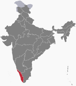
On 8 August 2019,due to heavy rainfall in the monsoon season,severe flood affected Kerala. As a security measure in the prevailing situation of heavy rains,the India Meteorological Department had issued a red alert in the 9 districts in Northern and Central Kerala,orange alert in 3 districts of Central Kerala,and yellow alert in the 2 districts of southern Kerala. Thousands of people have been evacuated to safer places and relief camps. A total of 121 people have died due to rain-related incidents as of 19 August 2019.
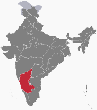
The 2019 Indian floods were a series of floods that affected over thirteen states in late July and early August 2019,due to excessive rains. At least 200 people died and about a million people were displaced. Karnataka and Maharashtra were the most severely affected states. People died but many were rescued with the help of the Indian Navy.
On 1 August 2019,first week,due to heavy rainfall in the Monsoon season,severe flood affected the southern Indian State of Karnataka. As a security measure in the prevailing situation of heavy rains,India Meteorological Department issued Red alert to several regions of coastal and malnad regions of Karnataka state.
Beginning in May 2022,deadly floods hit north eastern India and Bangladesh. Over 9 million people in both countries have been affected,and around 300 people have been killed.
From January to October 2022,excessive rainfall and widespread monsoon flooding occurred in the South Asian countries of Afghanistan,Bangladesh,India,Nepal,Pakistan,and Sri Lanka. It has become the region's deadliest floods since 2020,with over 3,700 people dead.
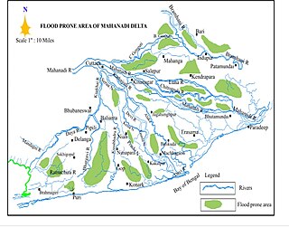
The 2022 Odisha floods were a series of floods in Odisha,which lasted from 14 August 2022 to 7 September 2022.
References
- ↑ "Floods: Helpless Bihar seeks PM's help".
- ↑ A CASE STUDY INTO THE BAGMATI FLOOD FORECASTING IN NORTH BIHAR, https://swat.tamu.edu/media/114999/f2_1_sharan.pdf
- ↑ "North India inundated". Hindustan Times . 3 August 2007. Archived from the original on 5 February 2008. Retrieved 23 November 2008. Last accessed 3 August 2007.
- ↑ "Hunger, disease stalk children hit by South Asia floods". Reuters. 8 August 2007. Retrieved 15 August 2007.
- ↑ "Bangladeshi hospital struggles to cope with flood victims". Reuters. 10 August 2007. Retrieved 15 August 2007.
- ↑ "Flood victims clash with police in India, 30 hurt". Reuters. 11 August 2007. Retrieved 15 August 2007.
- ↑ "Bihar's scary new flood".
- ↑ Jason Motlagh, "Floods devastate northern India state 20 million people affected and 4,000 die – officials blame onset of climate change", Chronicle Foreign Service, 5 October 2007, "Flooding has submerged more than 40 percent of Bihar, and Relief Commissioner R. Srivastava, citing government figures, said rainfall in July was five times higher than the monthly average over a 30-year span."
- 1 2 "Archived copy" (PDF). Archived from the original (PDF) on 21 August 2008. Retrieved 25 November 2008.
{{cite web}}: CS1 maint: archived copy as title (link) - ↑ Indian, The Logical (10 November 2015). "[Watch/Read] Displaced in 2007, Waiting for Compensation in 2015: A Bihar Story". thelogicalindian.com. Retrieved 17 September 2023.
- ↑ Mishra Dinesh Kumar, Bihar Floods of 2007– 1, EPW, 23 November 2007