
Leyte is a province in the Philippines located in the Eastern Visayas region, occupying the northern three-quarters of Leyte Island. Its capital is the city of Tacloban, administered independently from the province. Leyte is situated west of Samar Island, north of Southern Leyte and south of Biliran. To the west across the Camotes Sea is the province of Cebu.

Tacloban, officially the City of Tacloban, is a 1st class highly urbanized city in the Eastern Visayas region of the Philippines. The city is autonomous from the province of Leyte, although it serves as its provincial capital. According to the 2015 census, Tacloban has a population of 242,089, making it the most populous city in the Eastern Visayas. The city is located 360 miles (580 km) southeast from Manila.

The 1968 Casiguran earthquake occurred on with a moment magnitude of 7.6 and a maximum Mercalli intensity of IX (Violent). The thrust earthquake's epicenter was in Casiguran, Quezon. A small non-destructive tsunami was generated and at least 207 people were killed. The majority of the deaths occurred in the collapse of a six-story building in Manila.
The 1976 Moro Gulf earthquake and tsunami took place on near the islands of Mindanao and Sulu, in the Philippines. Its magnitude was calculated as being as high as 8.0 on the moment magnitude scale.
Widespread flooding occurred in the eastern part of the Philippines since late December 2010. The Visayas and the Bicol and Caraga regions have been particularly affected by abnormally heavy rains. The floods have displaced 452,999 persons in 19 provinces, and has caused the deaths of 25 people. By 12 January, the National Disaster Risk Reduction and Management Council (NDRRMC) pegged those affected at 235,867 families or 1,230,022 people in 1,267 villages in 137 towns and 10 cities in 23 provinces.

The 2012 Negros earthquake occurred on February 6 at with a body wave magnitude of 6.7 and a maximum intensity of VII (Destructive) off the coast of Negros Oriental, Philippines. The epicenter of the Thrust fault earthquake was approximately 72 kilometres (45 mi) north of the provincial capital of Dumaguete City.
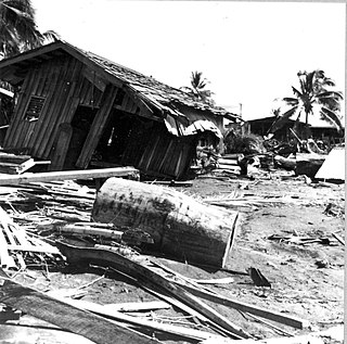
An earthquake off the coast of Samar occurred on August 31, 2012, at 20:47 local time in the Philippines. The populated islands of Visayas were struck by an earthquake of magnitude 7.6. The earthquake has a depth of 45 km. A tsunami warning was announced within the Pacific area and was later lifted after two hours. The Philippine archipelago is located in the Pacific Ring of Fire, where earthquakes and volcanic activity are common.

The 2013 Bohol earthquake occurred on October 15 at in Bohol, an island province located in Central Visayas, Philippines. The magnitude of the earthquake was recorded at Mw 7.2, with epicenter 6 kilometres (3.7 mi) S 24° W of Sagbayan, and its depth of focus was 12 kilometres (7.5 mi). It affected the whole Central Visayas region, particularly Bohol and Cebu. The earthquake was felt in the whole Visayas area and as far as Masbate island in the north and Cotabato provinces in southern Mindanao.

The effects of the 2013 Pacific typhoon season in the Philippines were considered some of the worst in decades. Throughout the year, series of typhoons impacted the country, with the worst damage especially death toll from Typhoon Haiyan during November.

Eastern Visayas is an administrative region in the Philippines, designated as Region VIII. It consists of three main islands, Samar, Leyte and Biliran. The region has six provinces, one independent city and one highly urbanized city namely, Biliran, Leyte, Northern Samar, Samar, Eastern Samar, Southern Leyte, Ormoc and Tacloban. The highly urbanized city of Tacloban is the sole regional center. These provinces and cities occupy the easternmost islands of the Visayas group of islands.

The Leyte Provincial Capitol was the seat of government of the Philippine province of Leyte until 2019. The historic building situated in Tacloban also served as the temporary national capitol in 1944 to 1945 during the World War II era.

The 2017 Batangas earthquakes were an earthquake swarm that occurred from early April to mid-August 2017, affecting the province of Batangas in the Philippines and other nearby areas.

On July 6, 2017, a 6.5 magnitude earthquake hit Leyte, causing at least 4 deaths and 100 injuries. The quake also caused power interruptions in the whole of Eastern Visayas and nearby Bohol.

On April 22, 2019, a 6.1 magnitude earthquake struck the island of Luzon in the Philippines, leaving at least 18 dead, 3 missing and injuring at least 256 others. Despite the fact that the epicenter was in Zambales, most of the damage to infrastructure occurred in the neighboring province of Pampanga, which suffered damage to 29 buildings and structures.

The 2019 Batanes earthquake was a magnitude 5.9 magnitude earthquake which struck Batanes, Philippines on July 27, 2019. It was preceded by a 5.4 magnitude foreshock. Nine people were killed by the combined effects of the earthquakes.

The 2019 Cotabato earthquakes were an earthquake swarm which struck the province of Cotabato on the island of Mindanao in the Philippines in October 2019. Three of these earthquakes were above 6.0 on the moment magnitude scale with a Mercalli intensity of VIII. More than 40 people have been reported dead or missing and nearly 800 were injured as a result of these events.
At 14:11 PST on December 15, 2019, the province of Davao del Sur on the island of Mindanao in the Philippines was struck by an earthquake measuring 6.8 . It had a maximum perceived intensity of VII on the Modified Mercalli Intensity Scale. At least 13 people were killed and another 210 injured.
A 6.6 magnitude earthquake struck the island province of Masbate in the Philippines on August 18, 2020, leaving at least 2 dead and 170 injured.

