This article does not cite any sources .(June 2017) (Learn how and when to remove this template message) |
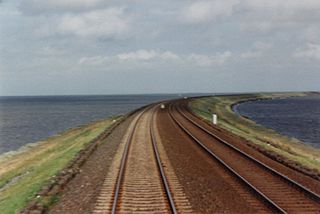
The A 23 road is an A-Grade trunk road in Sri Lanka. It connects Wellawaya with Kumbalwela.
The A 23 passes through Ella to reach Kumbalwela.
This article does not cite any sources .(June 2017) (Learn how and when to remove this template message) |
The A 23 road is an A-Grade trunk road in Sri Lanka. It connects Wellawaya with Kumbalwela.
The A 23 passes through Ella to reach Kumbalwela.
A causeway is a track, road or railway on top of an embankment across "a low, or wet place, or piece of water". It can be constructed of earth, masonry, wood, or concrete. One of the earliest known wooden causeways is the Sweet Track in the Somerset Levels, England, that dates from the Neolithic age. Timber causeways may also be described as both boardwalks and bridges.

The island of Ireland, comprising Northern Ireland and the Republic of Ireland, has an extensive network of tens of thousands of kilometres of public roads, usually surfaced. These roads have been developed and modernised over centuries, from trackways suitable only for walkers and horses, to surfaced roads including modern motorways. The major routes were established before Irish independence and consequently take little cognisance of the border other than a change of identification number and street furniture. Northern Ireland has had motorways since 1962, and has a well-developed network of primary, secondary and local routes. The Republic started work on its motorway network in the early 1980s; and historically, the road network there was once somewhat less well developed. However, the Celtic Tiger economic boom and an influx of European Union structural funding, saw national roads and regional roads in the Republic come up to international standard quite quickly. In the mid-1990s, for example, the Republic went from having only a few short sections of motorway to a network of motorways, dual carriageways and other improvements on most major routes as part of a National Development Plan. Road construction in Northern Ireland now tends to proceed at a slower pace than in the Republic, although a number of important bypasses and upgrades to dual carriageway have recently been completed or are about to begin.

U.S. Route 11 is a signed north–south highway United States highway extending 1,645 miles (2,647 km) across the eastern United States. The southern terminus of the route is at U.S. Route 90 in the Bayou Sauvage National Wildlife Refuge in eastern New Orleans, Louisiana. The northern terminus is at the Rouses Point - Lacolle 223 Border Crossing in Rouses Point, New York. The route continues across the border into Canada as Quebec Route 223. US 11, created in 1926, largely follows the route of the original plan.
Interstate 380 (I-380) is a spur highway in northeast Pennsylvania that connects Interstate 80 with Interstate 81 and Interstate 84. The northern terminus of I-380 is at I-81 and U.S. Route 6 (US 6) in Dunmore; the southern terminus is in Tunkhannock Township at the junction with Interstate 80. The entire length of the highway is 28.2 miles (45.4 km).

The N82 road is a national secondary road in Ireland, and is located entirely in Dublin. The route was designated along the Citywest Road, which runs through the Citywest Business Campus between the N81 west of Tallaght and the Citywest Interchange of the N7.

Kanpur district, meaning Urban Kanpur District is one of the districts of the Uttar Pradesh state of India. It is a part of Kanpur division and its district headquarters is Kanpur.

Tadepalligudem (TPG) is a city in West Godavari district of the Indian state of Andhra Pradesh. It is a municipality and the mandal headquarters of Tadepalligudem mandal in Eluru revenue division.
Ford Motor Company operates several proving grounds worldwide, for development and validation testing of new vehicles.
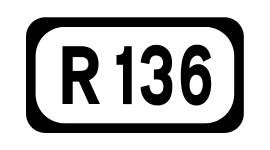
The R136 road is a regional road in Ireland, located in the southwest of Dublin. Named the Outer Ring Road, the route, which is dual carriageway, runs from the N4 at Lucan to the N81 at Tallaght, bypassing west of Clondalkin and crossing the N7 near Citywest. It was built as part of the planning for the new town of Adamstown.
The Trout River is a 20-mile-long (32 km) tributary of the St. Johns River in Duval County, Florida. Located entirely within Jacksonville, the river is brackish in its lower section. The widest point of the river is near the St. Johns River, where it is 0.6 miles (1.0 km) across. The Trout River has wetlands as far as the mouth of the river's longest tributary, the Ribault River.

A seagull intersection or continuous green T-intersection is a type of three-way road intersection, usually used on high traffic volume roads and dual carriageways. This form of intersection is popular in Australia and New Zealand, and sometimes used in the United States and other countries.

Site 81 at the Baikonur Cosmodrome is a launch site used, along with Site 200, by Proton rockets. It consists of two launch pads, areas 23 and 24. Area 24 is used for Proton-K and Proton-M launches, while Area 23 is inactive.
Greek National Road 81 is a single carriageway road in Attica, Greece. It connects the northern suburbs of Athens with Kalamos, near the north coast of Attica.

Strandavatnet is a lake in Hol municipality, Norway. The lake covers an area of 23.75 square kilometres (9.17 sq mi), and lies 975 metres (3,199 ft) above sea level.' The lake is a reservoir for the Rud hydroelectric powerstation in Hovet, Buskerud. In 1952/1953 a dam was constructed which lifted the lake level 28 meters, thus the lake varies between 950 and 978 m above sea level.

The A 6 road is an A-Grade trunk road in Sri Lanka. It connects Ambepussa with Trincomallee.
The A 16 road is an A-Grade trunk road in Sri Lanka. It connects Beragala with Hali Ela.
The A 22 road is an A-Grade trunk road in Sri Lanka. It connects Passara with Monaragala.

Sukma district is the newly formed, southernmost district in the Indian state of Chhattisgarh. It is located in Bastar. The Sukma district borders with Odisha and Telangana.

Bankapasi is a village in Mogalkote CD block in Katwa subdivision of Purba Bardhaman district in the Indian state of West Bengal.
Coordinates: 6°48′52″N81°04′58″E / 6.814537°N 81.082809°E

A geographic coordinate system is a coordinate system that enables every location on Earth to be specified by a set of numbers, letters or symbols. The coordinates are often chosen such that one of the numbers represents a vertical position and two or three of the numbers represent a horizontal position; alternatively, a geographic position may be expressed in a combined three-dimensional Cartesian vector. A common choice of coordinates is latitude, longitude and elevation. To specify a location on a plane requires a map projection.
| This Sri Lankan road or road transport-related article is a stub. You can help Wikipedia by expanding it. |
