
White Pine is a town in Jefferson county in the U.S. state of Tennessee. It is part of the Morristown, Tennessee Metropolitan Statistical Area. The population was 2,196 at the 2010 census.

Jiading is a suburban district of Shanghai. It had a population of 1,471,100 in 2010.

The R113 road is a regional road in Ireland. Located in Dublin, it forms a semi-orbital route around the south of the city. As of 2007, clockwise, it starts at the N31 at Temple Hill in Blackrock and ends at a junction with the N4 at Palmerstown.

The N82 road is a national secondary road in Ireland, and is located entirely in Dublin. The route was designated along the Citywest Road, which runs through the Citywest Business Campus between the N81 west of Tallaght and the Citywest Interchange of the N7.
Route 322 is a collector road in the Canadian province of Nova Scotia.

Golubovci is a small town in the Podgorica Municipality of Montenegro. It is the seat of the Golubovci City Municipality, a subdivision of the Podgorica Municipality. The town is located some 15 km south of the city of Podgorica, in the fertile Zeta valley. It has 3,110 residents according to 2011 census, while the Golubovci City Municipality accounts for some 16,093 residents.

Kalmunai is a city in the Ampara District of Eastern Province, Sri Lanka. It had a total population of 106,780 as of 2011. It is the one of Muslim-majority municipality in the country. When Muslims in Colombo were expelled by Portuguese in the 17th century, they fled to Kandy and sought refuge with the king in Kandy. Then the king resettled these Muslim refugees in Kalmunai and Kattankudy (4000). Kalmunai was the Royal farm of the king. Because of this settlement, it became a Muslim-majority area.

A seagull intersection or continuous green T-intersection is a type of three-way road intersection, usually used on high traffic volume roads and dual carriageways. This form of intersection is popular in Australia and New Zealand, and sometimes used in the United States and other countries.

Karainagar is located 20 km from Jaffna, Sri Lanka, on the Karaitivu (Island). In Tamil, means a place with abundant Kaarai trees.

Strandavatnet is a lake in Hol municipality, Norway. The lake covers an area of 23.75 square kilometres (9.17 sq mi), and lies 975 metres (3,199 ft) above sea level.' The lake is a reservoir for the Rud hydroelectric powerstation in Hovet, Buskerud. In 1952/1953 a dam was constructed which lifted the lake level 28 meters, thus the lake varies between 950 and 978 m above sea level.

The A4 Highway is the longest highway in Sri Lanka, at 430 kilometres (270 mi) in length. It connects Colombo with Batticaloa, through a large number of important cities in Western, Sabaragamuwa, Uva and Eastern provinces.
The A 11 road is an A-Grade trunk road in Sri Lanka. It connects the Maradankadawala with Tirikkondiadimadu.
The A 25 road is an A-Grade trunk road in Sri Lanka. It connects the Siyabalanduwa with Ampara.

The A 27 road is an A-Grade trunk road in Sri Lanka. It connects Ampara with Maha Oya.
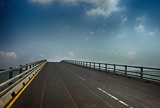
Sangupiddy Bridge is a road bridge across Jaffna Lagoon in northern Sri Lanka. It connects Sangupiddy in Kilinochchi District to Karaitivu in Jaffna District. It is one of only two road bridges connecting the densely populated Jaffna Peninsula with the mainland.

Sukma district is the newly formed, southernmost district in the Indian state of Chhattisgarh. It is located in Bastar. The Sukma district borders with Odisha and Telangana.

Kovilan Point Lighthouse is a lighthouse on the island of Karaitivu in northern Sri Lanka. Built in 1916, the 30 metres (98 ft) white lighthouse has a round masonry tower. The light itself is 31 metres (102 ft) above sea level. An observer on a ship 30.48 metres (100.0 ft) tall can see this light from 21.4 nautical miles


