Garrett County (gərɛt) is the westernmost county of the U.S. state of Maryland. As of the 2010 census, the population was 30,097, making it the third-least populous county in Maryland. Its county seat is Oakland. The county was named for John Work Garrett (1820–1884), president of the Baltimore and Ohio Railroad. Created from Allegany County, Maryland in 1872, it was the last Maryland county to be formed.
The Grand Trunk Road is one of Asia's oldest and longest major roads — founded around 3rd century BCE by the Mauryan Empire of ancient India. For more than two millennia, it has linked the South Asia with Central Asia. It runs from Chittagong, Bangladesh west to Howrah, West Bengal in India, then across Northern India through Delhi, passing from Amritsar. From there, the road continues towards Lahore and Peshawar in Pakistan, finally terminating in Kabul, Afghanistan.

Bolshevik Island is an island in Severnaya Zemlya, Krasnoyarsk Krai, Russian Arctic.

A jughandle is a type of ramp or slip road that changes the way traffic turns left at an at-grade intersection. Instead of a standard left turn being made from the left lane, left-turning traffic uses a ramp on the right side of the road. In a standard forward jughandle or near-side jughandle, the ramp leaves before the intersection, and left-turning traffic turns left off it rather than the through road. Right turns are also made using the jughandle.

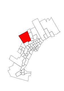
Mississauga—Streetsville is a federal electoral district in Ontario, Canada, that has been represented in the House of Commons of Canada since 2004. This riding is centred on the villages of Streetsville and Meadowvale.
The Gulf of Mannar Marine National Park is a protected area of India consisting of 21 small islands (islets) and adjacent coral reefs in the Gulf of Mannar in the Indian Ocean. It lies 1 to 10 km away from the east coast of Tamil Nadu, India for 160 km between Thoothukudi (Tuticorin) and Dhanushkodi. It is the core area of the Gulf of Mannar Biosphere Reserve which includes a 10 km buffer zone around the park, including the populated coastal area. The park has a high diversity of plants and animals in its marine, intertidal and near shore habitats. Public access inside the Park is limited to glass bottom boat rides.
Washboarding or corrugation is the formation of periodic, transverse ripples in the surface of gravel and dirt roads. Washboarding occurs in dry, granular road material with repeated traffic, traveling at speeds above 8.0 kilometres per hour (5 mph). Washboarding creates an uncomfortable ride for the occupants of traversing vehicles and hazardous driving conditions for vehicles that travel too fast to maintain traction and control.

A national primary road is a road classification in Ireland. National primary roads form the major routes between the major urban centres. There are 2649 km of national primary roads. This category of road has the prefix "N" followed by one or two digits. Motorways are prefixed "M" followed by one or two digits.
Mohawk Sports Park, is a large park on the east mountain of Hamilton, Ontario, 1100 Mohawk Road East, also known as Commonwealth Park and Upper King's Forest Park.
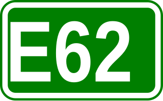
European route E 62 is a road in Europe, part of the United Nations International E-road network. Approximately 1,307 kilometers (812 mi) long, it connects the French Atlantic port city of Nantes to Genoa, largest of Italy's port cities. Between France and Italy it also passes through Switzerland, via Geneva and Lausanne. After crossing into Italy, the E 62 passes Milan, Italy's largest commercial and industrial centre, before descending to Genoa on the Mediterranean coast.
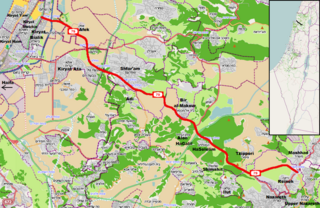
Highway 79 is an east-west highway in northern Israel. It crosses the Zevulun Valley and the western Lower Galilee. The road leads from Kiryat Bialik to Mashhad north of Nazareth. It is 27 km long.
Madhuranthakam is a legislative assembly constituency in the Indian state of Tamil Nadu. It forms a part of Kancheepuram Lok Sabha Constituency for national elections to the Parliament of India. It is reserved for candidates from the Scheduled Castes.

Tirupati Eparchaean Unconformity, a notified National Geo-heritage Monument is a major discontinuity of stratigraphic significance that represents a period of remarkable serenity in the geological history of the earth i.e. sudden changes and discontinuity in the rock layers in earth's crust. It is seen at the steep natural slopes, road scars and ravines in the Tirupati – Tirumala Ghat road in Chittoor district of Andhra Pradesh, India.
Padalam (படாளம்) is an important and an emerging suburb of South-west Chennai, located along the busy GST Road.

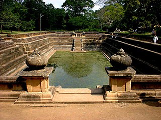
The A 6 road is an A-Grade trunk road in Sri Lanka. It connects Ambepussa with Trincomallee.

The A 15 road is an A-Grade trunk road in Sri Lanka. It connects Batticalao with Trincomallee.

Thornhill is a provincial electoral district in Ontario, Canada, that has been represented in the Legislative Assembly of Ontario since 1999.
King—Vaughan is a federal electoral district in Ontario, Canada.
Walajabad taluk is a taluk in the Kanchipuram district of Tamil Nadu, India. At the 2011 Census of India, the taluk covered an area of 339.03 square kilometres (130.90 sq mi) with a population of 125,868. The headquarters of the taluk is the town of Walajabad.