
Gampaha is an urban city in Gampaha District, Western Province, Sri Lanka. It is situated to the north-east of the capital Colombo. It is the sixth largest urban area in Western Province, after Colombo, Negombo, Kalutara, Panadura and Avissawella. Gampaha is also the second largest municipal centre in Gampaha district, after Negombo. Gampaha has a land area of 25.8 ha and is home to the offices of 75 government institutions.
Pussellawa Sinhala: පුස්සැල්ලාව. Tamil: புசல்லாவை, is a small town in Kandy District, Sri Lanka. It is located along the A5 road between Gampola and Nuwara Eliya.

Dunhinda Falls is a waterfall located about 5 kilometres (3.1 mi) from Badulla town in Sri Lanka.The Dunhinda Falls is one of Sri Lanka's most beautiful waterfalls.The waterfall, which is 64 metres (210 ft) high gets its name from the smoky dew drops spray, which surrounds the area at the foot of the waterfall. It's also known as Bridal fall as the shape of the waterfall reflect a bridal veil. The water fall is created by the river called Badulu Oya which goes through the Badulla town.

A seagull intersection or continuous green T-intersection is a type of three-way road intersection, usually used on high traffic volume roads and dual carriageways. This form of intersection is popular in Australia and New Zealand, and sometimes used in the United States and other countries.
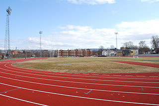
Øya stadion, also known as Trondheim stadion, is an athletics facility in Nidarø, Trondheim, Norway. The field was established as "Øen stadion" in 1900 as a combined athletics field and skating rink.
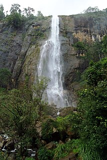
Diyaluma Falls is 220 m (720 ft) high and the second highest waterfall in Sri Lanka and 361st highest waterfall in the world. It is situated 6 km (3.7 mi) away from Koslanda in Badulla District on Colombo-Badulla highway. The Falls are formed by Punagala Oya, a tributary of Kuda Oya which in turn, is a tributary of Kirindi Oya.
Akkaraipattu is a city in the Ampara District, Eastern Province of Sri Lanka. It is approximately 250 km (160 mi) east of Colombo. During the period of British rule, the city was called Karunkodithivu. Akkaraipattu acts as an agro-economic hub. Vast extents of paddy field surround the township.
Pottuvil or Pothuvil or Poththuvil (Sinhala:පොතුවිල්)(Tamil: பொத்துவில்) is a town in the Ampara District of Sri Lanka, located on the eastern coast of the Island. It is situated 4 km (2.5 mi) north of the popular tourist destination Arugam Bay.

The Bureau of Royal Thai Mint,, is situated in Pathum Thani, Thailand. It is a sub-division of the Treasury Department, Ministry of Finance.

The A 5 road is an A-Grade trunk road in Sri Lanka. It connects the Peradeniya with Chenkalady.

The A 6 road is an A-Grade trunk road in Sri Lanka. It connects Ambepussa with Trincomallee.
The A 12 road is an A-Grade trunk road in Sri Lanka. It connects the Puttalam with Trincomallee.
West Watta is a village in Sri Lanka. It is located within Central Province, slightly southeast. The A2 road runs through the village; it is close to the Kinkini Wehera Raja Maha Viharaya Buddhist Temple and next to the Kirindi Oya River.
Aranayaka is a town in the Kegalle District of Sabaragamuwa Province in Sri Lanka. Its agricultural economy revolves around local rubber, tea, banana and mahogany plantations.
The Deduru Oya Dam is an embankment dam built across the Deduru River in Kurunegala District of Sri Lanka. Built in 2014, the primary purpose of the dam is to retain approximately a billion cubic metres of water for irrigation purposes, which would otherwise flow out to sea. Construction of the dam began in 2006 and was ceremonially completed in 2014, with the presence of former President Mahinda Rajapaksa.

The Rambakan Oya Dam is an embankment dam in Maha Oya, Eastern Province, Sri Lanka. The reservoir was designed and constructed by the Sri Lanka Mahaveli Authority and currently functions under the direction of the Ministry of Irrigation and Water Resources Management. It have been created by building an Earthen dam of which is about 1225m in length across the river of Mundeni Aru.

The Maha Oya is a major stream in the Sabaragamuwa Province of Sri Lanka. It measures approximately 134 km (83 mi) in length. It runs across four provinces and five districts. Maha Oya has 14 Water supply networks to serve the need of water and more than 1 million people live by the river.

Sam Yot station is a Bangkok MRT rapid transit station on the Blue Line, located underground from Sam Yot intersection of Charoen Krung Road and Maha Chai Road, of which the station is named after, to the Unakan Intersection between Charoen Krung and Burapha Roads, located in Bangkok, Thailand. The station was designed to reflect the Wang Burapha community in the surrounding area and was above-ground structures built in the Sino-Portuguese style to blend in with the local atmosphere. The platforms are designed with a pale yellow color to reflect the station building's color. The station will connect to the MRT Purple Line once the southern extension is completed.


