Avissawella, is a township in Sri Lanka, governed by an Urban Council, situated on the A4 route from Colombo to Ratnapura, Colombo District, Western Province, Sri Lanka, approximately 59 km east of capital Colombo. It is also known as Seethawakapura.
Nuwara Eliya is a city in the hill country of the Central Province, Sri Lanka. Its name means "city on the plain " or "city of light". The city is the administrative capital of Nuwara Eliya District, with a picturesque landscape and temperate climate. It is at an altitude of 1,868 m (6,128 ft) and is considered to be the most important location for tea production in Sri Lanka. The city is overlooked by Pidurutalagala, the tallest mountain in Sri Lanka. Nuwara Eliya is known for its temperate, cool climate – the coolest area in Sri Lanka.
Yatiyanthota is a town in Kegalle District, in Sabaragamuwa Province, Sri Lanka.
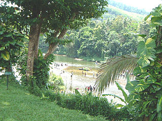
Kitulgala is a small town in the west of Sri Lanka. It is in the wet zone rain forest, which gets two monsoons each year, and is one of the wettest places in the country. Nevertheless, it comes alive in the first three months of the year, especially in February, the driest month. The Academy Award-winning The Bridge on the River Kwai was filmed on the Kelani River near Kitulgala, although nothing remains now except the concrete foundations for the bridge. Kitulgala is also a base for white-water rafting, which starts a few kilometres upstream and also popular as a location for adventure based training programs.
Hatton is a town in the Nuwara Eliya District of Central Province, Sri Lanka governed by the Hatton-Dickoya Urban Council. Hatton is a major centre of the Sri Lankan tea industry.
A geographic coordinate system is a coordinate system that enables every location on Earth to be specified by a set of numbers, letters or symbols. The coordinates are often chosen such that one of the numbers represents a vertical position and two or three of the numbers represent a horizontal position; alternatively, a geographic position may be expressed in a combined three-dimensional Cartesian vector. A common choice of coordinates is latitude, longitude and elevation. To specify a location on a plane requires a map projection.
This page is based on this Wikipedia article Text is available under the CC BY-SA 4.0 license; additional terms may apply. Images, videos and audio are available under their respective licenses.
Related Research Articles
Nuwara Eliya District is a district in Central Province, Sri Lanka, centered on the tourist city of Nuwara Eliya.
Dickoya is a town in Nuwara Eliya District in the Central Province of Sri Lanka. Dickoya forms Hatton-Dickoya urban council with Hatton.
Lindula is a town and Urban Council in Nuwara Eliya District in the Central Province of Sri Lanka. With Talawakele it forms the Talawakele-Linduala urban council.
The A 5 road is an A-Grade trunk road in Sri Lanka. It connects the Peradeniya with Chenkalady.
The Hill Club is a gentlemen's club in Nuwara Eliya, Sri Lanka. Established 1876 by British coffee planters in the hill station of Nuwara Eliya.
Kandapola (කඳපොල) is a village in Nuwara Eliya, Sri Lanka. It is located within Central Province.
Nildandahinna is a town in Sri Lanka. It is located within Nuwara Eliya district.
Nuwara Eliya Town is a village in Sri Lanka. It is located within Central Province.
Ramboda is a village in Sri Lanka. It is located within Central Province. The Wavenden Estate in Ramboda is the birthplace of British Admiral of the Fleet Lord Fisher.
Talawakelle is a town in Nuwara Eliya District in the Central Province, Sri Lanka, governed by an Urban Council. It is the center of Dimbula tea planting district, the largest tea growing area in Sri Lanka. It is situated on A7 colombo-Nuwara Eliya highway. The altitude of Talawakelle is 1,198 metres (3,930 ft). Talawakelle railway station is one of the major stops of Udarata or Main railway line. The town is administrated by Talawakelle-Lindula urban council.
"Walapane". is located in Nuwara Eliya District of Sri Lanka. It is a high country area with lots of green mountains. The location of the Walapane area can be identify from Latitude: 7.095404, Longitude: 80.861671. It was called Wathtumulla in the past. The name Watumulla derived from the former tea factory which was located in the heart of the Walapane town and now demolished since the production of Wattumulla Plantation declined. Walapane is administrated by the government of *Sri Lanka through *Walapane Divisional Secretariat.
World's End is located within the Horton Plains National Park in Nuwara Eliya, Sri Lanka. It is a sheer cliff, with a drop of about 4,000 feet (1,200 m). It is one of the most visited parts of the Park, and a key tourist attraction in the Nuwara Eliya District and the country at large.
Uda Pussellawa Railway (UPR) or Udupussallawa Railway was a 2 ft 6 in narrow gauge railway line that existed in Ceylon between 1903 and 1948. The line connected Nanu Oya railway station with Ragala via Nuwara Eliya.
Nuwara Eliya Racecourse in Nuwara Eliya, Sri Lanka is the only remaining horse racing venue in Sri Lanka. Situated 1,868 metres (6,129 ft) above sea level the race course is one of the highest in the world. The track has a circumference of 1,800 metres (5,900 ft) with a 333-metre straight.
Nuwara Eliya electoral district was an electoral district of Sri Lanka between August 1947 and July 1977. The district was named after the City of Nuwara Eliya in Nuwara Eliya District, Central Province. The 1978 Constitution of Sri Lanka introduced the proportional representation electoral system for electing members of Parliament. The existing 160 mainly single-member electoral districts were replaced with 22 multi-member electoral districts. Nuwara Eliya electoral district was replaced by the Nuwara Eliya multi-member electoral district at the 1989 general elections, the first under the proportional representation system, Nuwara Eliya continues to be a polling division of the multi-member electoral district.
The Nuwara Eliya Post Office is located in the centre of Nuwara Eliya and is one of the oldest post offices in Sri Lanka.
Holy Trinity Church is an Anglican church in Nuwara Eliya in Sri Lanka.