Newberry Township is a township in York County, Pennsylvania, United States. The population was 15,285 at the 2010 census.

The history of the Cape Colony from 1806 to 1870 spans the period of the history of the Cape Colony during the Cape Frontier Wars, which lasted from 1779 to 1879. The wars were fought between the European colonists and the native Xhosa who, defending their land, fought against European rule.

The Cape Flats is an expansive, low-lying, flat area situated to the southeast of the central business district of Cape Town.

Griqualand East, officially known as New Griqualand, was one of four short-lived Griqua states in Southern Africa from the early 1860s until the late 1870s and was located between the Umzimkulu and Kinira Rivers, south of the Sotho Kingdom.

Matatiele is a town located in the northern part of the Eastern Cape Province of South Africa. According to the South African National Census of 2011, its 12,466 residents and 4,107 households make Matatiele the largest populated town in the Matatiele Local Municipality.

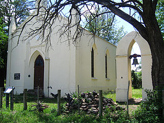
Albany, South Africa was a district in the Eastern Cape, South Africa. Grahamstown was traditionally the administrative capital, cultural centre and largest town of the Albany district.

Gansbaai is a fishing town and popular tourist destination in the Overberg District Municipality, Western Cape, South Africa. It is known for its dense population of great white sharks and as a whale-watching location.

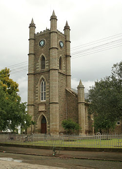
Makhanda, previously known as Grahamstown, is a town of about 140,000 people in the Eastern Cape province of South Africa. It is situated about 110 kilometres (70 mi) northeast of Gqeberha and 130 kilometres (80 mi) southwest of East London. Makhanda is the largest town in the Makana Local Municipality, and the seat of the municipal council. It also hosts Rhodes University, the Eastern Cape Division of the High Court, the South African Library for the Blind (SALB), a diocese of the Anglican Church of Southern Africa, and 6 South African Infantry Battalion. Furthermore, located approximately 3 km south-east of the town lies the world renowned Waterloo Farm, the only estuarine fossil site in the world from 360 million years ago with exceptional soft-tissue preservation.

King William's Town is a town in the Eastern Cape province of South Africa along the banks of the Buffalo River. The city is about 60 kilometres (37 mi) northwest of the Indian Ocean port of East London. King William’s Town, with a population of around 100,000 inhabitants, forms part of the Buffalo City Metropolitan Municipality.
Stutterheim is a town with a population of 46,730 in South Africa, situated in the Border region of the Eastern Cape province.

Langa is a township in Cape Town, South Africa. Its name in Xhosa means "sun". The township was initially built in phases before being formally opened in 1927. It was developed as a result of South Africa's 1923 Urban Areas Act, which was designed to force Africans to move from their homes into segregated locations. Similar to Nyanga, Langa is one of the many areas in South Africa that were designated for Black Africans before the apartheid era. It is the oldest of such suburbs in Cape Town and was the location of much resistance to apartheid.
British Kaffraria was a British colony/subordinate administrative entity in present-day South Africa, consisting of the districts now known as King William’s Town and East London. It was also called Queen Adelaide's Province.
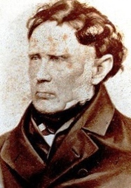
Sir Andries Stockenström, 1st Baronet, was lieutenant governor of British Kaffraria from 13 September 1836 to 9 August 1838.

South African Bantu-speaking peoples are the majority of Black South Africans. Occasionally grouped as Bantu, the term itself is derived from the word for "people" common to many of the Bantu languages. The Oxford Dictionary of South African English describes its contemporary usage in a racial context as "obsolescent and offensive" because of its strong association with white minority rule with their Apartheid system. However, Bantu is used without pejorative connotations in other parts of Africa and is still used in South Africa as the group term for the language family.
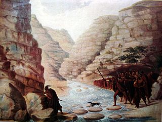
The Xhosa Wars were a series of nine wars or flare-ups between the Xhosa Kingdom and encroaching European settlers in what is now the Eastern Cape in South Africa. These events were the longest-running military action in the history of European colonialism in Africa.

Butterworth is a town in the Eastern Cape Province, South Africa. Butterworth has a population of 45,900 and is situated on the N2 national highway 111 km north of East London.

The Iziko South African Museum is a South African national museum located in Cape Town. The museum was founded in 1825, the first in the country. It has been on its present site in the Company's Garden since 1897. The museum houses important African zoology, palaeontology and archaeology collections.
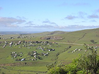
Whittlesea is a semi-rural town situated in the Hewu district, 37 km south of Queenstown, Eastern Cape Province, South Africa. The town is made up of the townships Ekuphumleni, Bhede, Extension 4, Extension 5 and Sada. The town falls under the Enoch Mgijima Local Municipality which is under the Chris Hani District Municipality. Surrounding Whittlesea are 36 villages which make up the Hewu district.
Xhosa people are a Nguni ethnic group in Southern Africa whose homeland is primarily within the modern-day Eastern Cape. There is a small but significant Xhosa-speaking (Mfengu) community in Zimbabwe, and their language, isiXhosa, is recognised as a national language.
Sada is a semi-rural settlement, situated 3 km away from Whittlesea, 30 km north of Seymour and 40 km south of Queenstown, Eastern Cape Province. The word Sada means "finally" or "at last" in isiXhosa because the first settlers struggled to find a place before they settled in the area in 1964.