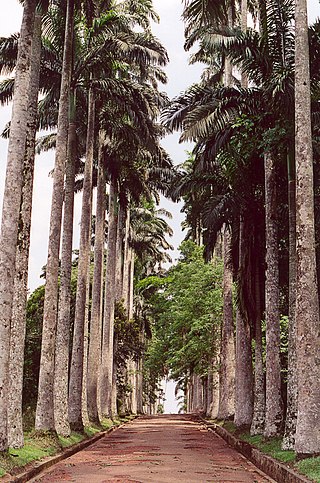
Aburi is a town in the Akuapim South Municipal District of the Eastern Region of south Ghana famous for the Aburi Botanical Gardens and the Odwira festival. Aburi has a population of 18,701 people as of 2013.

Nsawam is a town in south Ghana and is the capital of the Nsawam-Adoagyire Municipal District, a district in the Eastern Region of south Ghana. The main ethnic group is Akan, followed by Ga and then Ewe. Nsawam is controlled by Nsawam-Adoagyire Municipal District (ASMD). As of 2013, Nsawam has a settlement population of 44,522 people. Nsawam is situated on the main railway between Accra and Kumasi and highway to Kumasi. It has Densu river acting as a border between itself and Adoagyiri. Densu River, is the main source of water for both domestic and industrial purposes for people in and around Nsawam.

The Eastern Region is located in south Ghana and is one of the sixteen administrative regions of Ghana. Eastern region is bordered to the east by the Lake Volta, to the north by Bono East Region and Ashanti region, to the west by Ashanti region, to the south by Central region and Greater Accra Region. Akans are the dominant inhabitants and natives of Eastern region and Akan, Ewe, Krobo, Hausa and English are the main spoken languages. The capital town of Eastern Region is Koforidua.The Eastern region is the location of the Akosombo dam and the economy of the Eastern region is dominated by its high-capacity electricity generation. Eastern region covers an area of 19,323 square kilometres, which is about 8.1% of Ghana's total landform.

Suhum/Kraboa/Coaltar District is a former district that was located in Eastern Region, Ghana. Originally created as an ordinary district assembly in 1988, which was created from the former Suhum-Kraboa-Coaltar District Council. However on 28 June 2012, it was split off into two new districts: Suhum Municipal District and Ayensuano District. The district assembly was located in the southern part of Eastern Region and had Suhum as its capital town.

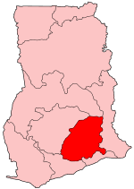
Akuapim South District is one of the thirty-three districts in Eastern Region, Ghana. Originally it was formerly part of the then-larger and first Akuapim South District in 1988, which it was created from the former Akuapim District Council; until it was elevated to municipal district assembly status to become Akuapim South Municipal District, with Nsawam as its capital town. However on 6 February 2012, the northeast part of the district was split off to create a new Akuapim South District, with Aburi as its capital town; thus the remaining part has been renamed as Nsawam Adoagyire Municipal District, with Nsawam as its capital town. The district assembly is located in the southeast part of Eastern Region and has Aburi as its capital town.
Stephen Amoanor Kwao is a Ghanaian educationist and politician. He a former Member of Parliament for the Upper Manya constituency and a Minister of State at the Office of the President of Ghana. He is also a former deputy director of the Ghana Education service as well as a former national secretary of the National Democratic Congress. He is also a former minister for Employment and Social Welfare.
Asesewa is a small town and the district capital of Upper Manya Krobo district in the Eastern region of southern Ghana. Asesewa is a historic trading post. It has a mix of cultures who are from all over Ghana. It is located about 45 km from the regional capital of Eastern region, Koforidua.
Adenta is a small town and is the capital of Adenta Municipal district, a district in the Greater Accra Region of Ghana. The town is known for the West Africa Secondary School. The school is a second cycle institution. It is also known for the SSNIT Housing. It is located on the Accra - Aburi Highway after Madina.

Amasama is a small town and is the capital of Ga West Municipal District, an MMDA located within the Greater Accra Region of Ghana. The town is known for the Amasama Secondary Technical School. The school is a second cycle institution.
Jacobu is the capital town of Amansie Central, a district in the Ashanti Region of Ghana. It is near Bekwai. Jacobu and its neighbouring towns form the Odotobri paramountcy.
Assin Fosu is a town and is the capital of Assin Central Municipal District, in the Central Region of Ghana. Assin Fosu is the 65th most populous settlement in Ghana, with a population of 20,541. The town is known for the Obiri Yeboah Secondary School School. The school is a second cycle institution.
Pakro is a village in the Akuapim South Municipal district, a district in the Eastern Region of Ghana.
Pampanso is a village in the Akuapim South Municipal district, a district in the Eastern Region of Ghana.
Dago is a village in the Akuapim South Municipal district, a district in the Eastern Region of Ghana.
Pokrom is a village in the Akuapim South Municipal district, a district in the Eastern Region of Ghana.
Akwapim South is one of the constituencies represented in the Parliament of Ghana. It elects one Member of Parliament (MP) by the first past the post system of election. Akwapim South used to be known as the Aburi-Nsawam constituency until it was divided in 2012 which gave us Akwapim South and Nsawam Adoagyiri constituencies.
Nsawam Adoagyiri is one of the constituencies represented in the Parliament of Ghana. It elects one Member of Parliament (MP) by the first past the post system of election. Nsawam Adoagyiri is one of the constituencies created from the now defunct Aburi-Nsawam constituency in the Eastern Region of Ghana.
Nsawam-Adoagyire Municipal District is one of the thirty-three districts in Eastern Region, Ghana. Originally created as an ordinary district assembly in 1988 when it was known as the first Akuapim South District, which it was created from the former Akuapim District Council; until it was elevated to municipal district assembly status to become Akuapim South Municipal District, with Nsawam as its capital town. However on 6 February 2012, the northeast part of the district was split off to create a new Akuapim South District, with Aburi as its capital town; thus the remaining part has been renamed as Nsawam-Adoagyire Municipal District, with Nsawam as its capital town. The municipality is located in the southeast part of Eastern Region and has Nsawam as its capital town.
Akuapim District is a former district council that was located in Eastern Region, Ghana. Originally created as an ordinary district assembly in 1975. However, on 10 March 1989, it was split off into two new district assemblies: Akuapim South District and Akuapim North District. The district assembly was located in the southeast part of Eastern Region and had Nsawam as its capital town.
Hebron is a town near Nsawam in southern Ghana and in the Nsawam-Adoagyire Municipal District, a district in the Eastern Region of south Ghana. Hebron falls under the administrative district of Nsawam-Adoagyire Municipal District (ASMD). Hebron is situated on the main Accra to Nsawam a highway to Kumasi.

