Aigun

Last updated • 4 min readFrom Wikipedia, The Free Encyclopedia
Aigun
瑷珲
Aihui
Manchu  transcription(s)
   Manchu ᠠᡳ᠌ᡥᡡᠨ
   Transliteration aihūn
Chinese  transcription(s)
   Traditional 璦琿
   Simplified 瑷珲
   Pinyin Ài Hún
Country China
Province Heilongjiang
Prefecture Heihe
Time zone UTC+8 (China Standard Time)

49°58′41″N127°29′24″E / 49.978°N 127.490°E / 49.978; 127.490

Contents

Aigou (Aigun) shown as one of the few towns on the Amur, and one of the most important places in the region, on a 1706 French map Lisle - Carte de Tartarie (Detail).jpg
Aigou (Aigun) shown as one of the few towns on the Amur, and one of the most important places in the region, on a 1706 French map

Aigun (simplified Chinese :瑷珲; traditional Chinese :璦琿; pinyin :Ài Hún; Manchu: ᠠᡳ᠌ᡥᡡᠨaihūn; Russian : Айгунь, romanized: Aigun) was a historic Chinese town in northern Manchuria, situated on the right bank of the Amur River, some 30 kilometres (19 mi) south (downstream) from the central urban area of Heihe (which is across the Amur from the mouth of the Zeya River and Blagoveschensk). [1]

The Chinese name of the town, which literally means "Bright Jade", was a transliteration of the Manchu (or Ducher) name of the town. The current Mainland Chinese pronunciation Ài Huī does not reflect this, unlike the Taiwanese pronunciation which still follows the Old National Pronunciation Ài Hún.

Today the former city of Aigun is called Aihui Town (ᠠᡳ᠌ᡥᡡᠨ
ᡥᠣᡨᠣᠨ
aihūn hoton) and is part of Aihui District, which in turn is part of the prefecture-level city of Heihe. Heihe is one of the major cities in Heilongjiang Province.

History

The predecessor of Aigun was a town of the indigenous Ducher people of the Amur Valley, located on the left (northeastern - now Russian) bank of the Amur River. The site of this town, whose name was reported by the Russian explorer Yerofey Khabarov as Aytyun (Айтюн) in 1652, is currently known to archaeologists as the Grodekovo site (Гродековское городище), after the nearby village of Grodekovo. It is thought to have been populated since around the end of the 1st or the beginning of the 2nd millennium AD. [2]

Some sources report a Chinese presence on the middle Amur – a fort existed at Aigun for about 20 years during the Yongle era on the left (northwestern) shore of the Amur downstream from the mouth of the Zeya River. This Ming Dynasty Aigun was located on the opposite bank to the later Aigun that was relocated during the Qing Dynasty. [3]

Aaihom (destroyed) shown on the 1773 map opposite Sahalien Hotun, following d'Anville's map from 1734 Kitchen-21-Russia-Amur-2817.jpg
Aaihom (destroyed) shown on the 1773 map opposite Sahalien Hotun, following d'Anville's map from 1734

The Ducher town was probably vacated when the Duchers were evacuated by the Manchu Chinese Qing Dynasty to the Sungari or Hurka in the mid-1650s. [2] In 1683-85 the Manchus re-used the site as a base for their campaign against the Russian fort of Albazin. [4]

After the capture of Albazin in 1685 or 1686, the Manchus relocated the town to a new site on the right (southwestern) bank of the Amur, about 3 miles (4.8 km) downstream from the original site. [5] [6] The new site occupied the location of the former village of a Daurian chief named Tolga. [5] The city became known primarily under its Manchu name Saghalien Ula Hotun or Hoton (Manchu: ᠰᠠᡥᠠᠯᡳᠶᠠᠨ
ᡠᠯᠠ
ᡥᠣᡨᠣᠨ
Sahaliyan Ula Hoton), [7] and sometimes also under the Chinese translation of this name, Heilongjiang Cheng (黑龍江城). Both names mean "Black River City", but by the 19th century the name "Aigun" again became more current in the western languages.

For a number of years after 1683, Aigun served as the capital (the seat of the Military Governor) of Heilongjiang Province, until the capital was moved to Nenjiang (Mergen) in 1690, and later to Qiqihar. [8] Aigun, however, remained the seat of the Deputy Lieutenant-General (Fu dutong), responsible for a large district covering much of the Amur Valley within the province of Heilongjiang as it existed in those days.

As a part of a nationwide Sino-French cartographic program, Aigun (or, rather, Saghalien Ula hoton) was visited ca. 1709 by the Jesuits Jean-Baptiste Régis, Pierre Jartoux, and Xavier Ehrenbert Fridelli, [9] who found it a well-defended town, serving as the base of a Manchu river fleet controlling the Amur River region. Surrounded by numerous villages on the fertile riverside plain, the town was well provisioned with foodstuffs. [7]

Muravyov's fleet off Aigun in 1854 Ravenstein-p118-Sverbeyev-View-of-Aigun-1854.png
Muravyov's fleet off Aigun in 1854

It was at Aigun in May 1858 that Nikolay Muravyov concluded the Aigun Treaty, according to which the left bank of the Amur River was conceded to Russia. [10]

During the Boxer Rebellion of 1900, for a few weeks Aigun was the center of military action directed against the Russians. [10] On July 22, Aigun was captured by Russian troops.

In 1913 Aigun became the county seat of the newly created Aigun County (瑷珲县, Àihuī Xiàn), which was renamed Aihui County (爱辉县, Àihuī Xiàn, the pronunciation remained unchanged) in December 1956.

The Manchus of the Chinese capital Peking (now known as Beijing) were influenced by the Chinese dialect spoken in the area to the point where pronouncing Manchu sounds was hard for them, and they pronounced Manchu according to Chinese phonetics, while in contrast, the Manchus of Aigun could both pronounce Manchu sounds properly and mimick the sinicised pronunciation of Peking Manchus, since they learned the Pekinese pronunciation from either studying in Peking or from officials sent to Aigun from the capital, and they could tell them apart, using the Chinese influenced Pekinese pronunciation when demonstrating that they were better educated or their superior stature in society. [11] [12]

On November 15, 1980, Heihe City was created, and on June 6, 1983, Aihui County was abolished and merged into the Heihe City. [13]

Commemoration

There are a number of historical sites in today's Aihui Town (30 km south of downtown Heihe) related to the historical Aigun. They include Aihui Ancient City (瑷珲古城), Aihui Heroic Defenders' of the Fatherland Garden (瑷珲卫国英雄园, Àihuī Wèiguó Yīngxióng Yuán), and Aihui History Museum (瑷珲历史陈列馆, Àihuī Lìshǐ Chénliè Guǎn). [14]

Related Research Articles

<span class="mw-page-title-main">Amur</span> Major river in the Russian Far East and Northeast China

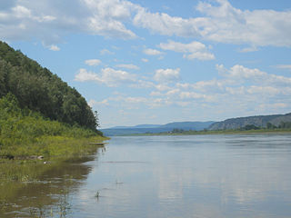
The Amur River or Heilong River is a perennial river in Northeast Asia, forming the natural border between the Russian Far East and Northeast China. The Amur proper is 2,824 km (1,755 mi) long, and has a drainage basin of 1,855,000 km2 (716,000 sq mi). If including its main stem tributary, the Argun, the Amur is 4,444 km (2,761 mi) long, making it the world's tenth longest river.

<span class="mw-page-title-main">Sakhalin</span> Island in the Sea of Okhotsk

Sakhalin is an island in Northeast Asia. Its north coast lies 6.5 km (4.0 mi) off the southeastern coast of Khabarovsk Krai in Russia, while its southern tip lies 40 kilometres (25 mi) north of Japan's Hokkaido. An island of the West Pacific, Sakhalin divides the Sea of Okhotsk to its east from the Sea of Japan to its southwest. It is administered as part of Sakhalin Oblast and is the largest island of Russia, with an area of 72,492 square kilometres (27,989 sq mi). The island has a population of roughly 500,000, the majority of whom are Russians. The indigenous peoples of the island are the Ainu, Oroks, and Nivkhs, who are now present in very small numbers.

<span class="mw-page-title-main">Strait of Tartary</span> Strait dividing Sakhalin from mainland Asia

Strait of Tartary or Gulf of Tartary is a strait in the Pacific Ocean dividing the Russian island of Sakhalin from mainland Asia, connecting the Sea of Okhotsk on the north with the Sea of Japan on the south. It is 632 km (393 mi) long, 7–23 km (4.3–14.3 mi) wide, and only 4 m (13 ft) deep at its shallowest point.

<span class="mw-page-title-main">Heilongjiang</span> Province of China

Heilongjiang is a province in northeast China. It is the northernmost and easternmost province of the country and contains China's northernmost point and easternmost point.

<span class="mw-page-title-main">Nanai people</span> Tungusic ethnic group of northeast Asia

The Nanai people are a Tungusic people of East Asia who have traditionally lived along Heilongjiang (Amur), Songhuajiang (Sunggari) and Wusuli River (Ussuri) on the Middle Amur Basin. The ancestors of the Nanai were the Wild Jurchens of northernmost Manchuria.

<span class="mw-page-title-main">History of Manchuria</span>

Manchuria is a region in East Asia. Depending on the definition of its extent, Manchuria can refer either to a region falling entirely within present-day China, or to a larger region today divided between Northeast China and the Russian Far East. To differentiate between the two parts following the latter definition, the Russian part is also known as Outer Manchuria, while the Chinese part is known as Northeast China.

<span class="mw-page-title-main">Blagoveshchensk</span> City in Amur Oblast, Russia

Blagoveshchensk is a city and the administrative center of Amur Oblast, Russia. It is located at the confluence of the Amur and the Zeya Rivers, opposite to the Chinese city of Heihe. Population: 241,437 (2021 Census); 214,390 (2010 Census); 219,221 (2002 Census); 205,553 (1989 Soviet census).

<span class="mw-page-title-main">Heihe</span> Prefecture-level city in China

Heihe is a prefecture-level city of northern Heilongjiang province, China, located on the Russian border, on the south bank of the Amur (Heilong) River, across the river from Blagoveshchensk. At the 2020 census, 1,286,401 people lived in the prefecture-level city of whom 223,832 lived in the built-up area made of Aihui District.

<span class="mw-page-title-main">Anyuy (Amur)</span> River in Russia

The Anyuy, also known as Onyuy (Онюй) or Dondon (Дондон) is a river in the Khabarovsk Krai in Russia. It is a right tributary of the Amur. It originates on slope of Tordoki Yani in the Sikhote-Alin mountain range, and falls into the Amur between Khabarovsk and Komsomolsk-on-Amur.

<span class="mw-page-title-main">Jean-Baptiste Du Halde</span> French Jesuit historian specializing in China

Jean-Baptiste Du Halde was a French Jesuit historian specializing in China. He did not travel to China, but collected seventeen Jesuit missionaries' reports and provided an encyclopedic survey of the history, culture and society of China and "Chinese Tartary," that is, Manchuria.

<span class="mw-page-title-main">Ning'an</span> County-level city in Heilongjiang, Peoples Republic of China

Ning'an is a city located approximately 20 km (12 mi) southwest of Mudanjiang, in the southeast of Heilongjiang province, China, bordering Jilin province to the south. It is located on the Mudanjiang River, which flows north, eventually falling into the Sungari River near Sanxing.

<span class="mw-page-title-main">Sino-Russian border conflicts</span> Series of conflicts between China and Russia

The Sino-Russian border conflicts (1652–1689) were a series of intermittent skirmishes between the Qing dynasty of China, with assistance from the Joseon dynasty of Korea, and the Tsardom of Russia by the Cossacks in which the latter tried and failed to gain the land north of the Amur River with disputes over the Amur region. The hostilities culminated in the Qing siege of the Cossack fort of Albazin in 1686 and resulted in the Treaty of Nerchinsk in 1689 which gave the land to China.

<span class="mw-page-title-main">Aihui District</span> District in Heilongjiang, China

Aihui District is an administrative district and the seat of the prefecture-level city of Heihe, Heilongjiang Province, China. It is located on the right (south-western) bank of the Amur River, across which is Blagoveshchensk, Amur Oblast, Russia. Aihui District spans an area of 1,443 km2 (557 sq mi), and had a population of 192,764 as of 2000.

<span class="mw-page-title-main">Duchers</span>

The Duchers was the Russian name of the people populating the shores of the middle course of the Amur River, approximately from the mouth of the Zeya down to the mouth of the Ussuri, and possibly even somewhat further downstream. Their ethnic identity is not known with certainty, but it is usually assumed that they were a Tungusic people, related to the Jurchens and/or the Nanais.

<span class="mw-page-title-main">Xunke County</span> County in Heilongjiang, Peoples Republic of China

Xunke County is a county under the jurisdiction of the prefecture-level city of Heihe, in northern Heilongjiang province, China, bordering Russia's Amur Oblast to the north across the Amur River. It is under the jurisdiction of the prefecture-level city of Heihe. The county spans an area of 17,344 square kilometres (6,697 sq mi), and has a population of about 82,000.

Sanjiazi (Chinese: 三家子; pinyin: Sānjiāzi; is a village or Ilanbotokso in Youyi Daur, Manchu, and Kirghiz Ethnic Township, Fuyu County, Qiqihar, Heilongjiang, China. The village is about 22 kilometres southwest of the administrative center of Fuyu, and about 6 kilometres west of the main road from Qiqihar.

<span class="mw-page-title-main">Nurgan Regional Military Commission</span>

The Nurgan Regional Military Commission was a Chinese administrative seat established in Manchuria during the Ming dynasty, located on the banks of the Amur River, about 100 km from the sea, at Nurgan city. Nurgan in the Jurchen language means “painting”.

<span class="mw-page-title-main">Chinese Tartary</span> Archaic geographical term

Chinese Tartary is an archaic geographical term referring to the regions of Manchuria, Mongolia, Xinjiang, and Tibet under the rule of the Qing dynasty of China. The geographical extent of Chinese Tartary largely corresponds with that of the "Feudatory Regions", as defined by the Qing court. The term "Tartar" was used by Europeans to refer to ethnicities living in northern, northeastern, and western China, including the Mongols, Manchus, Tibetans, and Central Asians. Some definitions include the Japanese. The regions are now more commonly referred to by scholars as Inner Asia.

<span class="mw-page-title-main">Manchuria under Ming rule</span>

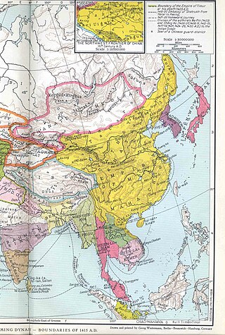
Manchuria under Ming rule refers to the domination of the Ming dynasty of China over the greater region of Manchuria, including today's Northeast China and Outer Manchuria. The Ming rule of Manchuria began with its conquest of Manchuria in the late 1380s after the fall of the Mongol-led Yuan dynasty, and reached its peak in the early 15th century with the establishment of the Nurgan Regional Military Commission. With the dissolution of the Nurgan Regional Military Commission the Ming power waned considerably in Manchuria. Starting in the 1580s, Nurhaci, the Jianzhou Jurchen chieftain who had been a Ming vassal, began to take control of most of Manchuria over the next several decades, and in 1616 he established the Later Jin and openly renounced Ming overlordship with the Seven Grievances. The Qing dynasty established by his son Hong Taiji would eventually conquer the Ming and take control of China proper.

<span class="mw-page-title-main">Manchuria under Qing rule</span>

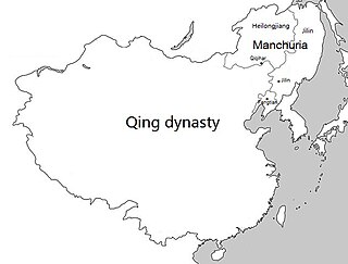
Manchuria under Qing rule was the rule of the Qing dynasty of China over the greater region of Manchuria, including today's Northeast China and Outer Manchuria, although Outer Manchuria was lost to the Russian Empire after the Amur Annexation. The Qing dynasty itself was established by the Manchus, a Tungusic people from Manchuria, who later replaced the Ming dynasty as the ruling dynasty of China. Thus, the region is often seen to have had a special status during the Qing and was not governed as regular provinces until the late Qing dynasty, although the name "Manchuria" itself is an exonym of Japanese origin and was not used by the Qing dynasty in Chinese or Manchu.

References

  1. Aihui Town on Google Maps
  2. 1 2 Амурская область: История НАРОДЫ АМУРСКОЙ ЗЕМЛИ Archived 2011-07-18 at the Wayback Machine (Amur Oblast - the History. The peoples of the Amur Land) (in Russian)
  3. Du Halde, Jean-Baptiste (1735). Description géographique, historique, chronologique, politique et physique de l'empire de la Chine et de la Tartarie chinoise. Vol. IV. Paris: P.G. Lemercier. pp. 15–16. Numerous later editions are available as well, including one on Google Books. Du Halde refers to the Yongle-era fort, the predecessor of Aigun, as Aykom. There seem to be few, if any, mentions of this project in other available literature.
  4. Bruce Mancall, Russia and China: Their Diplomatic Relations to 1728, 1971, pages 115-127.
  5. 1 2 E.G.Ravenstein, The Russians on the Amur. London, 1861. Full text can be found on Google Books. Pages 18,48.
  6. The Jesuits (at du Halde, pp. 18-19), who visited the "new" Aigun ca. 1709, also mentioned the old site on the left bank of the river (which they called Aykom), but said that it was 13 li (unit), i.e. some 8.3 km, upstream from the new site. They also claimed that Aykom was founded by the 15th-century Ming dynasty Yongle Emperor, but abandoned within 20 years. Although Yongle's Amur expeditions are well known (see e.g. Yishiha), there seem to be no corroboration in modern literature for the existence of a Yongle-era fort at the Old Aigun site.
  7. 1 2 Jean-Baptiste Du Halde, Description géographique, historique, chronologique, politique, et physique de l'empire de la Chine et de la Tartarie chinoise, enrichie des cartes générales et particulieres de ces pays, de la carte générale et des cartes particulieres du Thibet, & de la Corée; & ornée d'un grand nombre de figures & de vignettes gravées en tailledouce, Vol. 4 (La Haye: H. Scheurleer, 1736). Pp. 18-19.
  8. Edmonds, Richard Louis (1985). Northern Frontiers of Qing China and Tokugawa Japan: A Comparative Study of Frontier Policy. University of Chicago, Department of Geography; Research Paper No. 213. pp. 115–117. ISBN   0-89065-118-3.
  9. Jean-Baptiste Du Halde, Description géographique, historique, chronologique, politique, et physique de l'empire de la Chine et de la Tartarie chinoise, enrichie des cartes générales et particulieres de ces pays, de la carte générale et des cartes particulieres du Thibet, & de la Corée; & ornée d'un grand nombre de figures & de vignettes gravées en tailledouce, Vol. 1 (La Haye: H. Scheurleer, 1736). (p. xxxviii in Vol. 1)
  10. 1 2 Chisholm, Hugh, ed. (1911). "Aigun"  . Encyclopædia Britannica . Vol. 1 (11th ed.). Cambridge University Press. p. 437.
  11. SHIROKOGOROFF, S. M. (1934). "Reading and Transliteration of Manchu Lit.". Archives polonaises d'etudes orientales, Volumes 8-10. Contributors Polskie Towarzystwo Orientalistyczne, Polska Akademia Nauk. Komitet Nauk Orientalistycznych. Państwowe Wydawn. Naukowe. p. 122. Retrieved 25 August 2014.
  12. SHIROKOGOROFF, S. M. (1934). "Reading and Transliteration of Manchu Lit.". Rocznik orientalistyczny, Volumes 9-10. Contributors Polskie Towarzystwo Orientalistyczne, Polska Akademia Nauk. Komitet Nauk Orientalistycznych, Polska Akademia Nauk. Zakład Orientalistyki. p. 122. Retrieved 25 August 2014.
  13. 爱辉区概况 Archived 2012-12-25 at the Wayback Machine (Aihui District overview) (in Chinese)
  14. "Aihui History Museum" . Retrieved 2020-11-27.