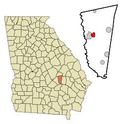
Ailey, Georgia | |
---|---|
Coordinates: 32°11′14″N82°34′8″W / 32.18722°N 82.56889°W | |
Country | United States |
State | Georgia |
County | Montgomery |
Area | |
• Total | 2.18 sq mi (5.64 km2) |
• Land | 2.16 sq mi (5.59 km2) |
• Water | 0.02 sq mi (0.05 km2) |
Elevation | 249 ft (76 m) |
Population | |
• Total | 519 |
• Density | 240.39/sq mi (92.82/km2) |
Time zone | UTC-5 (Eastern (EST)) |
• Summer (DST) | UTC-4 (EDT) |
ZIP code | 30410 |
Area code | 912 |
FIPS code | 13-00828 [3] |
GNIS feature ID | 0310413 [4] |
Ailey is a city in Montgomery County, Georgia, United States. As of the 2020 census, the city had a population of 519, [2] up from 432 in 2010.
A post office called Ailey was established in 1891. [5] The town incorporated in 1893. [6]
Ailey is located in western Montgomery County at 32°11′14″N82°34′8″W / 32.18722°N 82.56889°W (32.187181, -82.568932). [7] It is bordered to the west by Mount Vernon, the county seat. U.S. Route 280 passes through Ailey, leading west through Mount Vernon 23 miles (37 km) to McRae–Helena and east 10 miles (16 km) to Vidalia.
According to the United States Census Bureau, the city of Ailey has a total area of 2.2 square miles (5.7 km2), of which 0.02 square miles (0.05 km2), or 0.92%, are water. [1] The city is drained by tributaries of the Oconee River.
Climate data for Ailey, Georgia | |||||||||||||
---|---|---|---|---|---|---|---|---|---|---|---|---|---|
Month | Jan | Feb | Mar | Apr | May | Jun | Jul | Aug | Sep | Oct | Nov | Dec | Year |
Mean daily maximum °F (°C) | 60.4 (15.8) | 64.3 (17.9) | 70.7 (21.5) | 78.6 (25.9) | 85.6 (29.8) | 90.7 (32.6) | 92.7 (33.7) | 91.6 (33.1) | 87.0 (30.6) | 79.5 (26.4) | 70.3 (21.3) | 62.9 (17.2) | 77.9 (25.5) |
Mean daily minimum °F (°C) | 37.1 (2.8) | 38.9 (3.8) | 44.3 (6.8) | 52.4 (11.3) | 60.3 (15.7) | 66.5 (19.2) | 69.8 (21.0) | 69.3 (20.7) | 64.5 (18.1) | 54.2 (12.3) | 44.4 (6.9) | 38.6 (3.7) | 53.4 (11.9) |
Average precipitation inches (mm) | 4.4 (110) | 4.2 (110) | 4.7 (120) | 3.2 (81) | 3.8 (97) | 4.2 (110) | 4.8 (120) | 5.4 (140) | 3.6 (91) | 2.4 (61) | 2.5 (64) | 3.5 (89) | 46.5 (1,180) |
Source: Weatherbase [8] |
Census | Pop. | Note | %± |
---|---|---|---|
1900 | 271 | — | |
1910 | 306 | 12.9% | |
1920 | 385 | 25.8% | |
1930 | 428 | 11.2% | |
1940 | 506 | 18.2% | |
1950 | 508 | 0.4% | |
1960 | 469 | −7.7% | |
1970 | 487 | 3.8% | |
1980 | 579 | 18.9% | |
1990 | 579 | 0.0% | |
2000 | 394 | −32.0% | |
2010 | 432 | 9.6% | |
2020 | 519 | 20.1% | |
U.S. Decennial Census [9] 1850-1870 [10] 1880 [11] 1890-1910 [12] 1920-1930 [13] 1930-1940 [14] 1940-1950 [15] 1960-1980 [16] 1980-2000 [17] |
In 2020, the city had a resident population of 519.
Montgomery County is a county located in the central portion of the U.S. state of Georgia. As of the 2020 census, the population was 8,610. The county seat is Mount Vernon. Montgomery County is part of the Vidalia, GA micropolitan statistical area.
Wheeler County is a county located in the central portion of the U.S. state of Georgia. As of the 2020 census, the population was 7,471. The county seat is Alamo. The county is one of the most impoverished counties in the nation. The American Community Survey's 2009–2013 average reports that the county's per-capita income of $8,948 makes it the poorest county in the United States by this metric. The measurement however is misleading as Wheeler County is the site of Wheeler Correctional Facility, a large prison with a capacity of 2,874 prisoners, about 40 percent of the county's total population. Most prisoners have little income. The prison was opened in 1998 and the prison population may also account for the increased population of the county in the early 2000s.
Treutlen County is a county located in the east central portion of the U.S. state of Georgia. As of the 2020 census, the population was 6,406. The county seat is Soperton. It is host to the Million Pines Arts and Crafts Festival which occurs during the first weekend in November.
Toombs County is a county located in the east central portion of the U.S. state of Georgia. As of the 2020 census, the population was 27,030. The county seat is Lyons and the largest city is Vidalia. The county was created on August 18, 1905.
Emanuel County is a county located in the U.S. state of Georgia. As of the 2020 census, the population was 22,768. The county seat is Swainsboro.
Alma is a city in Bacon County, Georgia, United States, and the county seat. As of the 2020 census, the city had a population of 3,433.
Allentown is a city in Bleckley, Laurens, Twiggs, and Wilkinson counties in the U.S. state of Georgia, primarily in Wilkinson County. As of the 2010 census, the city had a population of 169, down from 287 at the 2000 census. In 2020, its population was 195. The Twiggs County portion is part of the Macon metropolitan statistical area, while the Laurens County portion is part of the Dublin micropolitan statistical area. The remaining Wilkinson and Bleckley County portions are not part of any metropolitan or micropolitan area.
Midville is a city in Burke County, Georgia, United States. The population was 269 at the 2010 census, and 385 in 2020. It is part of the Augusta, Georgia metropolitan area.
Sardis is a city in Burke County, Georgia, United States. The population is 995 in 2020. It is part of the Augusta, Georgia metropolitan area in the Central Savannah River Area (CSRA).
Vidette is a city in Burke County, Georgia, United States. The population was 103 in 2020. It is part of the Augusta, Georgia metropolitan area.
Adel is a city in and the county seat of Cook County, Georgia, United States, located fifty-two miles (84 km) southeast of Albany. As of the 2020 census, the city had a population of 5,571.
Adrian is a city in Emanuel and Johnson County, Georgia, United States. As of the 2020 census, the city had a population of 552.
Oglethorpe is a city in Macon County, Georgia, United States. The population was 995 at the 2020 census, down from 1,328 in 2010. The city is the county seat of Macon County. It was named for Georgia's founder, James Oglethorpe.
Alston is a town in Montgomery County, Georgia, United States, with a population of 178 at the 2020 census.
Mount Vernon is a city in, and the county seat of, Montgomery County, Georgia, United States. The population was 1,900 at the 2020 census, down from 2,451 in 2010. It is home to Brewton–Parker College.
Uvalda is a city in Montgomery County, Georgia, United States. The population was 439 at the 2020 census, down from 598 in 2010.
Woodland is a city in Talbot County, Georgia, United States. The population was 408 at the 2010 census.
LaFayette is a city in, and the county seat of, Walker County, Georgia, United States. As of the 2020 census, the city population was 6,888. It was founded as Chattooga.
Alamo is a city in Wheeler County, Georgia, United States. As of the 2020 census, the city had a population of 771. The city is the county seat of Wheeler County.
Abbeville is a city in Wilcox County, Georgia, United States. Per the 2020 census, the population was 2,685. The city is the county seat of Wilcox County.