
The Conemaugh River is a 70-mile (110 km) tributary of the Kiskiminetas River in Westmoreland, Indiana, and Cambria counties in the U.S. state of Pennsylvania. The name means 'Otter Creek', originating from the Unami-Lenape language word kwənəmuxkw 'otter'.
Loyalhanna Creek is a 50-mile (80 km) long tributary of the Kiskiminetas River in Westmoreland County in the U.S. state of Pennsylvania. The stream is a popular destination for canoeing and recreational trout fishing.

Brandywine Creek is a tributary of the Christina River in southeastern Pennsylvania and northern Delaware in the United States. The Lower Brandywine is 20.4 miles (32.8 km) long and is a designated Pennsylvania Scenic River with several tributary streams. The East Branch and West Branch of the creek originate within 2 miles (3 km) of each other on the slopes of Welsh Mountain in Honey Brook Township, Pennsylvania, about 20 miles (32 km) northwest of their confluence.

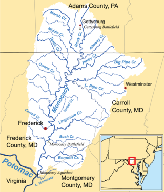
The Monocacy River is a free-flowing left tributary to the Potomac River, which empties into the Atlantic Ocean via the Chesapeake Bay. The river is 58.5 miles (94.1 km) long, with a drainage area of about 970 square miles (2,500 km2). It is the largest Maryland tributary to the Potomac.
Middle Creek is a 17.1-mile-long (27.5 km) tributary of Toms Creek in Pennsylvania and Maryland in the United States.

Conewago Creek is an 80.2-mile-long (129.1 km) tributary of the Susquehanna River in Adams and York counties in Pennsylvania in the United States, with its watershed also draining a small portion of Carroll County, Maryland. The source is at an elevation of 1,440 feet (440 m), east of Caledonia State Park, in Franklin Township in Adams County. The mouth is the confluence with the Susquehanna River at York Haven in York County at an elevation of 259 feet (79 m).
Carroll Creek is an 8.3-mile-long (13.4 km) tributary of the Monocacy River in Frederick County, Maryland. The headwaters of the creek are located on the eastern slopes of Catoctin Mountain, southeast of Gambrill State Park. The stream runs roughly east through the city of Frederick to the Monocacy, which drains to the Potomac River. The Shawnee Indians, who called the Monocacy River Monnockkesey, named Carroll Creek Walkwaki Methtegui,.

Maryland Route 77 is a state highway in the U.S. state of Maryland. The state highway runs 20.74 miles (33.38 km) from MD 64 in Smithsburg east to MD 194 in Keymar. MD 77 is the main east–west highway of northern Frederick County. The state highway connects Thurmont with eastern Washington County via Foxville, which lies between South Mountain and Catoctin Mountain near Catoctin Mountain Park and Cunningham Falls State Park. MD 77 links Thurmont with western Carroll County through the communities of Graceham, Rocky Ridge, and Detour in the Monocacy River valley. MD 77 was constructed from Thurmont east to Detour in the 1920s and early 1930s. A disjoint section of MD 77 was built between Cavetown and Foxville in the late 1930s. The portions of the modern highway between Foxville and Thurmont and from Detour to Keymar were county highways until they were designated part of MD 77 in 1956. MD 77's western terminus was moved east to MD 64 in Smithsburg in 1960.

The Beaver and Erie Canal, also known as the Erie Extension Canal, was part of the Pennsylvania Canal system and consisted of three sections: the Beaver Division, the Shenango Division, and the Conneaut Division. The canal ran 136 miles (219 km) north–south near the western edge of the state from the Ohio River to Lake Erie through Beaver County, Lawrence County, Mercer County, Crawford County, and Erie County, Pennsylvania.

The Wiconisco Canal was a 19th century transportation waterway, about 12 miles (19 km) long, in Dauphin County in the U.S. state of Pennsylvania. Running along the east bank of the Susquehanna River between Millersburg and Duncan's Island at the mouth of the Juniata River, the canal overcame about 42 feet (13 m) of vertical lift through the use of 7 locks.
The Codorus Navigation Company, based in York in south-central Pennsylvania, was formed in 1829 to make a navigable waterway along Codorus Creek from York, Pennsylvania, to the Susquehanna River, a distance of 11 miles (18 km). Plans called for 3 miles (4.8 km) of canal, 8 miles (12.9 km) of slack-water pools, 10 dams, and 13 locks with an average lift of about 7 feet (2.1 m).
The Susquehanna and Tidewater Canal between Wrightsville, Pennsylvania, and Havre de Grace, Maryland, at the head of Chesapeake Bay, provided an interstate shipping alternative to 19th-century arks, rafts, and boats plying the difficult waters of the lower Susquehanna River. Built between 1836 and 1840, it ran 43 miles (69 km) along the west bank of the river and rendered obsolete an older, shorter canal along the east bank. Of its total length, 30 miles (48 km) were in Pennsylvania and 13 miles (21 km) in Maryland. Although rivalry between Philadelphia, Pennsylvania, and Baltimore, Maryland, delayed its construction, the finished canal brought increased shipments of coal and other raw materials to both cities from Pennsylvania's interior. Competition from railroads was a large factor in the canal's decline after 1855. Canal remnants, including a lock keeper's house, have been preserved in Maryland, and locks 12 and 15 have been preserved in Pennsylvania.
Linganore Creek is a 13.5-mile-long (21.7 km) tributary of the Monocacy River in Frederick County, Maryland. The stream is formed from the confluence of the north and south forks of the Linganore, about 10 miles (16 km) east-northeast of the city of Frederick. The creek runs roughly southwest to the Monocacy River, which drains to the Potomac River. The watershed area of the creek is 83.1 square miles (215 km2). High water in the creek can result in flooding of Gas House Pike, an east–west road running between Monocacy Boulevard and Green Valley Road.
Harney is an unincorporated community in Carroll County, Maryland, United States. Harney is also the home of the 'World's Best Carnival'. It has been the home of the Harney Volunteer Fire Company since 1951.
Double Pipe Creek, sometimes called Pipe Creek, is a major tributary of the Monocacy River in Carroll County and Frederick County in Maryland, located several miles north and west of Westminster. The creek is only 1.6 miles (2.6 km) long, but is formed by the confluence of two much longer streams, Big Pipe Creek and Little Pipe Creek.
Tuscarora Creek is a 7.7-mile-long (12.4 km) tributary of the Monocacy River in Frederick County, Maryland, in the United States.
Toms Creek is a 20.8-mile-long (33.5 km) tributary of the Monocacy River in Pennsylvania and Maryland in the United States. Via the Monocacy River, it is part of the Potomac River watershed, flowing to Chesapeake Bay and the Atlantic Ocean.

The Tapeworm Railroad was a railway line planned by Congressman Thaddeus Stevens and nicknamed by opponents ridiculing a lengthy serpentine section around the Green Ridge of South Mountain after an orator compared the path to a tapeworm depiction on a product's packaging. Switchbacks were planned on the west slope at Hughs Forge along the E Br Antietam Creek and on the east slope at Stevens' 1822 Maria Furnace along Toms Creek, with three east slope tunnels through spurs of Jacks Mountain.
The Starners Dam Bridge is a steel stringer bridge over Alloway Creek on Baptist Road in Taneytown, Carroll County, Maryland, USA. It is also called Alloway Creek Bridge.

