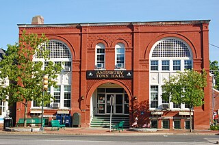
Amesbury is a city in Essex County, Massachusetts, United States, located on the left bank of the Merrimack River near its mouth, upstream from Salisbury and across the river from Newburyport and West Newbury. The population was 17,366 at the 2020 United States Census. A former farming and mill town, Amesbury is today largely residential. It is one of the two northernmost towns in Massachusetts.

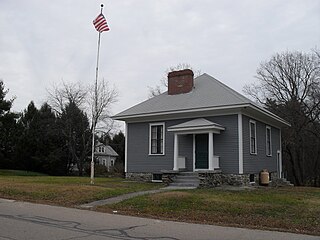
The Macy–Colby House is a historically significant saltbox house at 257 Main Street in Amesbury, Massachusetts. It is a historic house museum and has been listed on the National Register of Historic Places since 2008. In addition to its great age, it is notable for its association with Thomas Macy, an early settler of Nantucket and the subject of a poem by John Greenleaf Whittier, and for its long association with the locally significant Colby family.
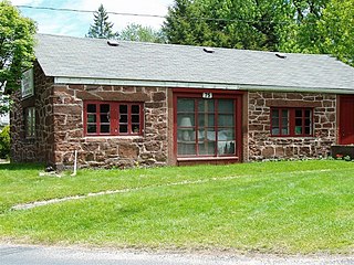
Ironstone is an historic village,, in the township of Uxbridge, Massachusetts, United States. It derived its name from plentiful bog iron found here which helped Uxbridge to become a center for three iron forges in the town's earliest settlement. South Uxbridge has historic sites, picturesque weddings, hospitality, industrial and distribution centers, and the new Uxbridge High School. This community borders North Smithfield, and Burrillville, Rhode Island, and Millville, Massachusetts. South Uxbridge receives municipal services from Uxbridge, for fire, police, EMS, School district, public works, and other services. There is a South Uxbridge fire station of the Uxbridge fire department. Worcester's Judicial District includes Uxbridge District Court. Ironstone appears on the Blackstone U.S. Geological Survey Map. Worcester County is in the Eastern time zone and observes DST.

The Bemis Mill is a historic former industrial building at 1-3 Bridge Street, in the village of Nonantum, in Newton, Massachusetts. It is now a general office building called the Meredith Building. The building is significant historically as a surviving early industrial building in the city, and for the remnants of unique power distribution and water control facilities that survive. On September 4, 1986, it was added to the National Register of Historic Places.

Saylesville is a village and historic district in Lincoln, Rhode Island.
The Linwood Historic District is an industrial historic district in the Linwood village of Northbridge, Massachusetts. It is the site of the Linwood Cotton Mill and is roughly bounded by Linwood Avenue, Maple Court, and Pine Court. On June 16, 1989, it was added to the National Register of Historic Places.
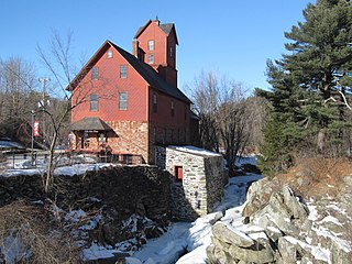
The Somersville Historic District encompasses the historic components of the mill village of Somersville in western Somers, Connecticut, United States. The district is centered on a mill complex on the Scantic River, which divides the district. The most significant years of development were between about 1835 and 1935, although the area has a history dating to the 1760s. The district was listed on the National Register of Historic Places in 1995. The Mill itself has since burned down and as of October 2018 is currently open field, although the canal structure remains in place.

The Hotchkissville Historic District is a historic district in the town of Woodbury, Connecticut, that was listed on the National Register of Historic Places in 1995. The district encompasses most of the historic village of Hotchkissville, which is centered at the junction of Washington and Weekeepeemee roads. The village began as a dispersed rural agricultural community, but developed in the 19th century with the arrival of industry, primarily the manufacture of textiles. Despite this, the village has retained a significantly rural character, and includes a broad cross-section of 18th- and 19th-century architectural styles.

The Whitinsville Historic District is a historic district on Church, East, Fletcher, Hill, Woodland, Lake, and Water Sts., Castle Hill Rs., and Linwood Avenue in Northbridge, Massachusetts. The district encompasses the historic 19th century mill village of Whitinsville, which grew up around an 1826 brick mill building erected by Paul Whitin. The Whitin family came to dominate the textile trade in Northbridge, with numerous mill complexes.

The Mill Village Historic District is a historic district encompassing a well-preserved 19th century mill village in Williamstown, Massachusetts. It is located on Cole Avenue and other streets east of Cole and south of the Hoosac River, which provided the mill's power. The complex dates to the mid-19th century, and includes tenement houses, housing for supervisors and specialty personnel, as well as a surviving mill building. The village district was listed on the National Register of Historic Places in 1983.

The Arlington Mills Historic District encompasses a major 19th century textile manufacturing complex in Lawrence and Methuen, Massachusetts. Developed between 1865 and 1925, it was one of the state's largest textile operations at its height. At the time of its listing on the National Register of Historic Places in 1985, the mill complex was owned by Malden Mills.

The Merrimack Valley is a bi-state region along the Merrimack River in the U.S. states of New Hampshire and Massachusetts. The Merrimack is one of the larger waterways in New England and has helped to define the livelihood and culture of those living along it for millennia.

The Carroll Building in Norwich, Connecticut, also known as the Flat Iron Building, was built in 1887. It was listed on the National Register of Historic Places (NRHP) in 1982. It is included in the Downtown Norwich Historic District, which is also listed on the NRHP. Originally used as offices and retail stores, the building is now currently used primarily as an apartment building. The Carroll Building is located on a triangular tract created by the intersection of Main and Water Streets. The building is highly visible from Washington Square and is one of the most noticeable aspects of the downtown streetscape. The building is currently vacant.
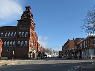
The Suncook Village Commercial–Civic Historic District encompasses the civic and commercial heart of Suncook, New Hampshire, a village on the Suncook River in Pembroke and Allenstown. The civic district is a 3-acre (1.2 ha) area on the Pembroke side of the river, adjacent to the Pembroke Mill, a site that had seen industrial use since the 18th century. The district includes 21 commercial buildings, 19 of which are historically significant. The district was listed on the National Register of Historic Places in 2005.

The Jewell Town District of South Hampton, New Hampshire, encompasses a colonial-era industrial village with a history dating to 1687. It is centered at the junction of West Whitehall and Jewell Streets, which is just south of a bend in the Powwow River, the source of the power for the mills that were built here. The area was settled in 1687 by Thomas Jewell, and by the early 19th century included a variety of mills as well as a bog iron works. The district now includes only remnants of its industrial past, and features a collection of 18th and early-19th century residential architecture. The district was listed on the National Register of Historic Places in 1983.

Blackstone River Valley National Historical Park is a National Park Service unit in the states of Rhode Island and Massachusetts. The park was created for the purpose of preserving, protecting, and interpreting the industrial heritage of the Blackstone River Valley and the urban, rural, and agricultural landscape of that region. The Blackstone River Valley was the site of some of the earliest successful textile mills in the United States, and these mills contributed significantly to the earliest American Industrial Revolution. The subsequent construction of the Blackstone Canal, a few years after the successful completion of the Erie Canal, helped to sustain the region's industrial strength.
The Jericho Village Historic District encompasses the historic industrial and commercial center of the village of Jericho, Vermont. Stretched along Vermont Route 15 south of Browns River, which powered the village's industries for many years, the village center includes a well-preserved array of 19th and early 20th-century buildings. The district was listed on the National Register of Historic Places in 1992.

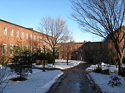
The Briggs Carriage Company is a historic industrial complex at 14 and 20 Cedar Street in Amesbury, Massachusetts. Built before 1890, these two buildings are a surviving reminder of the city's late 19th century prominence as a major carriage manufacturing center. They were listed on the National Register of Historic Places in 2007.

The Manchaug Village Historic District is a historic district encompassing the 19th century industrial village center of Manchaug in Sutton, Massachusetts. Developed in the 1820s around textile mills on the Mumford River, it was the largest industrial area in Sutton, with at least three mill complexes in operation. The district is centered on the junction of Main Street with Manchaug, Putnam Hill, and Whitins Roads.