Anderson, South Dakota | |
|---|---|
 Anderson, South Dakota  Anderson, South Dakota | |
| Coordinates: 43°30′59″N96°37′41″W / 43.51639°N 96.62806°W | |
| Country | United States |
| State | South Dakota |
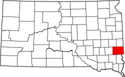
| County | Minnehaha |
| Area | |
• Total | 0.77 sq mi (1.98 km2) |
| • Land | 0.77 sq mi (1.98 km2) |
| • Water | 0.00 sq mi (0.00 km2) |
| Elevation | 1,450 ft (440 m) |
| Population | |
• Total | 388 |
| • Density | 506.53/sq mi (195.68/km2) |
| Time zone | UTC-6 (Central (CST)) |
| • Summer (DST) | UTC-5 (CDT) |
| Area code | 605 |
| GNIS feature ID | 2584543 [2] |
Anderson, also known as Anderson Subdivision, is an unincorporated community and census-designated place in Minnehaha County, South Dakota, United States. Its population was 388 as of the 2020 census. [4] The community is east of Sioux Falls.