Angelus, Kansas | |
---|---|
Coordinates: 39°11′28″N100°41′04″W / 39.19111°N 100.68444°W [1] | |
Country | United States |
State | Kansas |
County | Sheridan |
Elevation | 2,930 ft (890 m) |
Time zone | UTC-6 (CST) |
• Summer (DST) | UTC-5 (CDT) |
Area code | 785 |
FIPS code | 20-01825 [1] |
GNIS ID | 471308 [1] |
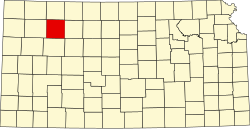
Angelus is an unincorporated community in Sheridan County, Kansas, United States. [1] It is located in Solomon Township, approximately 20 miles southwest of Hoxie. Also, it is located northwest of Grinnell and Interstate 70.
A post office was opened in Angelus in 1894, and remained in operation until it was discontinued in 1911. [2]
As of 1910, the community had a population of 30 and was a local trading center, with the nearest train stations in either Grinnell or Campus to the south in Gove County. [3]
According to a history prepared by Fr. Menig of the Angelus parish church in 1937, the community was founded by residents of Saint Bernard, Nebraska who were looking for less expensive, though still good, land for farming. The first settlers arrived in late 1887. St. Paul's church was founded at that time, and had 49 members by 1888. The community was named Angelus in 1892 by Rev. J. Disselkamp, the pastor of the church in Colby, Kansas which serviced the area. The church grew to 92 families and 588 members by 1937, and the community's Catholic school run by the Sisters of the Precious Blood had 80 students. [4] A 1987 story on the community's 100th anniversary noted that "Angelus never really became a town, but was merely a community that grew up around its church." By that time, the community's earlier two grocery stores, three garages/gas stations, and all other businesses, had closed, leaving only the church, school, and a few homes. [5]
Though there are not current formal population measures of Angelus, Solomon Township had a population of 179 in the 2010 census.
Sheridan County is a county located in the U.S. state of Kansas. Its county seat is Hoxie. As of the 2020 census, the county population was 2,447. The county was named in honor of Phillip Sheridan, a general during the American Civil War.
Marion County is a county located in the U.S. state of Kansas. Its county seat is Marion and its most populous city is Hillsboro. As of the 2020 census, the county population was 11,823. The county was named in honor of Francis Marion, a brigadier general of the American Revolutionary War, known as the "Swamp Fox".
Graham County is a county located in the U.S. state of Kansas. Its county seat and most populous city is Hill City. As of the 2020 census, the county population was 2,415. The county was named for John Graham, a captain in the American Civil War that died during the Battle of Chickamauga. The county is home to Nicodemus, founded 1877, which is the only remaining western town established by African Americans during the Reconstruction Period following the American Civil War.
Gove County is a county in the U.S. state of Kansas. Its county seat is Gove City, and its most populous city is Quinter. As of the 2020 census, the county population was 2,718. The county was named for Granville Gove, a captain of Company G of the 11th Kansas Cavalry Regiment Volunteer Cavalry, who died from battle wounds during the American Civil War.
Sheridan is a village in LaSalle County, Illinois, United States. As of the 2020 census, the village's population was 2,431, up from 2,137 at the 2010 census. It is part of the Ottawa Micropolitan Statistical Area.
Elbing is a city in Butler County, Kansas, United States. It is named after the city Elbląg in northern Poland, formerly Prussia. As of the 2020 census, the population of the city was 226. It is located about 10.7 miles east of Interstate 135 in Newton, along the Union Pacific Railroad.
Beloit is a city in and the county seat of Mitchell County, Kansas, United States. As of the 2020 census, the population of the city was 3,404.
Auburn is a city in Shawnee County, Kansas, United States. As of the 2020 census, the population of the city was 1,273.
Holton Township is a civil township of Muskegon County in the U.S. state of Michigan. As of the 2000 census, the township population was 2,532.
Angelus Oaks is an unincorporated community in San Bernardino County, California, United States, and has a population of 535 as of the 2010 U.S. Census, up from an estimated population of 312 in 2000. It is surrounded by the San Bernardino National Forest and located east of San Bernardino on California State Route 38.
Nicodemus is an unincorporated community in Graham County, Kansas, United States. As of the 2020 census, the population of the community and nearby areas was 14. The community was founded in 1877 and is named for the Biblical figure Nicodemus.
Tecumseh is an unincorporated community in Shawnee County, Kansas, United States, and situated along the Kansas River. As of the 2020 census, the population of the community and nearby areas was 696. The community and township are both named for the Shawnee chief.
Carlyle is an unincorporated community in Allen County, Kansas, United States.
Cecil Township is a civil township in Bottineau County in the U.S. state of North Dakota. As of the 2000 census, its population was 28.
Solomon Township is a township in Sheridan County, Kansas, United States. As of the 2010 Census, it had a population of 179.
Seguin is an unincorporated community in Sheridan County, Kansas, United States. It is located in Logan Township, approximately 10 miles west of Hoxie. It lies south of U.S. Route 24, to which it is linked by Kansas Highway 188.
Studley is an unincorporated community in Sheridan County, Kansas, United States, approximately 16 miles east of Hoxie along U.S. Route 24. It is on the eastern edge of the county in Valley Township, bordering Graham County. It was named after the Studley Royal Park, in England.
Webster was an unincorporated community in Belmont Township, Rooks County, Kansas, United States.
Chicago is a ghost town in Adell Township, Sheridan County, Kansas, United States.
Tasco is an unincorporated community in Sheridan County, Kansas, United States. It is located about 7 miles east of Hoxie and south of U.S. Route 24 highway, next to an abandoned railroad.