
The Arctic Archipelago, also known as the Canadian Arctic Archipelago, is an archipelago lying to the north of the Canadian continental mainland, excluding Greenland and Iceland.
This is a list of the extreme points of the United Kingdom: the points that are farther north, south, east or west than any other location. Traditionally the extent of the island of Great Britain has stretched "from Land's End to John o' Groats".
The Forrestal Range is a largely snow-covered mountain range, about 65 nautical miles long, standing east of Dufek Massif and the Neptune Range in the Pensacola Mountains, Antarctica.
The Patuxent Range is a major range of the Pensacola Mountains, Antarctica. It comprises the Thomas Hills, Anderson Hills, Mackin Table and various nunataks and ridges bounded by the Foundation Ice Stream, Academy Glacier and the Patuxent Ice Stream.
Enchi is a town in Ghana. It is the capital of the Aowin Municipality. Other main towns in the Aowin District include Old and New Yakasi, Achimfo, Boinso, Jema, Omanpe, Sewum, Jensue, Yiwabra, Yiwabra Nkwanta, Nyankomam, Kwawu, Abochia, and Jomoro. The largest river in the district is the Tano whose tributary, the Desue (Disue), flows in the middle of Enchi.
Pedro Bank is a large bank of sand and coral, partially covered with seagrass, about 80 km south and southwest of Jamaica, rising steeply from a seabed of 800 metres depth. It slopes gently from the Pedro Cays to the west and north with depths from 13 to 30 metres. The total area of the bank within the 100-metre (328-foot) isobath measures 8,040 square kilometres. The area of a depth to 40 metres is triangular, 70 kilometres long east-west, and 43 kilometres wide. 2,400 square kilometres are less than 20 metres deep. With its islets, cays and rocks, a total land area of 270,000 m2 (2,906,256 sq ft), it is the location of one of the two offshore island groups of Jamaica, the other one being the Morant Cays. The bank is centered at 17°06′N78°20′W.
Kaluža is a village and municipality in Michalovce District in the Kosice Region of eastern Slovakia.
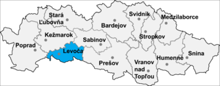
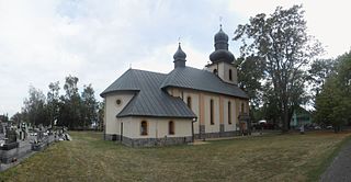
Granč-Petrovce is a village and municipality in Levoča District in the Prešov Region of central-eastern Slovakia.
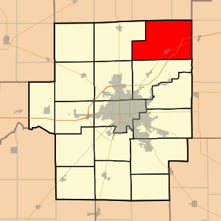
Friends Creek Township is located in Macon County, Illinois. As of the 2010 census, its population was 1,450 and it contained 601 housing units.
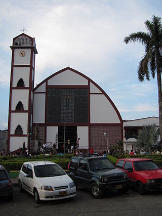
Belalcázar is a town and municipality in the Colombian Department of Caldas.
Aitkenhead Glacier is a 10 nautical miles long glacier flowing east-southeast from the Detroit Plateau, Graham Land, into Prince Gustav Channel.

German submarine U-420 was a Type VIIC U-boat built for the Kriegsmarine for service during World War II. She was laid down in the Danziger Werft as yard number 121, launched on 18 August 1942 and commissioned on 16 December the same year under Oberleutnant zur See Peter Högqvist. She then joined the 8th U-boat Flotilla for training before transferring to the 11th flotilla for operations.

Zambo is a department or commune of Ioba Province in south-eastern Burkina Faso. Its capital lies at the town of Zambo.
Goumsin is a town in the Kayao Department of Bazèga Province in central Burkina Faso. The town has a population of 2,247.
The Svendsen Peninsula is located on the southwestern coast of Ellesmere Island, a part of the Qikiqtaaluk Region of the Canadian territory of Nunavut. Much of it is shielded from Norwegian Bay by the Raanes Peninsula (northwest) and Bjorne Peninsula (southwest). The Svendsen Peninsula is notable for its many fiords, including Trold, Baumann, and Vendom. Gryte Bay is in the west. Hoved Island lies offshore.
Gougoudjé is a town and sub-prefecture in the Télimélé Prefecture in the Kindia Region of western-central Guinea.
Donja Pološnica is a village in the municipality of Kosjerić, western Serbia. According to the 2002 census, the village has a population of 97 people.
Kosco Glacier is a glacier about 20 nautical miles long, flowing from the Anderson Heights vicinity of the Bush Mountains of Antarctica northward to enter the Ross Ice Shelf between Wilson Portal and Mount Speed.

