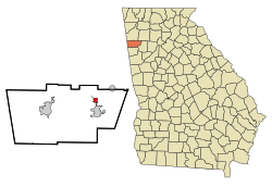
The City of Aragon | |
---|---|
Coordinates: 34°2′43″N85°3′27″W / 34.04528°N 85.05750°W | |
Country | United States |
State | Georgia |
County | Polk |
Established | December 1899 |
Government | |
• Type | Mayor-Council |
• Mayor | Judd Fee |
• Mayor Pro Tem | Donnie Canada |
• Council Member | Dickie Gazaway |
• Council Member | Stephan Sanders |
• Council Member | Ed Streetman |
Area | |
• Total | 1.11 sq mi (2.87 km2) |
• Land | 1.09 sq mi (2.82 km2) |
• Water | 0.02 sq mi (0.05 km2) |
Elevation | 741 ft (226 m) |
Population (2020) | |
• Total | 1,571 |
• Density | 1,323.53/sq mi (510.97/km2) |
Time zone | UTC-5 (Eastern (EST)) |
• Summer (DST) | UTC-4 (EDT) |
ZIP code | 30104 |
Area codes | 770/678/470 |
FIPS code | 13-02592 [2] |
GNIS feature ID | 0354383 [3] |
Aragon is a city in Polk County, Georgia, United States. As of the 2020 census, the city had a population of 1,440.
A post office has been in operation in Aragon since 1899. [4] The city was named for local deposits of the mineral aragonite. [5] Aragon incorporated in 1914. [6]
The city was home to Aragon mill which is now closed and abandoned [7] An EF3 tornado struck the northern part of the city on March 15, 2008, claiming two lives.
Aragon is located at 34°2′43″N85°3′27″W / 34.04528°N 85.05750°W (34.045252, -85.057384). [8]
According to the United States Census Bureau, the city has a total area of 2.82 square miles (7.3 km2), all land.
Census | Pop. | Note | %± |
---|---|---|---|
1950 | 1,272 | — | |
1960 | 1,023 | −19.6% | |
1980 | 855 | — | |
1990 | 899 | 5.1% | |
2000 | 1,039 | 15.6% | |
2010 | 1,249 | 20.2% | |
2020 | 1,440 | 15.3% | |
U.S. Decennial Census [9] 1850-1870 [10] 1870-1880 [11] 1890-1910 [12] 1920-1930 [13] 1940 [14] 1950 [15] 1960 [16] 1970 [17] 1980 [18] 1990 [19] 2000 [20] 2010 [21] 2020 [22] |
Aragon appeared as an unincorporated community in the 1950 U.S. Census [15] and the 1960 U.S. Census. [16] It was not listed in the 1970 U.S. Census. [17] In the 1980 U.S. Census it was listed as a city. [16]
Race / Ethnicity (NH = Non-Hispanic) | Pop 2000 [23] | Pop 2010 [21] | Pop 2020 [22] | % 2000 | % 2010 | 2020 |
---|---|---|---|---|---|---|
White alone (NH) | 1,003 | 1,076 | 1,148 | 96.54% | 86.15% | 79.72% |
Black or African American alone (NH) | 7 | 69 | 137 | 0.67% | 5.52% | 9.51% |
Native American or Alaska Native alone (NH) | 4 | 2 | 3 | 0.38% | 0.16% | 0.21% |
Asian alone (NH) | 1 | 7 | 7 | 0.10% | 0.56% | 0.49% |
Pacific Islander alone (NH) | 0 | 0 | 0 | 0.00% | 0.00% | 0.00% |
Some Other Race alone (NH) | 0 | 3 | 2 | 0.00% | 0.24% | 0.14% |
Mixed Race or Multi-Racial (NH) | 6 | 29 | 79 | 0.58% | 2.32% | 5.49% |
Hispanic or Latino (any race) | 18 | 63 | 64 | 1.73% | 5.04% | 4.44% |
Total | 1,039 | 1,249 | 1,440 | 100.00% | 100.00% | 100.00% |
As of the 2020 United States census, there were 1,440 people, 505 households, and 357 families residing in the city.
As of the census [2] of 2010 thru 2017, there were 1,252 people, 399 households, and 284 families residing in the city. The population density was 1150.15 people/mi2(444.07 people/km2). There were 474 housing units at an average density of 393.9 per square mile (152.1/km2). The racial makeup of the city was 97.21% White, 0.67% African American, 0.87% Native American, 0.10% Asian, 0.38% from other races, and 0.77% from two or more races. Hispanic or Latino of any race were 1.73% of the population.
There were 399 households, out of which 35.3% had children under the age of 18 living with them, 55.6% were married couples living together, 10.5% had a female householder with no husband present, and 28.6% were non-families. 23.3% of all households were made up of individuals, and 9.3% had someone living alone who was 65 years of age or older. The average household size was 2.60 and the average family size was 3.08.
In the city, the population was spread out, with 27.1% under the age of 18, 11.0% from 18 to 24, 29.1% from 25 to 44, 21.7% from 45 to 64, and 11.2% who were 65 years of age or older. The median age was 34 years. For every 100 females, there were 92.8 males. For every 100 females age 18 and over, there were 92.6 males.
The median income for a household in the city was $31,053, and the median income for a family was $39,167. Males had a median income of $28,250 versus $21,406 for females. The per capita income for the city was $15,084. About 11.0% of families and 17.5% of the population were below the poverty line, including 22.9% of those under age 18 and 11.1% of those age 65 or over.
Chambers County is a county located in the east central portion of the U.S. state of Alabama. As of the 2020 census the population was 34,772. Its county seat is LaFayette. Its largest city is Valley. Its name is in honor of Henry H. Chambers, who served as a United States Senator from Alabama.
Cherokee County, Alabama is a county located in the northeastern part of the U.S. state of Alabama. As of the 2020 census, the population was 24,971. Its county seat is Centre. The county is named for the Cherokee tribe.
Cleburne County is a county located in the east central portion of the U.S. state of Alabama. As of the 2020 census, the population was 15,056. Its county seat is Heflin. Its name is in honor of Patrick R. Cleburne of Arkansas who rose to the rank of major general in the Confederate States Army. The eastern side of the county borders the state of Georgia.
Walker County is a county in the Northwest region of the U.S. state of Georgia. As of the 2020 census, the population was 67,654, down from 68,756 in 2010. The county seat is LaFayette. The county was created on December 18, 1833, from land formerly belonging to the Cherokee Indian Nation. Walker County is part of the Chattanooga TN/GA Metropolitan Statistical Area.
Polk County is a county in the Northwest region of the U.S. state of Georgia. As of the 2020 census, the population was 42,853. The county seat is Cedartown. The county was created on December 20, 1851, by an act of the Georgia General Assembly and named after James K. Polk, the eleventh President of the United States. Polk County comprises the Cedartown, GA Metropolitan Statistical Area.
Floyd County is a county in the Northwest region of the U.S. state of Georgia. As of the 2020 United States Census, the population was 98,584. The county seat is Rome. Floyd County comprises the Rome, Georgia metropolitan statistical area.
Fannin County is a county in the Northwest region of the U.S. state of Georgia. As of the 2020 census, the population was 25,319. It is one of the most rural counties in Georgia due its location in the Appalachian Mountain Range, with about 90% of the population of Fannin County living in unincorporated lands. The county seat and largest city is Blue Ridge. The county was created on January 21, 1854, and is named after James Fannin, a veteran who fought in the Texas Revolution.
Dade County is a county in the U.S. state of Georgia. It occupies the northwest corner of Georgia, and the county's own northwest corner is the westernmost point in the state. As of the 2020 census, the population is 16,251. The county seat and only incorporated municipality is Trenton. Dade County is part of the Chattanooga, TN–GA Metropolitan Statistical Area. In 1860, residents of Dade County voted to secede from the state of Georgia and from the United States, but no government outside the county ever recognized this gesture as legal. In 1945, the county symbolically "rejoined" Georgia and the United States.
Polk County is a county located in the U.S. state of Arkansas. As of the 2020 census, the population was 19,221. The county seat is Mena. Polk County is Arkansas's 48th county, formed on November 30, 1844; it was named for James K. Polk, 11th President of the United States.
Lakeview is an unincorporated community and census-designated place (CDP) in Catoosa and Walker counties in the U.S. state of Georgia. The population was 4,820 at the 2000 census and 4,777 at the 2020 census. It is part of the Chattanooga, TN–GA Metropolitan Statistical Area.
Lindale is an unincorporated community and census-designated place (CDP) in Floyd County, Georgia, United States. It is part of the Rome, Georgia Metropolitan Statistical Area. The population was 4,191 at the 2010 census.
Union Point is a city in Greene County, Georgia, United States. As of the 2020 census, the city population was 1,597.
White Plains is a city in Greene County, Georgia, United States. The population was 284 at the 2010 census.
LaFayette is a city in, and the county seat of, Walker County, Georgia, United States. As of the 2020 census, the city population was 6,888. It was founded as Chattooga.
Lookout Mountain is a city entirely within Walker County, Georgia, United States. Bordering its sister town of Lookout Mountain, Tennessee, Lookout Mountain is part of the Chattanooga metropolitan statistical area. The population was 1,641 at the 2020 census. The city is located on Lookout Mountain, home to such attractions as Rock City. This city is often named as home to Covenant College, but the college is actually across the county line in Dade County.
Varnell is a city in Whitfield County, Georgia, United States. It is part of the Dalton, Georgia Metropolitan Statistical Area. The population was 2,179 at the 2020 census.
Polk City is a city in Polk County, Iowa, United States. The population was 5543 in the 2020 census, an increase from 2,344 in 2000. It is part of the Des Moines–West Des Moines Metropolitan Statistical Area.
Scissors is a census-designated place (CDP) in Hidalgo County, Texas, United States. The population was 3,758 at the 2020 United States Census. It is part of the McAllen–Edinburg–Mission Metropolitan Statistical Area.
Seven Oaks is a city in Polk County, Texas, United States. The population was 68 at the 2020 census.
Groveton is a city in Trinity County, Texas, United States. The population was 918 at the 2020 census. It is the county seat of Trinity County.