Aragon, Georgia

Last updated

The City of Aragon
Aragon, Georgia October 2016.jpg
Street in Aragon
Flag of Aragon, Georgia.png
Seal of Aragon, Georgia.png
Polk County Georgia Incorporated and Unincorporated areas Aragon Highlighted.svg
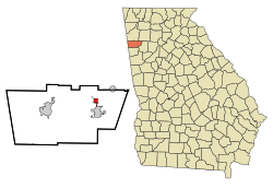
Location in Polk County and the state of Georgia
Coordinates: 34°2′43″N85°3′27″W / 34.04528°N 85.05750°W / 34.04528; -85.05750
Country United States
State Georgia
County Polk
EstablishedDecember 1899
Government
  TypeMayor-Council
  MayorJudd Fee
  Mayor Pro TemDonnie Canada
  Council MemberDickie Gazaway
  Council MemberStephan Sanders
  Council MemberEd Streetman
Area
[1]
  Total1.11 sq mi (2.87 km2)
  Land1.09 sq mi (2.82 km2)
  Water0.02 sq mi (0.05 km2)
Elevation
741 ft (226 m)
Population
 (2020)
  Total1,571
  Density1,323.53/sq mi (510.97/km2)
Time zone UTC-5 (Eastern (EST))
  Summer (DST) UTC-4 (EDT)
ZIP code
30104
Area codes 770/678/470
FIPS code 13-02592 [2]
GNIS feature ID0354383 [3]

Aragon is a city in Polk County, Georgia, United States. As of the 2020 census, the city had a population of 1,440.

Contents

History

A post office has been in operation in Aragon since 1899. [4] The city was named for local deposits of the mineral aragonite. [5] Aragon incorporated in 1914. [6]

The city was home to Aragon mill which is now closed and abandoned [7] An EF3 tornado struck the northern part of the city on March 15, 2008, claiming two lives.

Geography

Aragon is located at 34°2′43″N85°3′27″W / 34.04528°N 85.05750°W / 34.04528; -85.05750 (34.045252, -85.057384). [8]

According to the United States Census Bureau, the city has a total area of 2.82 square miles (7.3 km2), all land.

Demographics

Historical population
CensusPop.Note
1980 855
1990 9025.5%
2000 1,03915.2%
2010 1,24920.2%
2020 1,44015.3%
U.S. Decennial Census [9]

2020 census

Aragon racial composition [10]
RaceNum.Perc.
White (non-Hispanic)1,14879.72%
Black or African American (non-Hispanic)1379.51%
Native American 30.21%
Asian 70.49%
Other/Mixed 815.63%
Hispanic or Latino 644.44%

As of the 2020 United States census, there were 1,440 people, 505 households, and 357 families residing in the city.

2010 census

As of the census [2] of 2010 thru 2017, there were 1,252 people, 399 households, and 284 families residing in the city. The population density was 1150.15 people/mi2(444.07 people/km2). There were 474 housing units at an average density of 393.9 per square mile (152.1/km2). The racial makeup of the city was 97.21% White, 0.67% African American, 0.87% Native American, 0.10% Asian, 0.38% from other races, and 0.77% from two or more races. Hispanic or Latino of any race were 1.73% of the population.

There were 399 households, out of which 35.3% had children under the age of 18 living with them, 55.6% were married couples living together, 10.5% had a female householder with no husband present, and 28.6% were non-families. 23.3% of all households were made up of individuals, and 9.3% had someone living alone who was 65 years of age or older. The average household size was 2.60 and the average family size was 3.08.

In the city, the population was spread out, with 27.1% under the age of 18, 11.0% from 18 to 24, 29.1% from 25 to 44, 21.7% from 45 to 64, and 11.2% who were 65 years of age or older. The median age was 34 years. For every 100 females, there were 92.8 males. For every 100 females age 18 and over, there were 92.6 males.

The median income for a household in the city was $31,053, and the median income for a family was $39,167. Males had a median income of $28,250 versus $21,406 for females. The per capita income for the city was $15,084. About 11.0% of families and 17.5% of the population were below the poverty line, including 22.9% of those under age 18 and 11.1% of those age 65 or over.

Related Research Articles

<span class="mw-page-title-main">Cherokee County, Alabama</span> County in Alabama, United States

Cherokee County, Alabama is a county located in the northeastern part of the U.S. state of Alabama. As of the 2020 census, the population was 24,971. Its county seat is Centre. The county is named for the Cherokee tribe.

<span class="mw-page-title-main">Cleburne County, Alabama</span> County in Alabama, United States

Cleburne County is a county located in the east central portion of the U.S. state of Alabama. As of the 2020 census, the population was 15,056. Its county seat is Heflin. Its name is in honor of Patrick R. Cleburne of Arkansas who rose to the rank of major general in the Confederate States Army. The eastern side of the county borders the state of Georgia.

<span class="mw-page-title-main">Polk County, Georgia</span> County in Georgia, United States

Polk County is a county located in the northwestern part of the U.S. state of Georgia. As of the 2020 census, the population was 42,853. The county seat is Cedartown. The county was created on December 20, 1851, by an act of the Georgia General Assembly and named after James K. Polk, the eleventh President of the United States.

<span class="mw-page-title-main">Meriwether County, Georgia</span> County in Georgia, United States

Meriwether County is a county located in the west central portion of the U.S. state of Georgia. As of the 2020 census, the population was 20,613. The county seat is Greenville, home of the Meriwether County Courthouse. The county was formed on December 14, 1827, as the 73rd county in Georgia. It was named for David Meriwether, a general in the American Revolutionary War and member of Congress from Georgia.

<span class="mw-page-title-main">Hart County, Georgia</span> County in Georgia, United States

Hart County is a county located in the northeastern part of the U.S. state of Georgia. As of the 2020 census, the population was 25,828. The county seat is Hartwell.

<span class="mw-page-title-main">Floyd County, Georgia</span> County in Georgia, United States

Floyd County is a county located in the northwestern part of the U.S. state of Georgia. As of the 2020 United States Census, the population was 98,584. The county seat is Rome.

St. Mary's is a city in Kusilvak Census Area, Alaska, United States. The adjacent village of Andreafsky joined with St. Mary's in 1980. At the 2010 census the population was 507, up from 500 in 2000. By 2018, the population was estimated to be 567.

<span class="mw-page-title-main">Fort Oglethorpe, Georgia</span> City in Georgia, United States

Fort Oglethorpe is a city predominantly in Catoosa County with some portions in Walker County in the U.S. state of Georgia. As of the 2020 census, the city had a population of 10,423. It is part of the Chattanooga, TN–GA Metropolitan Statistical Area. It is home to Lakeview – Fort Oglethorpe High School.

<span class="mw-page-title-main">Plainville, Georgia</span> City in Georgia, United States

Plainville is a city located in Gordon County, Georgia. The population of Plainville was 313 at the 2010 census, up from 257 at the 2000 census.

<span class="mw-page-title-main">Tallapoosa, Georgia</span> City in Georgia, United States

Tallapoosa is a city in Haralson County, Georgia. The population was 3,170 at the 2010 census, up from 2,789 at the 2000 census.

<span class="mw-page-title-main">LaFayette, Georgia</span> City in Georgia, United States

LaFayette is a city in, and the county seat of, Walker County, Georgia, United States. As of the 2020 census, the city population was 6,888. It was founded as Chattooga.

<span class="mw-page-title-main">Lookout Mountain, Georgia</span> City in Georgia, United States

Lookout Mountain is a city entirely within Walker County, Georgia, United States. Bordering its sister town of Lookout Mountain, Tennessee, Lookout Mountain is part of the Chattanooga metropolitan statistical area. The population was 1,641 at the 2020 census. The city is located on Lookout Mountain, home to such attractions as Rock City. This city is often named as home to Covenant College, but the college is actually across the county line in Dade County.

<span class="mw-page-title-main">Sheldahl, Iowa</span> City in Iowa, United States

Sheldahl is a city in Polk, Boone, and Story counties in the U.S. state of Iowa. The population was 297 at the time of the 2020 census.

<span class="mw-page-title-main">Elkhart, Iowa</span> City in Iowa, United States

Elkhart is a city in Polk County, Iowa, United States. The population was 882 at the time of the 2020 census. It is part of the Des Moines–West Des Moines Metropolitan Statistical Area.

<span class="mw-page-title-main">Polk City, Iowa</span> City in Iowa, United States

Polk City is a city in Polk County, Iowa, United States. The population was 5543 in the 2020 census, an increase from 2,344 in 2000. It is part of the Des Moines–West Des Moines Metropolitan Statistical Area.

<span class="mw-page-title-main">Beltrami, Minnesota</span> City in Minnesota, United States

Beltrami is a city in Polk County, Minnesota, United States and was named in honor of Giacomo Costantino Beltrami, an Italian exile, who traveled to the Red river and the upper Mississippi in 1823. Officially incorporated in 1902, there had been settlers in the area since 1870. It is part of the Grand Forks, ND-MN Metropolitan Statistical Area. The population was 88 at the 2020 census.

<span class="mw-page-title-main">Winger, Minnesota</span> City in Minnesota, United States

Winger is a city in Polk County, Minnesota, United States. It is part of the Grand Forks, ND-MN Metropolitan Statistical Area. The population was 174 at the 2020 census.

<span class="mw-page-title-main">La Monte, Missouri</span> City in Missouri, United States

La Monte is a city in Pettis County, Missouri, United States. The population was 1,140 at the 2010 census.

<span class="mw-page-title-main">Lipan, Texas</span> City in Texas, United States

Lipan is a city in northwestern Hood County, Texas, United States. The population was 430 at the 2010 census. It is part of the Granbury, Texas Micropolitan Statistical Area.

<span class="mw-page-title-main">Groveton, Texas</span> City in Texas, United States

Groveton is a city in Trinity County, Texas, United States. The population was 918 at the 2020 census. It is the county seat of Trinity County.

References

  1. "2020 U.S. Gazetteer Files". United States Census Bureau. Retrieved December 18, 2021.
  2. 1 2 "U.S. Census website". United States Census Bureau . Retrieved January 31, 2008.
  3. "US Board on Geographic Names". United States Geological Survey. October 25, 2007. Retrieved January 31, 2008.
  4. "Polk County". Jim Forte Postal History. Retrieved April 26, 2015.
  5. "Polk County". Calhoun Times. September 1, 2004. p. 97. Retrieved April 26, 2015.
  6. Krakow, Kenneth K. (1975). Georgia Place-Names: Their History and Origins (PDF). Macon, GA: Winship Press. p. 6. ISBN   0-915430-00-2.
  7. Historical Notes of the A.D. Juilliard Mills, Aragon, Ga. The Aragonian, 1951
  8. "US Gazetteer files: 2010, 2000, and 1990". United States Census Bureau. February 12, 2011. Retrieved April 23, 2011.
  9. "Census of Population and Housing". Census.gov. Retrieved June 4, 2015.
  10. "Explore Census Data". data.census.gov. Retrieved December 12, 2021.