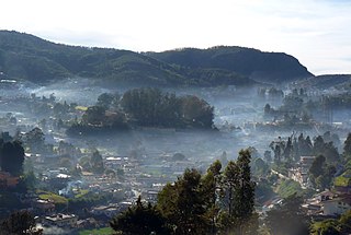
Ooty, officially known as Udhagamandalam, is a town and a municipality in the Nilgiris district of the South Indian state of Tamil Nadu. It is located 86 km (53 mi) north west of Coimbatore, 100 km north west of Tirupur, 128 km (80 mi) south of Mysore and is the headquarters of the Nilgiris district. It is a popular hill station located in the Nilgiri Hills. It is popularly called the "Queen of Hill Stations". It was the summer capital of the Madras Presidency.

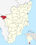
The Nilgiris district is one of the 38 districts in the southern Indian state of Tamil Nadu. Nilgiri is the name given to a range of mountains spread across the borders among the states of Tamil Nadu, Karnataka and Kerala. The Nilgiri Hills are part of a larger mountain chain known as the Western Ghats. Their highest point is the mountain of Doddabetta, height 2,637 m. The district is contained mainly within the Nilgiri Mountains range. The administrative headquarters is located at Ooty. The district is bounded by Malappuram district of Kerala to the west, Coimbatore and Palakkad to the south, Erode to the east, and Chamarajnagar district of Karnataka and Wayanad district of Kerala to the north. As it is located at the junction of three states, namely, Tamil Nadu, Kerala, and Karnataka, significant Malayali and Kannadiga populations reside in the district. Nilgiris district is known for natural mines of Gold, which is also seen in the other parts of Nilgiri Biosphere Reserve extended in the neighbouring states of Karnataka and Kerala too.

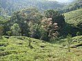
Kotagiri is a town and a taluk in The Nilgiris District in the Indian state of Tamil Nadu. The name ‘Kota-giri’ itself means ‘mountain of the Kotas’. The town has developed around numerous knolls and valleys. It is one of the largest hill station in the Nilgiri Mountains. Located at an average elevation of 1,950 m, Kotagiri is quietly tucked away in the Nilgiris and used to be one of the summer resort of Madras Presidency. The town was discovered in the year 1819 by John Sullivan when he came to a village called Dhimbatty to the North of Kotagiri. Situated at an elevation of about 6,400 feet, Kotagiri enjoys the third coldest climate next to Ooty and Kodaikanal in South India.

Kunnur, natively spelt as Coonor(pronunciation ), is a Taluk and a municipality of the Nilgiris district in the Indian State of Tamil Nadu. As of 2011, the town had a population of 45,494.
The Nilgiri Biosphere Reserve is a biosphere reserve in the Nilgiri Mountains of the Western Ghats in South India. It is the largest protected forest area in India, spreading across Tamil Nadu, Karnataka and Kerala. It includes the protected areas Mudumalai National Park, Mukurthi National Park, Sathyamangalam Wildlife Sanctuary in Tamil Nadu; Nagarhole National Park, Bandipur National Park, both in Karnataka; Silent Valley National Park, Aralam Wildlife Sanctuary, Wayanad Wildlife Sanctuary, and Karimpuzha Wildlife Sanctuary in Kerala.
Mettupalayam is a municipality town and taluk headquarters of Mettupalayam Taluk in the Coimbatore district of the Indian state of Tamil Nadu, a suburb of Coimbatore. It is the third largest town in the Coimbatore district after Coimbatore and Pollachi. It's located to the North of the Coimbatore city on the way to Ooty in the foothills of Nilgiri hills. As of 2011, the town had a population of 66,595. Mettupalayam railway station is the starting point of Nilgiri Mountain Railway and it operates the only rack railway in India connecting Ooty and Mettupalayam.,Native place of Vishanth ram, Harini sri
Wellington is a cantonment town in the Coonoor sub-Division of Nilgiris District of Tamil Nadu. One of its most famous residents was Field Marshal Sam Manekshaw, who died in the town on June 27, 2008. This town is adjacent to the town of Coonoor. Its Postal Index Number is 643231. Wellington is a Class II Cantonment. The administration and upkeep of the Cantonment is undertaken by the Cantonment Executive Officer of the DGDE, Ministry of Defence.
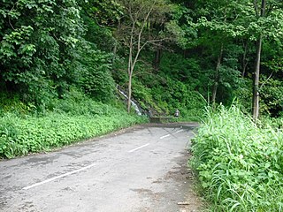
Many Ghat Roads can be found in the Nilgiris District of Tamil Nadu, Southern India. Nearly all of the district is located in the Nilgiri Hills, part of the Western Ghats mountains. This area borders the states of Karnataka and Kerala. The hills consequently can be reached by road from three states. Most of these Ghat Roads go through heavily forested mountains and contain a number of sharp hair-pin bends.
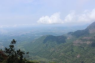
The Nilgiri Mountains form part of the Western Ghats in northwestern Tamil Nadu, Southern Karnataka, and eastern Kerala in India. They are located at the trijunction of three states and connect the Western Ghats with the Eastern Ghats. At least 24 of the Nilgiri Mountains' peaks are above 2,000 metres (6,600 ft), the highest peak being Doddabetta, at 2,637 metres (8,652 ft).
Vandicholai is a Panchayat village in Coonoor Taluk of The Nilgiris District, Tamil Nadu, India. The settlement takes its name from a nearby Shola. Though the adjective does not feature in the name, this is the Big Vandicholai; the Chinna Vandicholai is a settlement adjoining Wellington Cantonment. The village gets its name from the conjunction of two Badaga words [bandu+so:le; 'moth+woods'].

Yedapalli is a Panchayat village in Coonoor Taluk of The Nilgiris District, Tamil Nadu, India.

Sispara, സിസ്പാര, a proper noun, is a combination of the Badaga language words si:su + pore; meaning: magnetite bearing rock + gorge. It may refer to:
Montague Dundas Cockburn was a Scottish coffee planter, and Collector of Salem district between 1820 and 1829. He was the father of ornithologist and painter Margaret Cockburn.

Thanthanadu is a village in Kotagiri Taluk of The Nilgiris District, Tamil Nadu, India. The population is largely Badaga. It is located 2 km from Kotagiri. This village comprises both the Christians and the Hindus community. Tea is the major crop in this village. Thanthanadu is also known for its pear fruits.

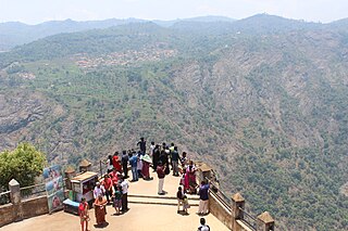
Kodanad View point is a tourist spot near Kotagiri town, Nilgiri District, Tamil Nadu state, South India.

Rangaswamy Peak and Pillar is a rocky column in Kotagiri, The Nilgiris, Tamil Nadu. It is located at a distance of 20 km from Kotagiri.
Achanakal is a Badaga village in the Nilgiris district in the Indian state of Tamil Nadu. The village is located adjacent to the Coonoor-Ooty highway in the Ketti valley. The name is believed to be derived from asinikol meaning bamboo sticks in Badaga language which formed the place before the village came into existence. Ketti valley is also considered the second steepest valley in the world. Achanakal is the largest village among the other 13 villages which are located in the valley. The village is just 3 Kilometres away from Ketti and the Lovedale railway stations.
Halatty Manthalatty is a village in the Indian state of Tamil Nadu, under the Nilgiris District. Halatty Manthalatty is also the name given to a range of mountains spread across the states of Tamil Nadu as well as Karnataka and Kerala. It is one of the small villages in Udhagamandalam Taluk in The Nilgiris District under Kadanad Panchayat. Around 100 families and Around 400 people are living in this village.
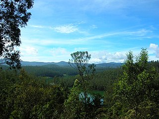
 Catherine Falls Shola
 Amazing Valley
 Catherine Falls