Related Research Articles

Ooty, officially known as Udhagamandalam ; abbreviated as Udhagai), is a town and a municipality in the Nilgiris district of the Indian state of Tamil Nadu. It is located 86 km (53 mi) north west of Coimbatore and is the headquarters of the Nilgiris district. Located in the Nilgiri Hills, it is known as the "Queen of Hill Stations" and is a popular tourist destination.
Nilgiri, which literally means "Blue Mountain", may refer to:

The Nilgiris district is one of the 38 districts in the southern Indian state of Tamil Nadu. Nilgiri is the name given to a range of mountains spread across the borders among the states of Tamil Nadu, Karnataka and Kerala. The Nilgiri Hills are part of a larger mountain chain known as the Western Ghats. Their highest point is the mountain of Doddabetta, height 2,637 m. The district is contained mainly within the Nilgiri Mountains range. The administrative headquarters is located at Ooty. The district is bounded by Coimbatore to the south, Erode to the east, and Chamarajnagar district of Karnataka and Wayanad district of Kerala to the north. As it is located at the junction of three states, namely, Tamil Nadu, Kerala, and Karnataka, significant Malayali and Kannadiga populations reside in the district. Nilgiris district is known for natural mines of Gold, which is also seen in the other parts of Nilgiri Biosphere Reserve extended in the neighbouring states of Karnataka and Kerala too.

Coonoor, is a Taluk and a municipality of the Nilgiris district in the Indian State of Tamil Nadu. As of 2011, the town had a population of 45,494.

Sathyamangalam is a town and municipality in Erode district in the Indian state of Tamil Nadu. It lies on the banks of the Bhavani river, a tributary of the Cauvery in the foothills of the Western Ghats and is the headquarters of Sathyamangalam taluk. It is about 65 km from Erode, 58 km from Tiruppur and 65 km from Coimbatore. As of 2011, the town had a population of 37,816.

Bhavani is an interstate Indian river which flows through Indian states of Kerala and Tamil Nadu, India. It originates from the Western Ghats and is one among the three rivers of Kerala which flows in eastward direction.

Coimbatore district is one of the 38 districts in the state of Tamil Nadu in India. Coimbatore is the administrative headquarters of the district. It is one of the most industrialized districts and a major textile, industrial, commercial, educational, information technology, healthcare and manufacturing hub of Tamil Nadu. The region is bounded by Tiruppur district in the east, Nilgiris district in the north, Erode district in the northeast, Palakkad district, Idukki district and small parts of Thrissur district and Ernakulam district of neighboring state of Kerala in the west and south respectively. As of 2011, Coimbatore district had a population of 3,458,045 with a sex ratio of 1,000 and literacy rate of 84%.

Devarshola is a panchayat town in The Nilgiris district in the state of Tamil Nadu, India.Devarshola comes under the administration of Gudalur revenue division and the taluk of Gudalur. It is one of the major tourist attractions in gudalur forest division and nearby to Mudumalai, Bandipur and Wayanad National parks. The state highway SH-98 Passing through the town which connects Gudalur and Sulthan Bathery.
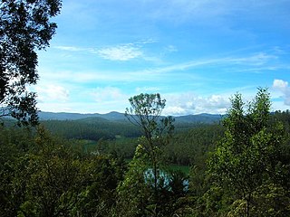
The Nilgiri Mountains form part of the Western Ghats in northwestern Tamil Nadu, Southern Karnataka, and eastern Kerala in India. They are located at the trijunction of three states and connect the Western Ghats with the Eastern Ghats. At least 24 of the Nilgiri Mountains' peaks are above 2,000 metres (6,600 ft), the highest peak being Doddabetta, at 2,637 metres (8,652 ft).

Hullickal or Pulikkal (புலிக்கல்) is a Revenue Village in Coonoor Taluk of the Nilgiris District, Tamil Nadu, India.
Nilgiris is a Lok Sabha constituency in Tamil Nadu. Its Tamil Nadu Parliamentary Constituency number is 19 of 39. Since 2009, this constituency is reserved for the candidates belonging to the Scheduled Castes.
Nilambur–Nanjangud line also called The golden I. T. corridor or Wayanad Railway, was a railway project to create a 5 ft 6in broad gauge rail connection from the town of Nanjangud (Karnataka) to Nilambur (Kerala) through Wayanad district of Kerala and Nilgiri district of Tamil Nadu.
Revenue blocks, revenue circles, firka, or patwar circles are the local revenue sub-divisions of the various districts of the states of India. The revenue blocks exist to simplify local administration, and each consists of a small number of revenue villages, governed by a revenue inspector. The revenue inspector is charged with a number of key administrative roles, most notably the identification and collection of tax revenue. Sometimes the land area in a revenue circle is identified as an inspector land revenue circle for administrative purposes. While revenue blocks may be as large as or larger than a tehsildar, revenue circles are generally smaller. In the state of Tamil Nadu alone, there are 1,349 revenue blocks.
The Coonoor block is a revenue block in the Nilgiris District of Tamil Nadu, India. It has a total of 6 panchayat villages.
The Gudalur block is a revenue block in the Nilgiris District of Tamil Nadu, India. It has a total of 5 panchayat villages.
The Udagamandalam block is a revenue block in the Nilgiris District of Tamil Nadu, India. It has a total of 13 panchayat villages.
Gudalur division is a revenue division in the Nilgiris district of Tamil Nadu, India. It is one of the three revenue divisions of Nilgiris District, and includes two talukas, Gudalur and Pandhalur. According to the 2011 census Gudalur Revenue division had an estimated population of 2,32,213.
Coonoor division is a revenue division in the Nilgiris District of Tamil Nadu, India. It is the only division of Nilagiri District to have two revenue blocks. According to 2011 census, Coonoor division has a population of 2,65,897 with total area of Coonoor and Kotagiri Taluk.

B. Pallipatti is a village in the Dharmapuri district of the Indian state of Tamil Nadu. The village code is 643526, and it is under the jurisdiction of B. Pallipatti Grama panchayath.
References
- "Map of revenue blocks of Nilgiris district". Government of Tamil Nadu. Archived from the original on 3 March 2016.
| District headquarters | 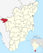 | |
|---|---|---|
| Country | ||
| State | ||
| Region | ||
| Divisions | ||
| Taluks | ||
| Revenue blocks | ||
| Municipalities | ||
| Rivers | ||
| History | ||
| Cities and towns | ||
| Villages |
| |
| Places of interest | ||
| | This article related to a location in The Nilgiris District, Tamil Nadu, India is a stub. You can help Wikipedia by expanding it. |