Chamarajanagar or Chamarajanagara is the southernmost district in the state of Karnataka, India. It was carved out of the original larger Mysore District in 1998. Chamarajanagar town is the headquarters of this district.

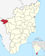
The Nilgiris district is one of the 38 districts in the southern Indian state of Tamil Nadu. Nilgiri is the name given to a range of mountains spread across the borders among the states of Tamil Nadu, Karnataka and Kerala. The Nilgiri Hills are part of a larger mountain chain known as the Western Ghats. Their highest point is the mountain of Doddabetta, height 2,637 m. The district is contained mainly within the Nilgiri Mountains range. The administrative headquarters is located at Ooty. The district is bounded by Coimbatore to the south, Erode to the east, and Chamarajnagar district of Karnataka and Wayanad district of Kerala to the north. As it is located at the junction of three states, namely, Tamil Nadu, Kerala, and Karnataka, significant Malayali and Kannadiga populations reside in the district. Nilgiris district is known for natural mines of Gold, which is also seen in the other parts of Nilgiri Biosphere Reserve extended in the neighbouring states of Karnataka and Kerala too.

Kotagiri is a Hill town and a taluk in The Nilgiris District in the Indian state of Tamil Nadu. The name ‘Kota-giri’ itself means ‘mountain of the Kotas’. The town has developed around numerous knolls and valleys. It is one of the largest hill station in the Nilgiri Mountains. Located at an average elevation of 1,950 m, Kotagiri is quietly tucked away in the Nilgiris and used to be one of the summer resort of Madras Presidency. The town was discovered in the year 1819 by John Sullivan when he came to a village called Dhimbatty to the North of Kotagiri. Situated at an elevation of about 6,400 feet, Kotagiri enjoys the third coldest climate next to Ooty and Kodaikanal in South India.

Kunnur, natively spelt as Coonor, is a Taluk and a municipality of the Nilgiris district in the Indian State of Tamil Nadu. As of 2011, the town had a population of 45,494.
Sathyamangalam is a town and municipality in Erode district in the Indian state of Tamil Nadu. 8th century Town. It lies on the banks of the River Bhavani, a tributary of the River Cauvery in the foothills of the Western Ghats. It is about 65 km from Erode, 58 km from Tiruppur and 70 km from Coimbatore. As of 2011, the town had a population of 37,816.

Ariyalur district is an administrative district, one of the 38 districts in the state of Tamil Nadu in India. The district headquarters is located at Ariyalur. The district encompasses an area of 1,949.31 km².

Gudalur is a municipality and taluk in Nilgiris district in the Indian state of Tamil Nadu.

Dharmapuri is one of the 38 districts in the state of Tamil-Nadu, India. It is the first district created in Tamil Nadu after the independence of India by splitting it from then-Salem district on 2 October 1965. Dharmapuri District is one of the major producers of mango in the state, fine quality granite is found in the district. It is also one of the main sericulture belts in the state. Around 30 percent of the district's area is under forest cover. Kaveri enters Tamil Nadu through this district. Dharmapuri district had the lowest literacy rate of 74.23% in Tamilnadu during the 2011 census.
Jagathala is a panchayat town in The Nilgiris district in the Indian state of Tamil Nadu.
Mallur is a village or town council (panchayat) in the Salem district, which is located in the Indian state of Tamil Nadu.
Mettupalayam is a municipality town and taluk headquarters of Mettupalayam Taluk in the Coimbatore district of the Indian state of Tamil Nadu, a suburb of Coimbatore. It is the third largest town in the Coimbatore district after Coimbatore and Pollachi. It's located to the North of the Coimbatore city on the way to Ooty in the foothills of Nilgiri hills. As of 2011, the town had a population of 66,595. Mettupalayam railway station is the starting point of Nilgiri Mountain Railway and it operates the only rack railway in India connecting Ooty and Mettupalayam.,Native place of Vishanth ram, Harini sri

Viluppuram, Villupuram or Vizhuppuram is one of the 38 districts that make up the state of Tamil Nadu, India. It was founded on 30 September 1993, prior to which it was part of the Cuddalore district. Vizhuppuram district lies in the way of the national highway connecting Tiruchirappalli and Chennai, and contains historical landmarks like the 500 year-old Gingee Fort.

Ketti also called Ketti Valley is a small town nestled in a large valley of the same name. It is located in The Nilgiris District of Tamil Nadu State, South India and is a Revenue Village of Coonoor Taluk. Upper Ketti is another village called Yellanahalli, which is located on the main Coonoor to Ooty road.
Pudumadam is a village located in the Ramanathapuram district of the Indian state of Tamil Nadu. Situated near the old National Highway 49, which connects Kochi and Dhanushkodi, Pudumadam serves as a vital gateway to the picturesque Pamban Island. The village is approximately 25 kilometers away from the city of Ramanathapuram and 37 kilometers away from the renowned pilgrimage site of Rameswaram. The nearest train station is Uchippuli, located just 4 kilometers away from Pudumadam.
Orathanad is a town in Thanjavur district of the Indian state of Tamil Nadu. It is recognised as a Town Panchayat. It is located at a distance of 33 km from Thanjavur and 35 km from Pattukkottai. The town is surrounded by vast agricultural lands.

Vazhikkadavu is a village in Nilambur taluk of Malappuram district, Kerala, India. As of 2011, it has total population of 47,322.
Mathur is a residential area located north of Chennai, a metropolitan city in Tamil Nadu, India. Mathur is administered by the Greater Chennai Corporation and belongs to Madhavaram taluk of Chennai district.

Masinagudi is a village in the Nilgiris District of the state of Tamil Nadu in India. It is located 30 km (19 mi) from the district headquarters at Ooty. It is in the buffer zone of the Mudumalai National Park. Masinagudi has several schools and other amenities and a number of resorts.
Kolathur is a neighborhood located in the northwestern region of Chennai, India.
Morai is a village in Ambattur Taluk, Tiruvallur District, Tamil Nadu, India. It is located in the western suburb of Chennai, about 23 kilometres away from the city center. As of 2011, it had a total population of 10,873.