Arch of Augustus (Fano)

Last updated
Arch of Augustus Arco (3).jpg
Arch of Augustus

The Arch of Augustus in Fano (in the Province of Pesaro and Urbino) is a city gate in the form of a triumphal arch with three vaults. It is the entrance to the city by the via Flaminia, which became the inside of the wall of the decumanus maximus. It is one of the symbols of the city.

Contents

History

The Arch of Augustus, intact, in the bass-relief of the facade of the neighbouring church of St Michael Bas-relief on the facade of the neighbouring church of Saint Michael showing how the Arch of Augustus was originally built, Fano, Italy (23132279729).jpg
The Arch of Augustus, intact, in the bass-relief of the facade of the neighbouring church of St Michael

In the Roman period it was the principal gate of Colonia Julia Fanestris, a colonia established in the town of Fanum Fortunae (temple of Fortuna) by the Roman architect Vitruvius at the command of the Emperor Augustus, in commemoration of the victory over the Carthaginian general Hasdrubal Barca in the Battle of Metauro during the Second Punic War.

It is presumed that at least two other (now lost) gates existed in Fanum Fortunae, one to the south and the other near the sea.

Constructed at the point at which the Via Flaminia met the decumanus maximus of the city, the monument is dated to AD 9 by means of an inscription located on the frieze, with large characters carved in the rock which were once gilded in bronze. The inscription reports:

IMP. CAESAR DIVI F. AVGVSTVS PONTIFEX MAXIMVS COS. XIII TRIBVNICIA POTESTATE XXXII IMP. XXVI PATER PATRIAE MVRVM DEDIT Imperator Caesar Augustus son of a god, Pontifex Maximus, Consul 13 times, recipient of tribunician power 32 times, acclaimed imperator 26 times, father of his country donated this wall.

The arch was later rededicated by the Emperor Constantine I with a new inscription on the attic which is now lost, but the earlier inscription was not erased. [1]

In 1463, during the siege of the city in order to expel its lord Sigismondo Pandolfo Malatesta, the artillery of Federico da Montefeltro, destroyed the attic of the monument. The fallen fragments were reused in the construction of the adjacent church and loggia of Saint Michael. The original appearance of the gate is recorded in the Renaissance bass relief carved on one side of the facade of the church.

Arch of Augustus at night Arco d'Augusto Fano.jpg
Arch of Augustus at night

Description

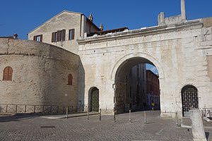
Faced with opus quadratum from blocks of Istrian stone, the monument consists of two minor lateral arches and a larger central arch; the keystone of the latter is decorated with an image of an animal, which is no longer recognisable but which most probably depicted an elephant. The main body, still well preserved, supported a large attic which is now lost, with a Corinthian pseudo-portico, in which there were seven arched windows separated by eight pseudo-columns. The whole monument has many stylistic similarities with the Augustan gates of Spello, Aosta and particularly with Authon in Provence.

See also

Related Research Articles

<span class="mw-page-title-main">Arch of Titus</span> Ancient Roman arch, a landmark of Rome, Italy

The Arch of Titus is a 1st-century AD honorific arch, located on the Via Sacra, Rome, just to the south-east of the Roman Forum. It was constructed in c. AD 81 by the Emperor Domitian shortly after the death of his older brother Titus to commemorate Titus's official deification or consecratio and the victory of Titus together with their father, Vespasian, over the Jewish rebellion in Judaea.

Via Flaminia Ancient Roman road

The Via Flaminia or Flaminian Way was an ancient Roman road leading from Rome over the Apennine Mountains to Ariminum (Rimini) on the coast of the Adriatic Sea, and due to the ruggedness of the mountains was the major option the Romans had for travel between Etruria, Latium, Campania, and the Po Valley. The section running through northern Rome is where Constantine the Great had his famous vision of the Chi Rho, leading to his conversion to Christianity and the Christianization of the Roman Empire.

<span class="mw-page-title-main">Fano</span> Comune in Marche, Italy

Fano[ˈfaːno] is a town and comune of the province of Pesaro and Urbino in the Marche region of Italy. It is a beach resort 12 kilometres southeast of Pesaro, located where the Via Flaminia reaches the Adriatic Sea. It is the third city in the region by population after Ancona and Pesaro.

<span class="mw-page-title-main">Porta del Popolo</span> Gate of the Aurelian walls, a landmark of Rome, Italy

The Porta del Popolo, or Porta Flaminia, is a city gate of the Aurelian Walls of Rome that marks the border between Piazza del Popolo and Piazzale Flaminio.

<span class="mw-page-title-main">Arch of Augustus, Rome</span>

The Arch of Augustus was the triumphal arch of Augustus, located in the Roman Forum. It spanned the Via Sacra, between the Temple of Castor and Pollux and the Temple of Caesar, near the Temple of Vesta, closing off the eastern end of the Forum. It can be regarded as the first permanent three-bayed arch ever built in Rome.

<span class="mw-page-title-main">Porta Tiburtina</span> Gate of the Aurelian walls, a landmark of Rome, Italy

Porta Tiburtina or Porta San Lorenzo is a gate in the Aurelian Walls of Rome, Italy, through which the Via Tiburtina exits the city.

<span class="mw-page-title-main">Tropaeum Alpium</span> Roman monument in La Turbie, Alpes-Maritimes, France

<span class="mw-page-title-main">Arch of Titus (Circus Maximus)</span>

The lesser-known Arch of Titus was a triple bay arch erected at the eastern end of the Circus Maximus by the Senate in A.D. 81, in honour of Titus and his capture of Jerusalem in the First Jewish–Roman War. Few traces remain. The inscription, quoted by an 8th-century Swiss monk known only as the "Einsiedeln Anonymous", makes it clear that this was Titus' triumphal arch. Sculptural fragments of a military frieze have been attributed to the arch.

<span class="mw-page-title-main">Arch of Claudius (British victory)</span>

The Arch of Claudius was a triumphal arch in Rome built in honour of the emperor Claudius's successful invasion of Britain in AD 43. It was dedicated in AD 51 but had already been anticipated in commemorative coins minted in AD 46–47 and 49, which depicted it summounted by an equestrian statue between two trophies. However, the real structure was a conversion of one of the arches of the Aqua Virgo aqueduct at the point where it crossed the Via Flaminia, the main road to the north, just north of the Saepta.

<span class="mw-page-title-main">Decumanus</span>

In Roman urban planning, a decumanus was an east–west-oriented road in a Roman city or castrum. The main decumanus of a particular city was the Decumanus Maximus, or most often simply "the Decumanus". In the rectangular street grid of the typical Roman city plan, the decumanus was crossed by the perpendicular cardo, a north–south street.

<span class="mw-page-title-main">Arco dei Gavi, Verona</span> Ancient Roman triumphal arch

<span class="mw-page-title-main">Arch of Caracalla (Thebeste)</span>

The Arch of Caracalla is a tetrapylon Roman triumphal arch in Thebeste, located in present-day Tébessa, Tébessa Province, Algeria. It was constructed during the early 3rd century.

<span class="mw-page-title-main">Arch of Augustus (Aosta)</span> Monument in the city of Aosta, northern Italy

<span class="mw-page-title-main">Arch of Augustus (Rimini)</span> Monument in Rimini, Italy

<span class="mw-page-title-main">Arch of Augustus (Susa)</span>

The Arch of Augustus is an important monument constructed in the city of Susa, Piedmont, in the province of Turin. It was originally built at the end of the 1st century BC to record the renewed alliance between Emperor Augustus and Marcus Julius Cottius, a Celto-Ligurian ruler who had been made king and Roman prefect of the Cottian Alps. The arch, together with other remains from the period, such as the Roman amphitheatre and a Roman aqueduct, underscore the importance that the city of Susa had during the Roman period.

<span class="mw-page-title-main">Arch of Trajan (Timgad)</span>

The Arch of Trajan is a Roman triumphal arch located in the city of Timgad, near Batna, Algeria. It was built between the later 2nd century and the early 3rd century.

<span class="mw-page-title-main">Temple of Isis and Serapis</span>

The Temple of Isis and Serapis was a double temple in Rome dedicated to the Egyptian deities Isis and Serapis on the Campus Martius, directly to the east of the Saepta Julia. The temple to Isis, the Iseum Campense, stood across a plaza from the Serapeum dedicated to Serapis. The remains of the Temple of Serapis now lie under the church of Santo Stefano del Cacco, and the Temple of Isis lay north of it, just east of Santa Maria sopra Minerva. Both temples were made up of a combination of Egyptian and Hellenistic architectural styles. Much of the artwork decorating the temples used motifs evoking Egypt, and they contained several genuinely Egyptian objects, such as couples of obelisks in red or pink granite from Syene.

<span class="mw-page-title-main">Temple of Jupiter Apenninus</span>

The Temple of Jupiter Apenninus or Temple of Jupiter Poeninus was an Umbrian-Roman temple that lay at the foot of Monte Catria, near the modern village of Scheggia, between today's Umbria and Marche regions, in Italy. The temple stood near the ancient Via Flaminia, 200 km from Rome, where the road crossed the Apennines. The structure, once one of the most important Umbrian shrines, has now completely disappeared.

The gens Turcia was an obscure plebeian family at ancient Rome. Few members of this gens appear in history, but a number are known from inscriptions, which indicate that the Turcii first came to prominence in the time of Augustus. After a period of relative unimportance, they repeatedly attained the highest offices of the Roman state from the third to the fifth century, holding several consulships.

References

  1. Silvio De Maria, Gli archi di Roma e dell'Italia romana, Roma 1988, pp.242-243.

Bibliography

43°50′35″N13°0′52.5″E / 43.84306°N 13.014583°E / 43.84306; 13.014583