
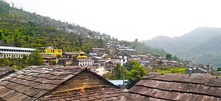
Pokhara is a metropolitan city located in central Nepal, which serves as the capital of Gandaki Province and is declared as the tourism capital of Nepal. It is the second most populous city of the nation after Kathmandu, with 599,504 inhabitants living in 120,594 households as of 2021. It is the country's largest metropolitan city in terms of area. The city also serves as the headquarters of Kaski District. Pokhara is located 200 kilometres west of the capital, Kathmandu. The city is on the shore of Phewa Lake, and sits at an average elevation of approximately 822 m above sea level. The Annapurna Range, with three out of the ten highest peaks in the world—Dhaulagiri, Annapurna I and Manaslu—is within 15–35 mi (24–56 km) aerial range from the valley.

Pokhara University was established in 1997 and is Nepal's fifth university. Its central office is located in Pokhara, Kaski District, Gandaki Province. Along with Purbanchal University, PU was formed as part of a government initiative to improve access to higher education. The Prime Minister of Nepal is the university chancellor and the Minister of Education is the pro-chancellor. The vice chancellor is the principal administrator of the university.

Kaski District, a part of Gandaki Province, is one of the seventy-seven districts of Nepal. The name is disambiguated from Kaskikot, the ancient Kaski Kingdom.

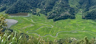
Pokhara Valley is the second-largest valley in the hilly region of Nepal. It lies in the western part of Nepal. The cities of Pokhara and Lekhnath are in the valley. As of 2023, Pokhara has a population of 599,504. It is located in Gandaki zone, 203 km (126 mi) west of Kathmandu Valley. The city of Pokhara is one of the major cities of Nepal and it, like Kathmandu Valley, is extremely vulnerable to earthquakes due to its clay soil and liquefaction potential.
Dhikurpokhari is a suburb and former Village Development Committee in Kaski District in the Gandaki Province of northern-central Nepal. At the 1991 Nepal census, it had a population of 7,392 persons in 1,427 individual households.
Kahun is a former village and Village Development Committee in Kaski District in the Gandaki Zone of northern-central Nepal. In 2015, it was annexed to Pokhara. At the time of the 2011 Nepal census it had a population of 14,716.
Saimarang is a town and Village Development Committee in Kaski District in the Gandaki Province of Western Nepal. At the time of the 2011 Nepal census it had a population of 1,171 persons living in 309 individual households. Saimarang owns a famous Temple Bhagawati Temple and hill known as Lamtari there is a famous Devi tample called Lamtari Mai which is in front of Pokhara Valley. The Annapurna Himalayan range can be seen at the back of the village, and Begnash, Rupa and Fewa lake in the front. Also there are several adventures such as caves, rocky hills. Local people in Warchowk and Togi are working hard to make the Saimarang VDC a good place for Adventurous Tourism. The people there are very helpful.
Bhalam was a Village Development Committee, north of Pokhara in the Valam Municipality of Kaski District, situated in the Gandaki Zone of the Western Development Region, located in northern-central Nepal. In 2015, the VDC was amalgamated with Pokhara. Bhalam is located around 950 m above sea level, 5 km from the city of Pokhara.
A Nag Dhunga is a sacred stone worshipped by the people of Nepal. These stones - often basalt rocks or erratic boulders - can be found in the centre of many major cities, as well as in remote villages. Sometimes they are enclosed within an ornamental wrought iron fence, with a gate that can only be unlocked by the local priest or elder. In some places, such as Kathmandu Valley or Pokhara Valley, the Nag Dhunga can be found on the premises of a shrine, or a small pagoda-like temple. These temples are often popular with tourists.
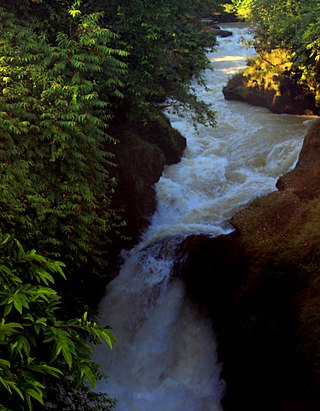
Devi's Fall is a waterfall located at Pokhara in Kaski District, Nepal.
Rupa Lake or Rupa Tal is a freshwater lake in Nepal located in the border of Pokhara Metropolitan and Rupa Rural Municipality of Kaski District. It is the third biggest lake in Pokhara valley of Nepal and at an altitude of 600 m (1,969 ft) covering area about 1.35 km2 (0.5 sq mi) with an average water depth 3 m (9.8 ft) and maximum depth 6 m (20 ft). The lake is elongated north to south and is fed by perennial streams. Its watershed area is 30 km2, where The main inflow of water is from Talbesi stream, whereas Dhovan khola is the feeder stream with its outlet Tal khola at Sistani ghat. It supports a number of floral and faunal species. A total of 36 species of waterbirds have been recorded in the lake which represents about 19 percent of the total 193 wetland-dependent birds found in Nepal.

Mahendra Cave is a cave located in Pokhara-16,batulechaur, Kaski district, close to the Kali khola, is a large limestone cave. It is a rare example of a cave system in Nepal containing stalagmites and stalactites. This show cave attracts thousands of tourists every year. A statue of Hindu lord Shiva can be found inside the cave.

Gandaki Province ), is one of the seven federal provinces established by the current constitution of Nepal which was promulgated on 20 September 2015. Pokhara is the province's capital city. It borders the Tibet Autonomous Region in Southwest China to the north, Bagmati Province to the east, Karnali Province to the west, and Lumbini Province and Bihar of India to the south. The total area of the province is 21,504 km2 - constituting 14.57% of Nepal's total area. According to the latest census, the population of the province was 2,479,745. The newly elected Provincial Assembly adopted Gandaki Province as the permanent name by replacing its initial name Province No. 4 on 27 April 2023. Surendra Raj Pandey is the present chief minister of Gandaki Province.

Paundur (पाउँदुर) is a central village in Kaski district of Gandaki Province of Nepal. It lies about 28 km west of the Pokhara valley and 38 km east of Kushma, Parbat. It is a part of ward no. 3 of Annapurna Gaupalika of Gandaki Province of Nepal, and was the ward no.5 and 8 of the former Dhikurpokhari VDC.It lies west of Nagdanda; nearest sub urban area. There are more than 100 houses in this village.
Kundahar(Nepali: कुँडहर)is the residential area of Pokhara, Nepal. Kundahar covers ward no 12,13,14 of the Pokhara Metropolitan City.
Annapurna Rural Municipality, Kaski is a Gaunpalika in Kaski District in Gandaki Province of Nepal named after the Annapurna Mountain. On 12 March 2017, the Government of Nepal implemented a new local administrative structure. With the implementation of the new local administrative structure, VDSs have been replaced with municipal and village councils. Annapurna Gaupalika is one of these 753 local units.

Kaski 1 is one of three parliamentary constituencies of Kaski District in Nepal. This constituency came into existence on the Constituency Delimitation Commission (CDC) report submitted on 31 August 2017.

Kaski 3 is one of three parliamentary constituencies of Kaski District in Nepal. This constituency came into existence on the Constituency Delimitation Commission (CDC) report submitted on 31 August 2017.
In between November 2013 to 2017, more than 200 sinkholes were formed in the Armala area of Pokhara. The sinkholes were formed mostly in the paddy fields in the alluvial fan deposit. The sinkholes terrorised and displaced hundreds of local residents.


