
Kaski District (Nepali: कास्की जिल्ला[kaski], a part of Gandaki Province, is one of the seventy-seven districts of Nepal. The name is disambiguated from Kaskikot, the ancient Kaski Kingdom.

Solududhkunda (earlier:Dudhkunda) is the only municipality of Solukhumbu District. Located in Province No. 1 of Nepal. The town of Salleri, which is located within the municipality is the headquarter of Solukhumbu District It was formed in 2014 by merging four VDCs: Salleri, Garma, Loding Tamakhani and Beni and was divided into 9 wards. Total area of the municipality had 254.3 square kilometres (98.2 sq mi) and population of municipality had 20,399 individuals living in 5,368 households.

Patarasi is a rural municipality located in Jumla District of Karnali Province of Nepal.
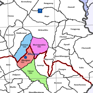
Bokhim is a former VDC and now a neighborhood of Bhojpur Municipality in Bhojpur District in the Province No. 1 of eastern Nepal. At the time of the 1991 Nepal census it had a population of 3438 persons living in 618 individual households.

Chulachuli is a rural municipality (gaunpalika) out of six rural municipality located in Ilam District of Province No. 1 of Nepal. There are a total of 10 municipalities in Ilam in which 4 are urban and 6 are rural.
Siddhithumka is a village and Village Development Committee in Ilam District in the Province No. 1 of eastern Nepal. At the time of the 1991 Nepal census it had a population of 2,937 persons living in 545 individual households.

Saimarang is a town and Village Development Committee in Kaski District in the Gandaki Province of Western Nepal. At the time of the 2011 Nepal census it had a population of 1,171 persons living in 309 individual households. Saimarang owns a famous Temple Bhagawati Temple and hill known as Lamtari there is a famous Devi tample called Lamtari Mai which is in front of Pokhara Valley. We can see the Annapurna Himalayan range at the back and Begnash, Rupa and Fewa lake in the front. Also there are several adventures such as caves, rocky hills. Local people in Warchowk and Togi are working hard to make the Saimarang VDC a good place for Adventurous Tourism. The people there are very helpful.

Sarangkot is Ward 18 of Pokhara, Kaski District, Nepal, after it was merged into the city in 2015. It is a popular tourist destination for those who arrive in Pokhara. At the 1991 Nepal census it had a total population of 5,060 with 1,010 individual households.
Bhalam was a Village Development Committee, north of Pokhara in the Valam Municipality of Kaski District, situated in the Gandaki Zone of the Western Development Region, located in northern-central Nepal. In 2015, the VDC was amalgamated with Pokhara.
Kaskikot, commonly known as Kaski, is a Ward no. 24 of the Pokhara metropolitan city. It was earlier a part of the village development committee in Kaski District, a region in northern-central Nepal.

Babare is a village in Kalinchowk Rural Municipality in Dolakha District in the Bagmati Province of north-eastern Nepal. At the time of the 1991 Nepal census it had a population of 3,392 people living in 739 individual households.

Melung is a Rural municipality located within the Dolakha District of the Bagmati Province of Nepal. The municipality spans 86.54 square kilometres (33.41 sq mi) of area, with a total population of 20,210 according to a 2011 Nepal census.
Khandadevi is a populated place and a ward of Khandadevi Rural Municipality. It was a village development committee before 10 March 2017. At the time of the 1991 Nepal census it had a population of 3,751 people living in 650 individual households.
Serachaur सेराचौर is a village which is located in Kaski District, Gandaki Province, Nepal. The word Sera refers to a plain land which is used to farm and supply food to a palace and Chaur means a grassy land. First settlers of this village were Adhikari Family. It is a part of the Annapurna Gaunpalika ward number- 2, Kaski, Nepal. Pastly the village was part of Dhikurpokhari V.D.C but later the Ministry of Federal Affairs and Local Development (Nepal) dissolved the existing village development committees and announced the establishment of this new local body. Visitors can take the Baglung Highway, Kaskikot road and other existing trails to reach here. Concrete pavement is recent installation to the road.
Paundur (पाउँदुर) is a central village in Kaski district of Gandaki Province of Nepal. It lies about 28 km west of the Pokhara valley and 38 km east of Kushma, Parbat. It is a part of ward no. 3 of Annapurna Gaupalika of Gandaki Province of Nepal, and was the ward no.5 and 8 of the former Dhikurpokhari VDC.It lies west of Nagdanda; nearest sub urban area. There are more than 100 houses in this village.

Sunkoshi Rural Municipality is a rural municipality in Sindhuli district of Bagmati Province in Nepal. The Rural municipality is divided into 7 wards. According to 2011 Nepal census, the total population of the municipality is 21,473 with 4,557 households. The total area of the municipality is 158.68 square kilometres (61.27 sq mi) The headquarter of the municipality is at Jhangajholi Ratmata.
Tolidewal was a VDC in Bajura District. Now this VDC is the part of Triveni Municipality of Sudurpashchim Province. At the time of 1991 Nepal census it had a population of 2,991 and had 599 houses in the village. Triveni Municipality office is also located here.

Kalinchowk is a Rural municipality located within the Dolakha District of the Bagmati Province of Nepal. The municipality spans 132.49 square kilometres (51.15 sq mi) of area, with a total population of 22,954 according to a 2011 Nepal census.


