
Kaski District, a part of Gandaki Province, is one of the seventy-seven districts of Nepal. The name is disambiguated from Kaskikot, the ancient Kaski Kingdom.

Syangja District, a part of Gandaki Province, is one of the seventy-seven districts of Nepal. The district, with Syangja bazaar as its district headquarters, covers an area of 1,164 km2 (449 sq mi) and had a population of 289,148 It lies in the hilly region at an altitude ranging from about 300 meters along the banks of Kaligandaki river up to a couple of thousands meters above the sea level. It lies at about latitude 28°4'60 North and longitude 83°52'0 East.
Bongadobhan is a village development committee in Baglung District in the Dhaulagiri Zone of central Nepal. At the time of the 1991 Nepal census it had a population of 4,537 and had 904 houses in the town.
Hatiya is a Village Development Committee in Baglung District in the Dhaulagiri Zone of central Nepal. At the time of the 1991 Nepal census it had a population of 6,015 and had 1131 houses in the town.
Narayansthan is a village development committee in Baglung District in the Dhaulagiri Zone of central Nepal.It is located above the bank of Kali gandaki River. Now, it has become one of the major important place in baglung. They have planned to construct the domestic Airport. At the time of the 2011 Nepal census it had a population of 2,876 and had 781 houses in the town. The major castes living in the VDC are Brahman, Chhetry and Newar. There are 2 high schools - Janatadhan Higher School and Ganesh Secondary School and one campus. Krishna Gandaki Campus is at the premises of Janatadhan HSS. Ganesh Secondary School, one of the best schools in the region is known for its quality education movement. Established in 1957 [2014 BS] by Soldier Board (India), Ganesh Secondary School is one of the oldest schools. In 1964 [2021 BS], the Indian Soldier Board stopped its grant. Since there was no school support mechanism developed from the Government of Nepal, the school passed through many ups and downs. After Modern Education Act came in effect in 1971 BS [2028 BS], the school merged with Janatadhan Higher Secondary School. In 1980 [2037 BS], the school was reopened.
Neta is a village and municipality in Gulmi District in the Lumbini Zone of central Nepal. At the time of the 1991 Nepal census it had a population of 2375 persons residing in 451 individual households.
Paudi Amarahi is a town and municipality in Gulmi District in the Lumbini Zone of central Nepal. At the time of the 1991 Nepal census it had a population of 4136 persons living in 742 individual households.
Bharat Pokhari is a town in Kaski District in the Gandaki Province of northern-central Nepal. At the 1991 Nepal census, it had a population of 8,889 persons living in 1782 individual households. Bharat Pokhari was a Village Development Committee, and it was merged with Lekhnath Municipality.
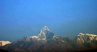
Deurali is a Village Development Committee in Kaski District of the Gandaki province of north-central Nepal. At the time of the 1991 Nepal census, it had a population of 2,882. The base camp of Mount Machapuchare is situated at a 6-hour uphill trek from the village.

Dhital, formerly a village development committee in Kaski District, Gandaki Zone, is now located in Machhapuchhre rural municipality, ward number 6 in Kaski district, Gandaki Province, Nepal. At the 1991 Nepal census, it had a population of 4,121 persons in 862 individual households. Dhital is near Annapurna Himalaya and on its trekking route.
Kristinachnechaur is a former Village Development Committee south of Pokhara in Kaski District in the Gandaki Zone of northern-central Nepal. In 2015, it was annexed to Pokhara. At the 1991 Nepal census, it had a population of 5,757 persons in 1,145 individual households.
Machhapuchchhre is a Gaunpalika and former village development committee in Kaski District in the Gandaki Province of northern-central Nepal. At the time of the 1991 Nepal census it had a population of 1,881 persons living in 378 individual households.
Mala is a village and Village Development Committee in Kaski District in the Gandaki Zone of northern-central Nepal. At the time of the 1991 Nepal census it had a population of 2,704 persons living in 510 individual households.
Mijuredanda is a town and Village Development Committee in Kaski District in Gandaki Province of northern-central Nepal. At the time of the 1991 Nepal census it had a population of 4,394 persons living in 907 individual households.
Parche is a town and Village Development Committee (VDC) in Kaski District in the Gandaki Zone of northern-central Nepal. At the 1991 Nepal census, it had a population of 3,182 persons in 669 individual households.

Rupakot is a town and Village Development Committee in Kaski District in the Gandaki Zone of northern-central Nepal. At the time of the 1991 Nepal census it had a population of 3,785 persons residing in 789 individual households.
Saimarang is a town and Village Development Committee in Kaski District in the Gandaki Province of Western Nepal. At the time of the 2011 Nepal census it had a population of 1,171 persons living in 309 individual households. Saimarang owns a famous Temple Bhagawati Temple and hill known as Lamtari there is a famous Devi tample called Lamtari Mai which is in front of Pokhara Valley. The Annapurna Himalayan range can be seen at the back of the village, and Begnash, Rupa and Fewa lake in the front. Also there are several adventures such as caves, rocky hills. Local people in Warchowk and Togi are working hard to make the Saimarang VDC a good place for Adventurous Tourism. The people there are very helpful.
Thumki is a town and Village Development Committee in Kaski District in the Gandaki Zone of northern-central Nepal. At the time of the 1991 Nepal census it had a population of 3,946 persons living in 778 individual households.
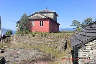
Kaskikot, commonly known as Kaski, is a Ward no. 24 of the Pokhara metropolitan city. It was earlier a part of the village development committee in Kaski District, a region in northern-central Nepal.
Nanda Nagar is a village development committee in Kapilvastu District in the Lumbini Zone of southern Nepal. At the time of the 1991 Nepal census it had a population of 4740 people living in 808 individual households.
