Sarangkot

Last updated
Sarangkot
सराङकोट
Subdivision of Pokhara
Sunset flying above Himalayas.jpg
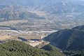
View from Sarangkot to Annapurna Conservation Area
Nepal Gandaki adm location map.svg
Red pog.svg
Sarangkot
Location in Nepal
Nepal adm location map.svg
Red pog.svg
Sarangkot
Sarangkot (Nepal)
Coordinates: 28°14′30″N83°58′0″E / 28.24167°N 83.96667°E / 28.24167; 83.96667
CountryFlag of Nepal.svg    Nepal
Zone Gandaki Zone
District Kaski District
Area Pokhara
Population
 (1991)
  Total5,060
Time zone UTC+5:45 (NST)
Area code 061

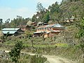
Sarangkot is Ward 18 of Pokhara, Kaski District, Nepal, after it was merged into the city in 2015. It is a popular tourist destination for those who arrive in Pokhara. At the 1991 Nepal census it had a total population of 5,060 with 1,010 individual households. [1]

Contents

The Ward is located on Sarangkot, a hill on the western side of Pokhara with an altitude of 1600m. Sarangkot is known for its panoramic Himalayan views of Dhaulagiri, Annapurna and Manaslu. It also provides an expansive view of the city of Pokhara, from the extreme north to the south including Phewa Lake. Tourists drive up the hill to watch the sunrise from the view tower at the top. In recent years, Sarangkot has been called one of the best paragliding locations in the world. [2] [3] The hike up from the Pokhara Baglung highway at Miruwa to Sarangkot takes 90 minutes to 1.5hours. [4]

Sarangkot has one community FM radio station called Radio Sarangkot. It broadcasts at 104.6 MHz.

Related Research Articles

<span class="mw-page-title-main">Pokhara</span> Metropolitan city in Gandaki Province, Nepal

Pokhara is a metropolitan city in central Nepal, which serves as the capital of Gandaki Province. It is the second most populous city of Nepal after Kathmandu, with 599,504 inhabitants living in 120,594 households in 2021. It is the country's largest metropolitan city in terms of area. The city also serves as the headquarters of Kaski District. Pokhara is located 200 kilometres west of the capital, Kathmandu. The city is on the shore of Phewa Lake, and sits at an elevation of approximately 822m. The Annapurna Range, with three out of the ten highest peaks in the world—Dhaulagiri, Annapurna I and Manaslu—is within 15–35 mi (24–56 km) of the valley. The current mayor of Pokhara is Dhana Raj Acharya from CPN.

<span class="mw-page-title-main">Kaski District</span> District in Gandaki Province, Nepal

Kaski District, a part of Gandaki Province, is one of the seventy-seven districts of Nepal. The name is disambiguated from Kaskikot, the ancient Kaski Kingdom.

Lekhnath was a municipality in Kaski District in the Gandaki Province of northern-central Nepal, about 180 km west of Kathmandu. It has now been merged into Pokhara sub-metropolitan city to form Pokhara metropolis. Pokhara Valley was politically divided between Pokhara city and Lekhnath which occupied the eastern half of the valley. There were 18 wards in total in Lekhnath municipality before the merger, with a VDC Bharat Pokhari that had been added at a later stage.

<span class="mw-page-title-main">Prithvi Highway</span>

The Prithvi Highway is a 174-kilometre-long (108 mi) highway connecting Naubise of Tribhuvan Highway, 26 km from Kathmandu, the capital of Nepal, and Prithivi Chowk, Pokhara, a tourist city in the western part of Nepal.

<span class="mw-page-title-main">Jomsom</span> Town in Mustang, Nepal

Jomsom, also known as Dzongsam is the centre of Gharapjhong rural municipality in Mustang district and a former independent village development committee situated at an altitude of about 2,700 metres (8,900 ft) in Gandaki Province of western Nepal. The soaring peaks of Dhaulagiri and Nilgiri form a backdrop to the town straddling the Kali Gandaki River, which flows right through the centre of Jomsom. Along the banks of the Kali Gandaki, black fossilised stones called shaligram, considered as an iconic symbol and reminder of the god Vishnu in the Hindu culture, can be found. Such stones are believed to be found only in the Kali Gandaki, and are holy to the Hindus.

<span class="mw-page-title-main">Phewa Lake</span> Lake in Nepal

Phewa Lake, Phewa Tal or Fewa Lake is a freshwater lake in Nepal formerly called Baidam Tal located in the south of the Pokhara Valley that includes Pokhara city and parts of Sarangkot and Kaskikot. It is the second largest lake in Nepal and the largest in Gandaki Province after the Rara lake in comparison to Nepal's water bodies. It is the most popular and most visited lake in Nepal. Phewa lake is located at an altitude of 742 m (2,434 ft) and covers an area of about 5.7 km2 (2.2 sq mi). It has an average depth of about 8.6 m (28 ft) and a maximum depth of 24 m (79 ft). The maximum water capacity of the lake is approximately 43,000,000 cubic metres (35,000 acre⋅ft). The Annapurna range on the north is only about 28 km away from the lake. The lake is also famous for the reflection of mount Machhapuchhre and other mountain peaks of the Annapurna and Dhaulagiri ranges on its surface. The Tal Barahi Temple is situated on an island in the lake. It is located 4 km from the city's centre Chipledhunga.

<span class="mw-page-title-main">Pokhara Valley</span> Valley in the hilly region of western Nepal

Pokhara Valley is the second-largest valley in the hilly region of Nepal. It lies in the western part of Nepal. The cities of Pokhara and Lekhnath are in the valley. As of 2023, Pokhara has a population of 599,504. It is located in Gandaki zone, 203 kilometres (126 mi) west of Kathmandu Valley. The city of Pokhara is one of the major cities of Nepal and it, like Kathmandu Valley, is extremely vulnerable to earthquakes due to its clay soil and liquefaction potential.

<span class="mw-page-title-main">Dhampus</span> Village Development Committee in Gandaki Zone, Nepal

Dhampus is a village and Village Development Committee in Kaski District in the Gandaki Zone of northern-central Nepal. At the time of the 1991 Nepal census it had a population of 2,753 persons living in 547 individual households. It is gradually turning into a tourist destination. It has the Australian Base Camp with views of the peaks Annapurna, Dhaulagiri And Machhapuchhre.

Dhikurpokhari is a suburb and former Village Development Committee in Kaski District in the Gandaki Province of northern-central Nepal. At the time of the 1991 Nepal census it had a population of 7,392 persons living in 1,427 individual households.

<span class="mw-page-title-main">Ghandruk</span> Village Development Committee in Gandaki Province, Nepal

Ghandruk is a Village Development Committee in the Kaski District of the Gandaki Province of Nepal. Situated at a distance of 32 km north-west to Pokhara, the village is readily accessible by public buses and private taxis from the provincial headquarter. At the time of the 1991 Nepal census, it had a population of 4,748 residing in 1,013 individual households.

Hemja is a former Village Development Committee in the north of Pokhara in Kaski District in the Gandaki Province of northern-central Nepal. In 2014, Hemja was annexed to Pokhara City as ward number 27. Hemja is now under Pokhara Municipality ward #25. At the time of the 2011 Nepal census, it had a population of 12,262 living in 3,019 households.

Saimarang is a town and Village Development Committee in Kaski District in the Gandaki Province of Western Nepal. At the time of the 2011 Nepal census it had a population of 1,171 persons living in 309 individual households. Saimarang owns a famous Temple Bhagawati Temple and hill known as Lamtari there is a famous Devi tample called Lamtari Mai which is in front of Pokhara Valley. The Annapurna Himalayan range can be seen at the back of the village, and Begnash, Rupa and Fewa lake in the front. Also there are several adventures such as caves, rocky hills. Local people in Warchowk and Togi are working hard to make the Saimarang VDC a good place for Adventurous Tourism. The people there are very helpful.

<span class="mw-page-title-main">Kaskikot</span> Subdivision of Pokhara Metropolitan City in Gandaki Province, Nepal

Kaskikot, commonly known as Kaski, is a Ward no. 24 of the Pokhara metropolitan city. It was earlier a part of the village development committee in Kaski District, a region in northern-central Nepal.

<span class="mw-page-title-main">Naudanda</span> City in Gandaki Zone, Nepal

Naudanda is a village in Kaski District in the Gandaki Zone of northern-central Nepal. There are views of the Annapurna Range from this area of Pokhara, Nepal. It is on the way to Sarangkot, the world's 5th paragliding spot 6 km away from Pokhara.

<span class="mw-page-title-main">Annapurna Circuit</span> Mountain trail in central Nepal

The Annapurna Circuit is a trek within the mountain ranges of central Nepal. The total length of the route varies between 160–230 km, depending on where motor transportation is used and where the trek is ended. This trek crosses two different river valleys and encircles the Annapurna Massif. The path reaches its highest point at Thorung La pass, reaching the edge of the Tibetan plateau. Most trekkers hike the route anticlockwise, as this way the daily altitude gain is slower, and crossing the high Thorong La pass is easier and safer.

<span class="mw-page-title-main">Begnas Lake</span> Lake in Kaski district of Nepal

Begnas Lake is a freshwater lake in Pokhara Metropolis of Kaski district of Nepal located in the south-east of the Pokhara Valley. The lake is the third largest lake of Nepal and second largest, after Phewa Lake, among the eight lakes in Pokhara Valley. Water level in the lake fluctuates seasonally due to rain, and utilization for irrigation. The water level is regulated through a dam constructed in 1988 on the western outlet stream, Khudi Khola.

<span class="mw-page-title-main">Shanti Stupa, Pokhara</span> Peace pagoda in Pokhara, Nepal

Pokhara Shanti Stupa is a Buddhist monument on Anadu Hill of the former Pumdi Bhumdi Village Development Committee, in the district of Kaski, Nepal.

<span class="mw-page-title-main">Serachaur</span>

Serachaur सेराचौर is a village which is located in Kaski District, Gandaki Province, Nepal. The word Sera refers to a plain land which is used to farm and supply food to a palace and Chaur means a grassy land. First settlers of this village were Adhikari Family. It is a part of the Annapurna Gaunpalika ward number- 2, Kaski, Nepal. Pastly the village was part of Dhikurpokhari V.D.C but later the Ministry of Federal Affairs and Local Development (Nepal) dissolved the existing village development committees and announced the establishment of this new local body. Visitors can take the Baglung Highway, Kaskikot road and other existing trails to reach here. Concrete pavement is recent installation to the road.

<span class="mw-page-title-main">Paudhur</span> Village in Nepal in Gandaki Province

Paundur (पाउँदुर) is a central village in Kaski district of Gandaki Province of Nepal. It lies about 28 km west of the Pokhara valley and 38 km east of Kushma, Parbat. It is a part of ward no. 3 of Annapurna Gaupalika of Gandaki Province of Nepal, and was the ward no.5 and 8 of the former Dhikurpokhari VDC.It lies west of Nagdanda; nearest sub urban area. There are more than 100 houses in this village.

<span class="mw-page-title-main">Annapurna Rural Municipality, Kaski</span> Gaunpalika in Gandaki, Nepal

Annapurna Rural Municipality, Kaski is a Gaunpalika in Kaski District in Gandaki Province of Nepal named after the Annapurna Mountain. On 12 March 2017, the Government of Nepal implemented a new local administrative structure. With the implementation of the new local administrative structure, VDSs have been replaced with Municipal and Village Councils. Annapurna Gaupalika is one of these 753 local units.

References

  1. "Nepal Census 2001". Nepal's Village Development Committees. Digital Himalaya . Retrieved September 30, 2008.
  2. House, Media (2004-12-01). Columbus World Travel Guide, 2004-2005. Highbury Columbus Travel Pub. p. 514. ISBN   978-1-902221-84-7.
  3. Nepal. Lonely Planet Publications. 2009. p. 87.
  4. Wheeler, Tony; Everist, Richard (1990). Nepal, a travel survival kit. Lonely Planet Publications. p. 292. ISBN   978-0-86442-024-4.