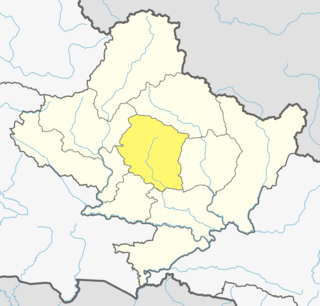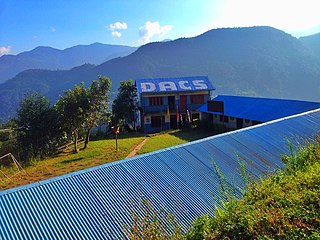
Pokhara is a metropolitan city in Nepal, which serves as the capital of Gandaki Province. It is the country's largest metropolitan city in terms of area and second-largest in terms of population. The city also serves as the headquarters of Kaski District. Pokhara is located 200 kilometres west of the capital, Kathmandu. The city is on the shore of Phewa Lake, and sits at an elevation of approximately 822m. The Annapurna Range, with three out of the ten highest peaks in the world—Dhaulagiri, Annapurna I and Manaslu—is within 15–35 mi (24–56 km) of the valley.

Kaski District (Nepali: कास्की जिल्ला[kaski], a part of Gandaki Province, is one of the seventy-seven districts of Nepal. The name is disambiguated from Kaskikot, the ancient Kaski Kingdom.

Arba Vijaya is a very old residential area in Pokhara sub-metropolitan city in Kaski District in the Gandaki Zone of northern-central Nepal. At the time of the 1991 Nepal census it had a population of 3,446 persons living in 714 individual households. village located at surrounding mountain Himalaya it is a destination in Anna Purna Himalaya Region. One can reach there from Pokhara within 2 hours by walking for 30 min by driving village has many natural sources, most of people living at villages are Brahmin, chettri, Gurung, Bishwakarma, Pariyar caste.

Dhikurpokhari is a suburb and former Village Development Committee in Kaski District in the Gandaki Province of northern-central Nepal. At the time of the 1991 Nepal census it had a population of 7,392 persons living in 1,427 individual households.

Ghandruk is a Village Development Committee in the Kaski District of the Gandaki Province of Nepal. Situated at a distance of 32 km north-west to Pokhara, the village is readily accessible by public buses and private taxis from the provincial headquarter. At the time of the 1991 Nepal census, it had a population of 4,748 residing in 1,013 individual households.

Hemja is a former Village Development Committee in the north of Pokhara in Kaski District in the Gandaki Province of northern-central Nepal. In 2014, Hemja was annexed to Pokhara City as ward number 27. Hemja is now under Pokhara Municipality ward #25. At the time of the 2011 Nepal census, it had a population of 12,262 living in 3,019 households.

Kahun is a former village and Village Development Committee in Kaski District in the Gandaki Zone of northern-central Nepal. In 2015, it was annexed to Pokhara. At the time of the 1991 Nepal census it had a population of 2,211.
Kristinachnechaur is a former Village Development Committee south of Pokhara in Kaski District in the Gandaki Zone of northern-central Nepal. In 2015, it was annexed to Pokhara. At the time of the 1991 Nepal census it had a population of 5,757 persons living in 1,145 individual households.

Lahachok is a village in Machhapuchchhre Gaunpalika, in the Kaski District, in the Gandaki Zone of northern-central Nepal. According to the 2011 National Population and Housing Census, it had a population of 3,129 in 829 individual households.

Pumdibhumdi is a former Village Development Committee south of Pokhara in Kaski District in the Gandaki Zone of northern-central Nepal. In 2015 it was annexed to Pokhara. At the time of the 1991 Nepal census it had a population of 6,512 persons living in 1326 individual households.

Puranchaur is a former Village Development Committee in Kaski District in the Gandaki Province of northern-central Nepal. It is now annexed to Pokhara metropolitan city, and is ward no. 19 of it. At the time of the 2011 Nepal census it had a population of 3,597 persons living in 865 individual households.

Salyan is a town and Village Development Committee in Kaski District in the Gandaki Zone of northern-central Nepal. At the time of the 1991 Nepal census it had a population of 3,254 persons living in 665 individual households.

Sarangkot is Ward 18 of Pokhara, Kaski District, Nepal, after it was merged into the city in 2015. It is a popular tourist destination for those who arrive in Pokhara. At the 1991 Nepal census it had a total population of 5,060 with 1,010 individual households.
Shisuwa is a town and once a Village Development Committee in Kaski District in the Gandaki Zone of northern-central Nepal. At the time of the 1991 Nepal census it had a population of 12,127.

Bhalam was a Village Development Committee, north of Pokhara in the Valam Municipality of Kaski District, situated in the Gandaki Zone of the Western Development Region, located in northern-central Nepal. In 2015, the VDC was amalgamated with Pokhara.

Kaskikot, commonly known as Kaski, is a Ward no. 24 of the Pokhara metropolitan city. It was earlier a part of the village development committee in Kaski District, a region in northern-central Nepal.

Begnas Lake is a freshwater lake in Pokhara Lekhnath Metropolis of Kaski district of Nepal located in the south-east of the Pokhara Valley. The lake is the third largest lake of Nepal and second largest, after Phewa Lake, among the eight lakes in Pokhara Valley. Water level in the lake fluctuates seasonally due to rain, and utilization for irrigation. The water level is regulated through a dam constructed in 1988 on the western outlet stream, Khudi Khola.

Serachaur सेराचौर is a village which is located in Kaski District, Gandaki Province, Nepal. The word Sera refers to a plain land which is used to farm and supply food to a palace and Chaur means a grassy land. First settlers of this village were Adhikari Family. It is a part of the Annapurna Gaunpalika ward number- 2, Kaski, Nepal. Pastly the village was part of Dhikurpokhari V.D.C but later the Ministry of Federal Affairs and Local Development (Nepal) dissolved the existing village development committees and announced the establishment of this new local body. Visitors can take the Baglung Highway, Kaskikot road and other existing trails to reach here. Concrete pavement is recent installation to the road.

Bhadrakali Temple is a temple on the East of Pokhara in Kundahar, atop a small hill. It is dedicated to the Goddess Kali. Founded in the year 1817, the temple shrines the Hindu goddess of power and strength. Bhadrakali or Durga covers an area of 135 ropanies. There are two ways to reach atop: the eastern way has 292 steps to reach the temple while traversing from the southern part is only 265 steps. In the year 1817, the temple was previously known as “Mudule Thumpko." Currently, the temple stands at 230 feet above sea level, and it is surrounded by greenery, which give it a "peaceful environment."


