
Mahendra Bir Bikram Shah Dev, was the ninth King of Nepal from 13 March 1955 until his death in 1972, which was due to a heart attack, as told in an interview by his personal physician Dr. Mrigendra Raj Pandey. Following the 1960 coup d'état, he established the partyless Panchayat system, which governed the country for 28 years until the introduction of multi-party democracy in 1990. During his reign, Nepal experienced a period of industrial, political and economic change which opened it to the rest of the world for the first time, after the 104-year-long reign of the Rana rulers, who kept the country under an isolationist policy, came to an end in 1951.

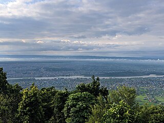
Pokhara is a metropolitan city in central Nepal, which serves as the capital of Gandaki Province and the tourism capital of Nepal. It is the second most populous city of Nepal after Kathmandu, with 599,504 inhabitants living in 120,594 households in 2021. It is the country's largest metropolitan city in terms of area. The city also serves as the headquarters of Kaski District. Pokhara is located 200 kilometres west of the capital, Kathmandu. The city is on the shore of Phewa Lake, and sits at an elevation of approximately 822 m. The Annapurna Range, with three out of the ten highest peaks in the world—Dhaulagiri, Annapurna I and Manaslu—is within 15–35 mi (24–56 km) of the valley.

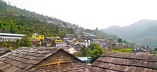
Kaski District, a part of Gandaki Province, is one of the seventy-seven districts of Nepal. The name is disambiguated from Kaskikot, the ancient Kaski Kingdom.
Bharatpur is a city in south central Nepal. It is the third most populous city of Nepal after Kathmandu and Pokhara with 369,377 inhabitants in 2021. It is also the second largest metropolitan city in Nepal by area. It is the district headquarter of the Chitwan District.
Arba Vijaya is a very old residential area in Pokhara sub-metropolitan city in Kaski District in the Gandaki Zone of northern-central Nepal. At the 1991 Nepal census, it had a population of 3,446 persons living in 714 individual households. The village is located in the Annapurna Himalayan region. It can be reached from Pokhara by 2 hours of walking or a 30-minute drive. The village has many natural sources, most of people living at villages are Brahmin, chettri, Gurung, Bishwakarma, Pariyar caste.
Armala is a town and sub-metropolitan city in the Kaski District of the Gandaki Zone of northern-central Nepal. In the 1991 Nepal census, it had a population of 4,921 people living in 1,012 households.

Ghandruk is a Village Development Committee in the Kaski District of the Gandaki Province of Nepal. Situated 32 km north-west to Pokhara, the village is readily accessible by public buses and private taxis from the provincial headquarter. At the time of the 1991 Nepal census, it had a population of 4,748 residents in 1,013 individual households.
Hemja is a former Village Development Committee in the north of Pokhara in Kaski District in the Gandaki Province of northern-central Nepal. In 2014, Hemja was annexed to Pokhara City as ward number 27. Hemja is now an administrative part of Pokhara Municipality ward #25. At the 2011 Nepal census, it had a population of 12,262 persons in 3,019 households.
Lahachowk is a village in Machhapuchchhre Gaunpalika, in the Kaski District, in the Gandaki Zone of northern-central Nepal. According to the 2011 National Population and Housing Census, it had a population of 3,129 in 829 individual households.
Puranchaur is a former Village Development Committee in Kaski District in the Gandaki Province of northern-central Nepal. It is now annexed to Pokhara metropolitan city, and is ward no. 19 of it. At the 2011 Nepal census, it had a population of 3,597 persons in 865 individual households.
Salyan is a town and Village Development Committee in Kaski District in the Gandaki Zone of northern-central Nepal. At the time of the 1991 Nepal census it had a population of 3,254 persons living in 665 individual households.
Kaskikot, commonly known as Kaski, is a Ward no. 24 of the Pokhara metropolitan city. It was earlier a part of the village development committee in Kaski District, a region in northern-central Nepal.
The Chhantyal are an indigenous people of Nepal. Chhantyals are considered an indigenous group by the Government of Nepal. Most of the Chhantyal dwellings are concentrated in the western part of the country. Baglung and Myagdi are two districts in the Dhaulagiri Zone where most of the Chhantyals are living. Other districts with Chhantyal habitation include Mustang, Gulmi, Rukum, and Parbat. Nowadays, owing to the migration trend there is a notable population of the Chhantyals in Kathmandu Valley, Pokhara, Rupandehi, Kaski, Dang and Chitwan districts. According to a survey conducted by its sole organization, Nepal Chhantyal Organization, the total population is 16,093 and 1,602 households. Traditionally Chhantyals have been living with other castes in harmony. In some villages Chhantyals are a major group whereas in other villages they are a minority. Chhantyals have their own culture, tradition, rituals, language, and religion.

Sipora Gurung is a Nepalese national women athlete, volleyball player, actress and beauty pageant winner. She is top 5 finalist of Miss Nepal 2013 & winner of Miss Talent. She was born and raised in Pokhara. She is the youngest daughter of Moti Lal Gurung and Seti Ghising Gurung. She got recognition as the best volleyball player of Nepal at the age of 16. At the age of 13, she became the youngest player in 10th South Asian Games held in Sri Lanka, also won bronze medal for Nepal. She sustained knee injury during a volleyball match at age 18 and had since been unable to play and was out of court. She was also the Nepal champion of 200m and 400m. Her name translates beautiful bird in Hebrew language.

Mahendra Cave is a cave located in Pokhara-16,batulechaur, Kaski district, close to the Kali khola, is a large limestone cave. It is a rare example of a cave system in Nepal containing stalagmites and stalactites. This show cave attracts thousands of tourists every year. A statue of Hindu lord Shiva can be found inside the cave.

Gandaki Province ), is one of the seven federal provinces established by the current constitution of Nepal which was promulgated on 20 September 2015. Pokhara is the province's capital city. It borders the Tibet Autonomous Region in Southwest China to the north, Bagmati Province to the east, Karnali Province to the west, and Lumbini Province and Bihar of India to the south. The total area of the province is 21,504 km2 - constituting 14.57% of Nepal's total area. According to the latest census, the population of the province was 2,479,745. The newly elected Provincial Assembly adopted Gandaki Province as the permanent name by replacing its initial name Province No. 4 on 27 April 2023. Surendra Raj Pandey is the present chief minister of Gandaki Province.
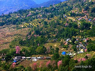
Serachaur सेराचौर is a village which is located in Kaski District, Gandaki Province, Nepal. The word Sera refers to a plain land which is used to farm and supply food to a palace and Chaur means a grassy land. First settlers of this village were Adhikari Family. It is a part of the Annapurna Gaunpalika ward number- 2, Kaski, Nepal. Pastly the village was part of Dhikurpokhari V.D.C but later the Ministry of Federal Affairs and Local Development (Nepal) dissolved the existing village development committees and announced the establishment of this new local body. Visitors can take the Baglung Highway, Kaskikot road and other existing trails to reach here. Concrete pavement is recent installation to the road.
Bhairabi Rural Municipality is a rural municipality located in Dailekh District of Karnali Province of Nepal. The total area of the rural municipality is 110.46 square kilometres (42.65 sq mi) and the total population of the rural municipality as of 2011 Nepal census is 21,233 individuals. The rural municipality is divided into total 7 wards. A small portion of Dullu municipality with Bhairi Kalikathum, Kusapani, Rawalkot and Kasikandh Village development committees were incorporated to form this new rural municipality. The headquarters of the municipality is situated at Bhairi Kalikathum.

Dakneshwori Municipality is located in Saptari District in Madhesh Province of Nepal. It was formed in 2016 occupying current 10 sections (wards) merging previous Kabilasha, Hariraha, Tarhi, Bhuthi, Pato, Aurahi, Brahampur, Gamahariya Parwaha, Patthargada and Banaula VDCs. It occupies an area of 69.11 km2 with a total population of 44,782. Dakneshwori Municipality is named after the famous temple Dakneshwori Bhagwati located at ward no. 5, Pato.
Annapurna Rural Municipality, Kaski is a Gaunpalika in Kaski District in Gandaki Province of Nepal named after the Annapurna Mountain. On 12 March 2017, the Government of Nepal implemented a new local administrative structure. With the implementation of the new local administrative structure, VDSs have been replaced with municipal and village councils. Annapurna Gaupalika is one of these 753 local units.


