Kaski District, a part of Gandaki Province, is one of the seventy-seven districts of Nepal. The name is disambiguated from Kaskikot, the ancient Kaski Kingdom.
Lekhnath was a municipality in Kaski District in the Gandaki Province of northern-central Nepal, about 180 km west of Kathmandu. It has now been merged into Pokhara sub-metropolitan city to form Pokhara metropolis. Pokhara Valley was politically divided between Pokhara city and Lekhnath which occupied the eastern half of the valley. There were 18 wards in total in Lekhnath municipality before the merger, with a VDC Bharat Pokhari that had been added at a later stage.
Arba Vijaya is a very old residential area in Pokhara sub-metropolitan city in Kaski District in the Gandaki Zone of northern-central Nepal. At the 1991 Nepal census, it had a population of 3,446 persons living in 714 individual households. The village is located in the Annapurna Himalayan region. It can be reached from Pokhara by 2 hours of walking or a 30-minute drive. The village has many natural sources, most of people living at villages are Brahmin, chettri, Gurung, Bishwakarma, Pariyar caste.
Begnas is a town and Village Development Committee in Kaski District in the Gandaki Zone of northern-central Nepal. At the 1991 Nepal census, Begnas had a population of 6,803 in 1,420 individual households.
Deurali is a Village Development Committee in Kaski District of the Gandaki province of north-central Nepal. At the time of the 1991 Nepal census, it had a population of 2,882. The base camp of Mount Machapuchare is situated at a 6-hour uphill trek from the village.
Dhikurpokhari is a suburb and former Village Development Committee in Kaski District in the Gandaki Province of northern-central Nepal. At the 1991 Nepal census, it had a population of 7,392 persons in 1,427 individual households.

Dhital, formerly a village development committee in Kaski District, Gandaki Zone, is now located in Machhapuchhre rural municipality, ward number 6 in Kaski district, Gandaki Province, Nepal.The name Dhital Dhi+Tal Dhi means nepali word धि and Tal means lake it is believed that there was a lake in 18th century. At the 1991 Nepal census, it had a population of 4,121 persons in 862 individual households. Dhital is near Annapurna Himalaya and on its trekking route.

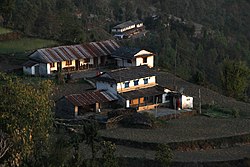
Ghandruk is a Village Development Committee in the Kaski District of the Gandaki Province of Nepal. Situated 32 km north-west to Pokhara, the village is readily accessible by public buses and private taxis from the provincial headquarter. At the time of the 1991 Nepal census, it had a population of 4,748 residents in 1,013 individual households.
Hansapur is a town and Village Development Committee in Kaski District in the Gandaki Zone of northern-central Nepal. At the 1991 Nepal census, it had a population of 4,761 persons in 956 individual households.
Kahun is a former village and Village Development Committee in Kaski District in the Gandaki Zone of northern-central Nepal. In 2015, it was annexed to Pokhara. At the time of the 2011 Nepal census it had a population of 14,716.
Lahachowk is a village in Machhapuchchhre Gaunpalika, in the Kaski District, in the Gandaki Zone of northern-central Nepal. According to the 2011 National Population and Housing Census, it had a population of 3,129 in 829 individual households.
Lumle is a town and Annapurna Rural Municipality, Kaski Kaski District in the Gandaki Zone of northern-central Nepal. At the 1991 Nepal census, it had a population of 4,685 persons in 955 individual households.
Parche is a town and Village Development Committee (VDC) in Kaski District in the Gandaki Zone of northern-central Nepal. At the 1991 Nepal census, it had a population of 3,182 persons in 669 individual households.
Ribhan is a village and Village Development Committee in Kaski District in the Gandaki Zone of northern-central Nepal. At the time of the 2001 Nepal census it had a population of 1,617 persons living in 372 individual households. Brahmin and Gurung are main ethnic groups in this village. Ribhan is mainly a settlement on the bank of Mardi river which is the main source of irrigation for people of this agriculture-based village. The forest in this village has many endangered species such as Himali red panda and leopard. Much of its forest is still unexplored as it is very remote with high and often snow-bound hills. It is a part of Annapurna Conservation Area project.
Saimarang is a town and Village Development Committee in Kaski District in the Gandaki Province of Western Nepal. At the time of the 2011 Nepal census it had a population of 1,171 persons living in 309 individual households. Saimarang owns a famous Temple Bhagawati Temple and hill known as Lamtari there is a famous Devi tample called Lamtari Mai which is in front of Pokhara Valley. The Annapurna Himalayan range can be seen at the back of the village, and Begnash, Rupa and Fewa lake in the front. Also there are several adventures such as caves, rocky hills. Local people in Warchowk and Togi are working hard to make the Saimarang VDC a good place for Adventurous Tourism. The people there are very helpful.

Sarangkot is Ward 18 of Pokhara, Kaski District, Nepal, after it was merged into the city in 2015. It is a popular tourist destination for those who arrive in Pokhara. At the 1991 Nepal census it had a total population of 5,060 with 1,010 individual households.
Kaskikot, commonly known as Kaski, is a Ward no. 24 of the Pokhara metropolitan city. It was earlier a part of the village development committee in Kaski District, a region in northern-central Nepal.

Paundur (पाउँदुर) is a central village in Kaski district of Gandaki Province of Nepal. It lies about 28 km west of the Pokhara valley and 38 km east of Kushma, Parbat. It is a part of ward no. 3 of Annapurna Gaupalika of Gandaki Province of Nepal, and was the ward no.5 and 8 of the former Dhikurpokhari VDC.It lies west of Nagdanda; nearest sub urban area. There are more than 100 houses in this village.
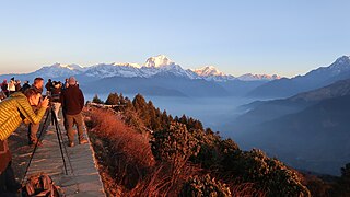
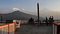
Poon Hill is a hill station overlooking the Annapurna Massif range and Dhaulagiri mountain range, located on border of Myagdi District and Kaski District in Gandaki Province of Nepal. This lookout is the key viewpoint in the Ghorepani Poon Hill trek. Mountains such as an Annapurna 8,091m, Dhaulagiri 8,127, Annapurna South 7,219 Meter, Machapuchare 6,993 Meter, Hinchuli, Annapurna III, Dhampus peak, Dhulagiri II, and many other tall peaks can be seen from here.
Annapurna Rural Municipality, Kaski is a Gaunpalika in Kaski District in Gandaki Province of Nepal named after the Annapurna Mountain. On 12 March 2017, the Government of Nepal implemented a new local administrative structure. With the implementation of the new local administrative structure, VDSs have been replaced with municipal and village councils. Annapurna Gaupalika is one of these 753 local units.