Lumle लुम्ले | |
---|---|
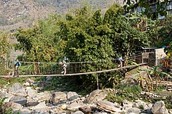
![]() Bridge over Dhoti Khola | |
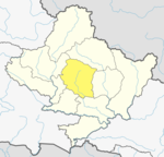
Coordinates: 28°21′N83°50′E / 28.35°N 83.83°E | |
Country | ![]() |
Zone | Gandaki Zone |
District | Kaski District |
Population (1991) | |
• Total | 4,685 |
Time zone | UTC+5:45 (NST) |
Area code | 061 |
Lumle is a town and Annapurna Rural Municipality, Kaski Kaski District in the Gandaki Zone of northern-central Nepal.[ clarification needed ] At the 1991 Nepal census, it had a population of 4,685 persons in 955 individual households. [1]
Lumle is well known for its agricultural centre on a hillside above the village founded in 1968 to train British Gurkha ex-servicemen farmers. Its role was expanded in 1975 to benefit the communities from which Gurkhas were recruited in Mid-West Hills. It is now part of Nepal Agricultural Research Council. [2]
Climate data for Lumle, elevation 1,738 m (5,702 ft), (1991–2020 normals, extremes 1969–2017) | |||||||||||||
---|---|---|---|---|---|---|---|---|---|---|---|---|---|
Month | Jan | Feb | Mar | Apr | May | Jun | Jul | Aug | Sep | Oct | Nov | Dec | Year |
Record high °C (°F) | 21.5 (70.7) | 22.5 (72.5) | 25.7 (78.3) | 29.5 (85.1) | 31.0 (87.8) | 29.5 (85.1) | 31.0 (87.8) | 28.5 (83.3) | 28.5 (83.3) | 29.6 (85.3) | 25.5 (77.9) | 22.0 (71.6) | 31.0 (87.8) |
Mean daily maximum °C (°F) | 13.9 (57.0) | 15.8 (60.4) | 19.8 (67.6) | 22.8 (73.0) | 23.5 (74.3) | 24.0 (75.2) | 23.8 (74.8) | 23.9 (75.0) | 23.3 (73.9) | 21.6 (70.9) | 18.4 (65.1) | 15.2 (59.4) | 20.5 (68.9) |
Daily mean °C (°F) | 9.3 (48.7) | 11.2 (52.2) | 14.7 (58.5) | 17.6 (63.7) | 18.9 (66.0) | 20.4 (68.7) | 20.8 (69.4) | 20.8 (69.4) | 19.9 (67.8) | 17.3 (63.1) | 13.9 (57.0) | 10.7 (51.3) | 16.3 (61.3) |
Mean daily minimum °C (°F) | 4.7 (40.5) | 6.5 (43.7) | 9.5 (49.1) | 12.4 (54.3) | 14.3 (57.7) | 16.7 (62.1) | 17.8 (64.0) | 17.6 (63.7) | 16.5 (61.7) | 12.9 (55.2) | 9.3 (48.7) | 6.1 (43.0) | 12.0 (53.6) |
Record low °C (°F) | −1.2 (29.8) | −0.3 (31.5) | 0.6 (33.1) | 4.8 (40.6) | 5.5 (41.9) | 9.9 (49.8) | 10.0 (50.0) | 10.2 (50.4) | 10.0 (50.0) | 4.5 (40.1) | 3.0 (37.4) | 0.5 (32.9) | −1.2 (29.8) |
Average precipitation mm (inches) | 34.9 (1.37) | 51.4 (2.02) | 68.5 (2.70) | 122.8 (4.83) | 309.4 (12.18) | 866.0 (34.09) | 1,473.2 (58.00) | 1,419.4 (55.88) | 903.2 (35.56) | 208.0 (8.19) | 19.7 (0.78) | 15.5 (0.61) | 5,492 (216.22) |
Source: Department of Hydrology and Meteorology [3] [4] |