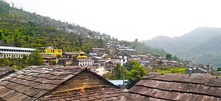
Myanglung is a municipality and the district headquarters of Terhathum District of Koshi Province in eastern Nepal. The "myang" means cat and "lung" means stone in Limbu language.The story is that the cat (myang) in ancient time, pawed the stone (lung) in anger. The municipality is situated at an elevation of about 1500 metres above sea level. Myanglung was converted into a municipality from a village development committee on 18 May 2014, merging the existing village development committees of Myanglung, Piple, Jirikhimti, Ambung, Sabla and Tamphula. According to the census of 2011 the total population of Myanglung is 19,659 including five VDCs.
Thakre is a Gaupalika(Nepali: गाउपालिका ; gaupalika)(Formerly: village development committee) in Dhading District. The local body was formed by merging four VDCs namely Bhumesthan, Tasarphu, Thakre, Kebalpur and Goganpani, Bagmati. It has eleven wards. The population was 32,914, according to data collected in the 2017 Nepalese local elections.
Manahari is a Rural Municipality in Makwanpur District in the Bagmati Province of Nepal. At the time of the 1991 Nepal census it had a population of 10,013 people living in 1789 individual households.
Shankharapur is a municipality in Kathmandu District in Bagmati Province of Nepal that was established on 2 December 2014 by merging the former Village development committees Bajrayogini, Karkigaun, Bhulbu, Indrayani, Lapsiphedi, Naglebhare, Pukhulachhi and Suntol. The office of the municipality is that of the former Pukhulachhi village development committee in the old Newari town of Sankhu.
Palungtar is a municipality in Gorkha District in Gandaki Province, central Nepal. It is made up of the seven former Village Development Committees Aanppipal, Chyangli, Dhuwakot, Gaikhur, Khoplang, Mirkot and Palumtar. It lies on the bank of Marshyangdi River. The Government of Nepal plans to make Palungtar the country's first Smart City. At the time of the 2011 Nepal census it had a population of 38,174 people living in 9,924 individual households.
Panchkhapan (Nepali: पाँचखप्पन) is an urban municipality out of five urban municipalities of Sankhuwasabha District in Koshi Province of Nepal. It lies on 87°12'12" E to 87°26'45" E Longitude and 27°17'37.4" N to 27°24'38" N Latitude. The municipality was established on 3 March 2017 merging former VDCs: Syabun, Jaljala and Wana. The area of the municipality is 148.03KM2 and according to 2011 census of Nepal the population of the municipality is 17,521.
Dharmadevi is a municipality in Sankhuwasabha District of Koshi Province in Nepal. It is a municipality out of 5 municipalities in Sankhuwasabha District. Total area of the municipality is 133 km (83 mi) and according to 2011 census of Nepal, the population of this municipality is 18,235. The municipality was established in March 2017 merging some former VDCs: e.g. Aankhibhui, Mamling and Tamaphok. The municipality is divided into 9 wards. The headquarter of the municipality is in Tamaphok.
Madi is a municipality in Sankhuwasabha District of Koshi Province in Nepal. It is a municipality out of 5 municipalities in Sankhuwasabha District. Total area of the municipality is 110.10 km (68.41 mi) and according to 2011 census of Nepal, the population of this municipality is 14,470. The municipality was established in March 2017 merging some former VDCs: e.g. Madi Mulkharka, Madi Rambeni and Mawadin. The municipality is divided into 13 wards. The headquarter of the municipality is in Okharbote.
Mahalaxmi is a municipality in Dhankuta District of Koshi Province in Nepal. It is a municipality out of three urban municipalities in Dhankuta District. Total area of the municipality is 126.3 km (78.5 mi) and according to 2011 census of Nepal, the population of this municipality is 24,800. The municipality is divided into nine wards. The headquarter of the municipality is in Jitpur Bazar.
Gokulganga Rural Municipality is a Rural municipality in Ramechhap District of Bagmati Province in Nepal.
Chhathar Jorpati is a rural municipality (gaunpalika) out of four rural municipality located in Dhankuta District of Koshi Province of Nepal. There are a total of 7 municipalities in Dhankuta in which 3 are urban and 4 are rural.
Savapokhari is a rural municipality (gaunpalika) out of five rural municipality located in Sankhuwasabha District of Koshi Province of Nepal. There are a total of 10 municipalities in Sankhuwasabha in which 5 are urban and 5 are rural.
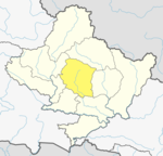
Chhathar is a rural municipality (gaunpalika) out of four rural municipality located in Tehrathum District of Koshi Province of Nepal. There are a total of 6 municipalities in Tehrathum in which 2 are urban and 4 are rural.
Mandandeupur is a municipality in Kavrepalanchok District of Bagmati Province of Nepal.
Rupa Rural Municipality (Rupa Gaupalika) (Nepali: रुपा गाउँपालिका) is a Gaunpalika in Kaski District in Gandaki Province of Nepal. On 12 March 2017, the government of Nepal implemented a new local administrative structure, in which VDCs have been replaced with municipal and Village Councils. Rupa is one of these 753 local units.
Madi Rural Municipality is a Gaunpalika in Kaski District in Gandaki Province of Nepal. On 12 March 2017, the government of Nepal implemented a new local administrative structure, with the implementation of the new local administrative structure, VDSs have been replaced with municipal and Village Councils. Madi is one of these 753 local units.
Annapurna Rural Municipality, Kaski is a Gaunpalika in Kaski District in Gandaki Province of Nepal named after the Annapurna Mountain. On 12 March 2017, the Government of Nepal implemented a new local administrative structure. With the implementation of the new local administrative structure, VDSs have been replaced with municipal and village councils. Annapurna Gaupalika is one of these 753 local units.
Gharapjhong Rural Municipality (Gharapjhong Gaupalika) (Nepali: घरपझोङ गाउँपालिका) is a Gaunpalika, or rural municipality, in Mustang district in Gandaki Province of Nepal. On 12 March 2017, the government of Nepal implemented a new local administrative structure, in which Village Development Committees were replaced with municipal and Village Councils. Gharapjhong is one of these 753 local units.
Arughat Rural Municipality is a Gaunpalika in Gorkha District in Gandaki Province of Nepal. It is divided into 10 wards. On 12 March 2017, the government of Nepal implemented a new local administrative structure, with the implementation of the new local administrative structure, VDCs have been replaced with municipal and Village Councils. Arughat is one of these 753 local units.
Benighat Rorang is a rural municipality located within the Dhading District of the Bagmati Province of Nepal. The rural municipality spans 29.17 square kilometres (11.26 sq mi), with a total population of 31,475 according to a 2011 Nepal census.