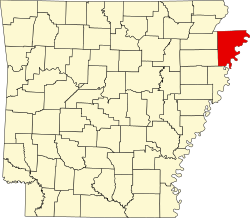
Armorel, Arkansas | |
---|---|
Coordinates: 35°55′20″N89°48′03″W / 35.92222°N 89.80083°W | |
Country | United States |
State | Arkansas |
County | Mississippi |
Established | 1899 |
Area | |
• Total | 1.48 sq mi (3.8 km2) |
• Land | 1.39 sq mi (3.6 km2) |
• Water | 0.09 sq mi (0.2 km2) |
Elevation | 259 ft (79 m) |
Population | |
• Total | 312 |
• Density | 223.8/sq mi (86.4/km2) |
Time zone | UTC-6 (Central (CST)) |
• Summer (DST) | UTC-5 (CDT) |
ZIP code | 72310 |
Area code | 870 |
FIPS code | 05-02230 |
GNIS feature ID | 2805619 [2] |
Armorel is an unincorporated community and census-designated place (CDP) in Mississippi County, Arkansas, United States. As of the 2020 census, it had a population of 312. [3] It is in a largely rural area with most of its land devoted to forests and farms. Most of the town lies between Arkansas highways 18 and 312. The town's name was formed from the abbreviations of Arkansas and Missouri, along with the first three initials of its founder, Wilson.
The town was founded in 1899 by lumber magnate and president of Lee Wilson and Company, R.E.L. Wilson as one of his many company holdings. By 1900, he was operating one of his companies, the Beall Lumber Company, in the community. [4] The lumber mill and nearly three million feet of cut lumber later burned to the ground on June 10, 1902. [5]
By 1904, the community received a rail connection when the Chickasawba Railroad completed it's line from Blytheville to Barfield Landing on the Mississippi River. This line was soon after consolidated into the Jonesboro, Lake City, and Eastern Railroad. [6]
In 1924, the community of Armorel hosted a division of Marcus Garvey's Universal Negro Improvement Association. [7]
Public education for early childhood, elementary and secondary education is available from the Armorel School District, [8] that leads to graduation from Armorel High School.
Census | Pop. | Note | %± |
---|---|---|---|
2020 | 312 | — | |
U.S. Decennial Census [9] 2020 [10] |
Race / Ethnicity (NH = Non-Hispanic) | Pop 2020 [10] | % 2020 |
---|---|---|
White alone (NH) | 272 | 87.18% |
Black or African American alone (NH) | 23 | 7.37% |
Native American or Alaska Native alone (NH) | 0 | 0.00% |
Asian alone (NH) | 4 | 1.28% |
Pacific Islander alone (NH) | 0 | 0.00% |
Some Other Race alone (NH) | 0 | 0.00% |
Mixed Race or Multi-Racial (NH) | 4 | 1.28% |
Hispanic or Latino (any race) | 9 | 2.88% |
Total | 312 | 100.00% |
Mississippi County is the easternmost county in the U.S. state of Arkansas. As of the 2020 census, the population was 40,685. There are two county seats, Blytheville and Osceola. The county is named for the Mississippi River which borders the county to the east. Mississippi County is part of the First Congressional District in Arkansas.
Keiser is a city in Mississippi County, Arkansas, United States. The population was 751 at the 2020 census.
Marie is a town in Mississippi County, Arkansas, United States. It was founded by the R.E.L. Wilson cotton company. The population was 108 at the 2020 census.
Victoria is a town in Mississippi County, Arkansas, United States. The population was 20 as of the 2020 census, down from 37 in 2010. It is named after a sister of the town's founder, Robert E. Lee Wilson.
Wilson is a city in Mississippi County, Arkansas, United States. The community is located in the Arkansas Delta and is surrounded by fertile cropland historically used to produce cotton. Wilson started as a company town in 1886 by Robert E. Lee Wilson, who would build a cotton empire and run it from the city. The Wilson Company would become so successful that all of the town's buildings were rebuilt in the Tudor Revival architectural style following Wilson's son's honeymoon to England in 1925. Wilson incorporated in 1959, becoming a town with public roads and municipal government. The extensive property holdings of the Lee Wilson and Company remained in the Wilson family until 2010. The community has seen a rapid decline in economic activity and population since the advent of mechanization on the farm, reducing the need for manual labor to produce cotton. The population was 766 at the 2020 census, down from 903 at the 2010 census.
Kirby is an unincorporated census-designated place in northern Pike County, Arkansas, United States. The community lies on U.S. Route 70; it is located halfway between Daisy and Glenwood. Per the 2020 census, the population was 721.
Bogue Chitto is an unincorporated community and census-designated place (CDP) in Lincoln County, Mississippi, United States. As of the 2020 census, it had a population of 437. Bogue Chitto is the only municipal hamlet in the state of Mississippi.
Kokomo is a census-designated place and unincorporated community in Marion County, Mississippi, United States. As of the 2020 census, the first year it was listed as a census-designated place, it had a population of 150.
Benndale is a census-designated place (CDP) and unincorporated community in George County, Mississippi, near the intersection of State Highways 26 and 57. It is part of the Pascagoula Metropolitan Statistical Area. Prior to the creation of George County, Benndale was located in Jackson County. It became a CDP in the 2020 United States census, with a population of 65.
Rena Lara is a census-designated place and unincorporated community located along Mississippi Highway 1 in southwestern Coahoma County, Mississippi, United States. Rena Lara is located on the former Riverside Division of the Yazoo and Mississippi Valley Railroad. Rena Lara was once home to two general stores, two grocery stores, and the Richardson and May Land & Planting Company.
Ovett is a census-designated place and unincorporated community in southeastern Jones County, Mississippi. Ovett is part of the Laurel Micropolitan Statistical Area.
Maysville is an unincorporated community and census-designated place (CDP) in Benton County, Arkansas, United States. It is the westernmost settlement in the state of Arkansas. Per the 2020 census, the population was 117. It is located in the Northwest Arkansas region.
Bond is a census-designated place and unincorporated community in northern Stone County, Mississippi, United States. The community is situated approximately 3 miles (4.8 km) north of Wiggins on U.S. Route 49, and is part of the Gulfport-Biloxi metropolitan area. It was first named as a CDP in the 2020 Census which listed a population of 506.
Beirne is an unincorporated community and census-designated place (CDP) in southern Clark County, Arkansas, United States. It was first listed as a CDP in the 2020 census with a population of 36.
Waterford is a census-designated place and unincorporated community in Marshall County, Mississippi, United States. It is a small town located between Holly Springs and Oxford on Highway 7.
Leaf is a census-designated place and unincorporated community in Greene County, Mississippi, United States.
Stewart is a census-designated place and unincorporated community in Montgomery County, Mississippi, United States. As of the 2020 census, it had a population of 99.
Fernwood is a census-designated place and unincorporated community in Pike County, Mississippi, United States. Its ZIP code is 39635.
Bethlehem is a census-designated place and unincorporated community in Marshall County, Mississippi, United States. Its ZIP code is 38659.
Halley is an unincorporated community and census-designated place (CDP) in Desha County, Arkansas, United States. It was first listed as a CDP in the 2020 census with a population of 44.