Burdette, Arkansas

Last updated

Burdette, Arkansas
Burdette-Farms-and-post-office-ar.jpg
Post office and Burdette Farms office
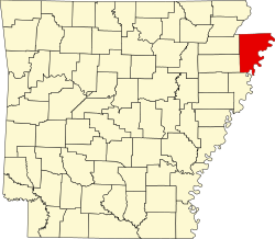
Mississippi County Arkansas Incorporated and Unincorporated areas Burdette Highlighted 0509880.svg
Location in Mississippi County, Arkansas
Coordinates: 35°48′55″N89°56′47″W / 35.81528°N 89.94639°W / 35.81528; -89.94639
Country United States
State Arkansas
County Mississippi
IncorporatedMay 10, 1905
Named for Alfred Burdette Wolverton
Area
[1]
  Total0.74 sq mi (1.91 km2)
  Land0.74 sq mi (1.91 km2)
  Water0.00 sq mi (0.00 km2)
Elevation
[2]
240 ft (70 m)
Population
 (2020) [3]
  Total140
  Density189.96/sq mi (73.31/km2)
Time zone UTC-6 (Central (CST))
  Summer (DST) UTC-5 (CDT)
ZIP code
72321
Area code 870
FIPS code 05-09880
GNIS feature ID2405344 [2]

Burdette is a town in Mississippi County, Arkansas, United States. The population was 140 at the 2020 census, [3] down from 191 in 2010.

Contents

History

Burdette has its origins as a company town established by the Three States Lumber Company in the early 1900s. Incorporated in 1905, the town was named for Alfred Burdette Wolverton, an early logger in the area. Three States completed a large sawmill in Burdette in 1906. [4] In 1907, the Blytheville, Burdette and Mississippi River Railway was formed to build a line from Wolverton Landing, on the Mississippi River, northward to Blytheville. This line also included a branch to Burdette. [5]

A large agricultural operation, the Burdette Plantation, developed alongside the lumber operations. Beginning in the 1920s, these farms were utilized by the University of Arkansas for agricultural research focused on the improvement of cotton and corn yields. Several new cotton varieties, such as "Burdette Express" and "Burdette Lone Star", were developed in the Burdette area. [4]

Geography

Burdette is located in northeastern Mississippi County at 35°49′8″N89°56′35″W / 35.81889°N 89.94306°W / 35.81889; -89.94306 (35.856818, -90.040113). [6] The town is concentrated along Arkansas Highway 148, 5 miles (8 km) north of Luxora and 9 miles (14 km) south of Blytheville, and about 5 miles (8 km) northwest of the Mississippi River. The town's municipal boundaries stretch westward along AR 148 to Interstate 55 and eastward to U.S. Route 61.

According to the United States Census Bureau, Burdette has a total area of 0.74 square miles (1.92 km2), all land. [1]

Demographics

Historical population
CensusPop.Note
1920 100
1930 15555.0%
1940 110−29.0%
1950 12210.9%
1960 115−5.7%
1970 17350.4%
1980 32889.6%
1990 148−54.9%
2000 129−12.8%
2010 19148.1%
2020 140−26.7%
U.S. Decennial Census [7]
2014 Estimate [8]

As of the 2010 United States Census, there were 191 people living in the town. The racial makeup of the town was 70.7% White, 20.9% Black, and 8.4% were Hispanic or Latino of any race.

As of the census [9] of 2000, there were 129 people, 52 households, and 35 families living in the town. The population density was 75.5/km2 (194.5/mi2). There were 57 housing units at an average density of 33.3/km2 (85.9/mi2). The racial makeup of the town was 82.17% White, 17.05% Black or African American, and 0.78% from two or more races.

There were 52 households, out of which 25.0% had children under the age of 18 living with them, 57.7% were married couples living together, 3.8% had a female householder with no husband present, and 30.8% were non-families. 30.8% of all households were made up of individuals, and 1.9% had someone living alone who was 65 years of age or older. The average household size was 2.48 and the average family size was 3.06.

In the town, the population was spread out, with 23.3% under the age of 18, 8.5% from 18 to 24, 25.6% from 25 to 44, 35.7% from 45 to 64, and 7.0% who were 65 years of age or older. The median age was 40 years. For every 100 females, there were 101.6 males. For every 100 females age 18 and over, there were 115.2 males.

The median income for a household in the town was $40,625, and the median income for a family was $49,375. Males had a median income of $29,500 versus $9,250 for females. The per capita income for the town was $18,958. There were 10.3% of families and 11.2% of the population living below the poverty line, including 11.1% of under eighteens and none of those over 64.

Education

The town is served by Blytheville School District, [10] including Blytheville High School.

The Burdette school district merged into the Blytheville district in 1971. [11]

Related Research Articles

<span class="mw-page-title-main">Mississippi County, Arkansas</span> County in Arkansas, United States

Mississippi County is the easternmost county in the U.S. state of Arkansas. As of the 2020 census, the population was 40,685. There are two county seats, Blytheville and Osceola. The county is named for the Mississippi River which borders the county to the east. Mississippi County is part of the First Congressional District in Arkansas.

<span class="mw-page-title-main">Menifee, Arkansas</span> Town in Arkansas, United States

Menifee is a town in Conway County, Arkansas, United States. The population was 302 at the 2010 census.

<span class="mw-page-title-main">Caraway, Arkansas</span> City in Arkansas, United States

Caraway is a city in Craighead County, Arkansas, United States. The population was 1,279 at the 2010 census. It is included in the Jonesboro, Arkansas Metropolitan Statistical Area.

<span class="mw-page-title-main">Dyer, Arkansas</span> City in Arkansas, United States

Dyer is a city in Crawford County, Arkansas, United States. It is part of the Fort Smith, Arkansas-Oklahoma Metropolitan Statistical Area. The population was 876 at the 2010 census.

<span class="mw-page-title-main">Anthonyville, Arkansas</span> Town in Arkansas, United States

Anthonyville is a town in Crittenden County, Arkansas, United States. The population was 161 at the 2010 census, down from 250 in 2000.

<span class="mw-page-title-main">Crawfordsville, Arkansas</span> Town in Arkansas, United States

Crawfordsville, historically Crawfordville, is a town in Crittenden County, Arkansas, United States. The population was 479 at the 2010 census.

<span class="mw-page-title-main">Edmondson, Arkansas</span> Town in Arkansas, United States

Edmondson is a town in Crittenden County, Arkansas, United States. The population was 427 at the 2010 census.

<span class="mw-page-title-main">Gilmore, Arkansas</span> City in Arkansas, United States

Gilmore is a city in Crittenden County, Arkansas, United States. Per the 2020 census, the population was 176.

<span class="mw-page-title-main">Horseshoe Lake, Arkansas</span> Town in Arkansas, United States

Horseshoe Lake is a town in Crittenden County, Arkansas, United States. The population was 264 at the 2020 census.

<span class="mw-page-title-main">Enola, Arkansas</span> Town in Arkansas, United States

Enola is a town in Faulkner County, Arkansas, United States. It is part of the Central Arkansas region. The population was 318 at the 2020 census.

<span class="mw-page-title-main">Twin Groves, Arkansas</span> Town in Arkansas, United States

Twin Groves is a town in northwestern Faulkner County, Arkansas, United States. The name of the town comes from two neighboring communities — Solomon Grove and Zion Grove — which joined to incorporate as a town in 1991. The town's population was 335 at the 2010 census, up from 276 at the 2000 census. Twin Groves is part of the Central Arkansas region.

<span class="mw-page-title-main">Mount Pleasant, Arkansas</span> Town in Arkansas, United States

Mount Pleasant is a town in Izard County, Arkansas, United States. As of the 2020 census, the town population was 353.

<span class="mw-page-title-main">Jacksonport, Arkansas</span> Town in Arkansas, United States

Jacksonport is a town in Jackson County, Arkansas, United States, along the White River at its confluence with the Black River. The population was 212 at the 2010 census.

<span class="mw-page-title-main">Bassett, Arkansas</span> Town in Arkansas, United States

Bassett is a town in Mississippi County, Arkansas, United States. The population was 124 at the 2020 census, down from 173 in 2010.

<span class="mw-page-title-main">Birdsong, Arkansas</span> Town in Arkansas, United States

Birdsong is a town in Mississippi County, Arkansas, United States. The population was 32 at the 2020 census, down from 41 in 2010.

<span class="mw-page-title-main">Dell, Arkansas</span> Town in Arkansas, United States

Dell is a town in Mississippi County, Arkansas, United States. The population was 194 at the 2020 census.

<span class="mw-page-title-main">Luxora, Arkansas</span> City in Arkansas, United States

Luxora is a city in Mississippi County, Arkansas, United States. The population was 942 at the 2020 census, down from 1,178 in 2010.

<span class="mw-page-title-main">Marie, Arkansas</span> Town in Arkansas, United States

Marie is a town in Mississippi County, Arkansas, United States. It was founded by the R.E.L. Wilson cotton company. The population was 108 at the 2020 census.

<span class="mw-page-title-main">Victoria, Arkansas</span> Town in Arkansas, United States

Victoria is a town in Mississippi County, Arkansas, United States. The population was 20 as of the 2020 census, down from 37 in 2010. It is named after a sister of the town's founder, Robert E. Lee Wilson.

<span class="mw-page-title-main">Caldwell, Arkansas</span> Town in Arkansas, United States

Caldwell is a town in St. Francis County, Arkansas, United States. The population was 555 at the 2010 census, an increase from 465 in 2000.

References

  1. 1 2 "2021 U.S. Gazetteer Files: Arkansas". United States Census Bureau. Retrieved June 21, 2022.
  2. 1 2 U.S. Geological Survey Geographic Names Information System: Burdette, Arkansas
  3. 1 2 "P1. Race – Burdette town, Arkansas: 2020 DEC Redistricting Data (PL 94-171)". U.S. Census Bureau. Retrieved June 21, 2022.
  4. 1 2 Jami Forrester, "Burdette (Mississippi County)," Encyclopedia of Arkansas History and Culture, 2018.
  5. Strouse, L.K. (1926). Interstate Commerce Commission Reports: Reports and Decisions of the Interstate Commerce Commission of the United States. Vol. 108. Interstate Commerce Commission. p. 1.
  6. "US Gazetteer files: 2010, 2000, and 1990". United States Census Bureau. February 12, 2011. Retrieved April 23, 2011.
  7. "Census of Population and Housing". Census.gov. Retrieved June 4, 2015.
  8. "Annual Estimates of the Resident Population for Incorporated Places: April 1, 2010 to July 1, 2014". Archived from the original on May 22, 2015. Retrieved June 4, 2015.
  9. "U.S. Census website". United States Census Bureau . Retrieved January 31, 2008.
  10. "SCHOOL DISTRICT REFERENCE MAP (2010 CENSUS): Mississippi County, AR" (PDF). 2010 U.S. Census . U.S. Census Bureau . Retrieved November 5, 2019.
  11. Goatcher, Truett (January 1999). "School District Consolidation Will Save Millions of Dollars: Fact of Myth?" (PDF). Arkansas Association of Educational Administrators. p. 13 (PDF p. 16/27).