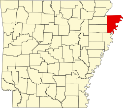
Bassett, Arkansas | |
---|---|
Coordinates: 35°32′10″N90°7′34″W / 35.53611°N 90.12611°W | |
Country | United States |
State | Arkansas |
County | Mississippi |
First Settled | 1860's |
Incorporated | November 26, 1965 |
Area | |
• Total | 0.24 sq mi (0.63 km2) |
• Land | 0.24 sq mi (0.63 km2) |
• Water | 0.00 sq mi (0.00 km2) |
Elevation | 236 ft (72 m) |
Population | |
• Total | 124 |
• Density | 506.12/sq mi (195.43/km2) |
Time zone | UTC-6 (Central (CST)) |
• Summer (DST) | UTC-5 (CDT) |
ZIP code | 72313 |
Area code | 870 |
FIPS code | 05-03940 |
GNIS feature ID | 2405212 [2] |
Bassett is a town in Mississippi County, Arkansas, United States. The population was 124 at the 2020 census, [3] down from 173 in 2010.
Prior to the late 1860's Bassett Cemetery was established in the area. The oldest grave marker in the cemetery is dated 1868. In 1903, the St. Louis & San Francisco Railway built a line through the town, but a depot was constructed in neighboring Joiner, Arkansas instead. The town received a post office the following year. [4]
Bassett is located in southern Mississippi County at 35°32′9″N90°7′34″W / 35.53583°N 90.12611°W (35.535942, -90.126052). [5] U.S. Route 61 passes through the town, leading northeast 16 miles (26 km) to Osceola, the county seat, and southwest 14 miles (23 km) to Turrell. Arkansas Highway 181 runs west 2 miles (3 km) from the center of Bassett to Interstate 55 at Exit 36.
According to the United States Census Bureau, the town has a total area of 0.25 square miles (0.65 km2), all land. [1]
Census | Pop. | Note | %± |
---|---|---|---|
1970 | 265 | — | |
1980 | 243 | −8.3% | |
1990 | 199 | −18.1% | |
2000 | 168 | −15.6% | |
2010 | 173 | 3.0% | |
2020 | 124 | −28.3% | |
U.S. Decennial Census [6] |
As of the 2010 United States Census, there were 173 people living in the town. The racial makeup of the town was 90.2% White, 8.1% Black, and 1.7% were Hispanic or Latino of any race.
As of the census [7] of 2000, there were 168 people, 71 households, and 49 families living in the town. The population density was 270.3/km2 (697.7/mi2). There were 76 housing units at an average density of 122.3/km2 (315.6/mi2). The racial makeup of the town was 94.81% White, and 5.19% from two or more races. 0.60% of the population were Hispanic or Latino of any race.
There were 71 households, out of which 32.4% had children under the age of 18 living with them, 45.1% were married couples living together, 14.1% had a female householder with no husband present, and 29.6% were non-families. 26.8% of all households were made up of individuals, and 15.5% had someone living alone who was 65 years of age or older. The average household size was 2.37 and the average family size was 2.80.
In the town, the population was spread out, with 23.2% under the age of 18, 5.4% from 18 to 24, 29.2% from 25 to 44, 25.0% from 45 to 64, and 17.3% who were 65 years of age or older. The median age was 40 years. For every 100 females, there were 88.8 males. For every 100 females age 18 and over, there were 89.7 males.
The median income for a household in the town was $31,607, and the median income for a family was $32,813. Males had a median income of $28,750 versus $21,250 for females. The per capita income for the town was $13,464. About 18.4% of families and 23.6% of the population were below the poverty line, including 36.1% of those under the age of eighteen and 9.5% of those 65 or over.
Concord is a town in Cleburne County, Arkansas, United States. The population was 244 at the 2010 census.
Menifee is a town in Conway County, Arkansas, United States. The population was 302 at the 2010 census.
Caraway is a city in Craighead County, Arkansas, United States. The population was 1,279 at the 2010 census. It is included in the Jonesboro, Arkansas Metropolitan Statistical Area.
Anthonyville is a town in Crittenden County, Arkansas, United States. The population was 161 at the 2010 census, down from 250 in 2000.
Crawfordsville, historically Crawfordville, is a town in Crittenden County, Arkansas, United States. The population was 479 at the 2010 census.
Edmondson is a town in Crittenden County, Arkansas, United States. The population was 427 at the 2010 census.
Gilmore is a city in Crittenden County, Arkansas, United States. Per the 2020 census, the population was 176.
Horseshoe Lake is a town in Crittenden County, Arkansas, United States. The population was 264 at the 2020 census.
Jennette is a town in Crittenden and St. Francis counties, Arkansas, United States. The population was 118 at the 2020 census.
Jericho is a town in Crittenden County, Arkansas, United States. The population was 119 at the 2010 census, down from 184 in 2000.
Moorefield is a town in Independence County, Arkansas, United States. It was named after Jesse A. Moore who owned most of the land in the area of the town at that time. The population was 137 at the 2010 census.
Minturn is a town in Lawrence County, Arkansas, United States. The population was 109 at the 2010 census.
Haynes is a town in Lee County, Arkansas, United States. The population was 150 at the 2010 census, down from 214 at the 2000 census.
Birdsong is a town in Mississippi County, Arkansas, United States. The population was 32 at the 2020 census, down from 41 in 2010.
Burdette is a town in Mississippi County, Arkansas, United States. The population was 140 at the 2020 census, down from 191 in 2010.
Dell is a town in Mississippi County, Arkansas, United States. The population was 194 at the 2020 census.
Marie is a town in Mississippi County, Arkansas, United States. It was founded by the R.E.L. Wilson cotton company. The population was 108 at the 2020 census.
Victoria is a town in Mississippi County, Arkansas, United States. The population was 20 as of the 2020 census, down from 37 in 2010. It is named after a sister of the town's founder, Robert E. Lee Wilson.
Caldwell is a town in St. Francis County, Arkansas, United States. The population was 555 at the 2010 census, an increase from 465 in 2000.
Hunter is a town in southeast Woodruff County, Arkansas, United States. The population was 152 at the 2000 census.