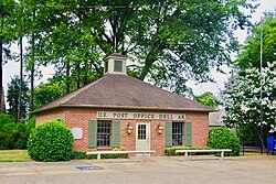
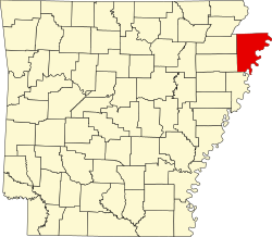
Dell, Arkansas

Last updated

Dell, Arkansas
Town
Town of Dell
Dell-Post-Office-ar.jpg
Post office in Dell
Mississippi County Arkansas Incorporated and Unincorporated areas Dell Highlighted 0518160.svg
Location in Mississippi County, Arkansas
Coordinates: 35°51′26″N90°02′03″W / 35.85722°N 90.03417°W / 35.85722; -90.03417
CountryUnited States
State Arkansas
County Mississippi
Area
[1]
  Total0.92 sq mi (2.38 km2)
  Land0.92 sq mi (2.38 km2)
  Water0.00 sq mi (0.00 km2)
Elevation
[2]
240 ft (70 m)
Population
 (2020) [3]
  Total194
  Density210.64/sq mi (81.37/km2)
Time zone UTC-6 (Central (CST))
  Summer (DST) UTC-5 (CDT)
ZIP code
72426
Area code 870
FIPS code 05-18160
GNIS feature ID2406372 [2]

Dell is a town in Mississippi County, Arkansas, United States. The population was 194 at the 2020 census. [3]

Contents

History

Dell has its origins in a community that developed around a loading dock and post office operated by J.B. Richardson in the late 1890s. When the Jonesboro, Lake City and Eastern Railroad completed a rail line through the area, a town was laid out near the tracks. The town was initially known as "Rozell" after an early landowner, but due to naming conflicts with a nearby community known as "Rochelle", the name was changed to "Dell". The town incorporated in 1905. [4]

Geography

Dell is located in northern Mississippi County. The town lies along the Pemiscot Bayou 9 miles (14 km) southwest of Blytheville, the largest city in the county, and 10 miles (16 km) south of the Arkansas-Missouri state line. Arkansas Highway 18 passes through Dell, connecting the town with Blytheville to the northeast and Manila 8 miles (13 km) to the west. Arkansas Highway 181 intersects AR 14 in Dell, connecting the town with Gosnell 11 miles (18 km) to the northeast and Keiser 15 miles (24 km) to the south.

According to the United States Census Bureau, the town of Dell has a total area of 0.92 square miles (2.38 km2), all land. [1]

Demographics

Historical population
CensusPop.Note
1910 162
1920 23343.8%
1930 26714.6%
1940 32321.0%
1950 38418.9%
1960 383−0.3%
1970 358−6.5%
1980 310−13.4%
1990 258−16.8%
2000 251−2.7%
2010 223−11.2%
2020 194−13.0%
U.S. Decennial Census [5]
2014 Estimate [6]

As of the 2010 United States Census, there were 223 people living in the town. The racial makeup of the town was 99.6% White and 0.4% were Hispanic or Latino of any race.

As of the census [7] of 2000, there were 251 people, 115 households, and 73 families living in the town. The population density was 108.9/km2 (282.5/mi2). There were 121 housing units at an average density of 52.5/km2 (136.2/mi2). The racial makeup of the town was 89.64% White, 1.20% Black or African American, 0.40% Asian, 7.97% from other races, and 0.80% from two or more races. 7.97% of the population were Hispanic or Latino of any race.

There were 115 households, out of which 18.3% had children under the age of 18 living with them, 48.7% were married couples living together, 12.2% had a female householder with no husband present, and 35.7% were non-families. 34.8% of all households were made up of individuals, and 19.1% had someone living alone who was 65 years of age or older. The average household size was 2.18 and the average family size was 2.78.

In the town, the population was spread out, with 19.5% under the age of 18, 10.8% from 18 to 24, 23.1% from 25 to 44, 23.1% from 45 to 64, and 23.5% who were 65 years of age or older. The median age was 43 years. For every 100 females, there were 90.2 males. For every 100 females age 18 and over, there were 88.8 males.

The median income for a household in the town was $26,607, and the median income for a family was $31,667. Males had a median income of $26,250 versus $21,250 for females. The per capita income for the town was $15,762. About 10.6% of families and 12.1% of the population were below the poverty line, including 13.3% of those under the age of eighteen and 12.0% of those 65 or over.

Education

It is served by the Gosnell School District, [8] including Gosnell Elementary School and Gosnell High School. [9]

The community was served by the Dell School District until July 1, 1984, when it merged into the Gosnell School District. [10]

Related Research Articles

<span class="mw-page-title-main">Mississippi County, Arkansas</span> County in Arkansas, United States

Mississippi County is the easternmost county in the U.S. state of Arkansas. As of the 2020 census, the population was 40,685. There are two county seats, Blytheville and Osceola. The county is named for the Mississippi River which borders the county to the east. Mississippi County is part of the First Congressional District in Arkansas.

<span class="mw-page-title-main">Whelen Springs, Arkansas</span> Town in Arkansas, United States

Whelen Springs is a town in Clark County, Arkansas, United States. The population was 92 at the 2010 census. From 1930 through 1939 the town thrived, being a main hub of operations for the then powerful Ozan Lumber Company.

<span class="mw-page-title-main">Nimmons, Arkansas</span> Town in Arkansas, United States

Nimmons is a town in Clay County, Arkansas, United States. The population was 69 at the 2010 census, down from 100 in 2000.

<span class="mw-page-title-main">Crawfordsville, Arkansas</span> Town in Arkansas, United States

Crawfordsville, historically Crawfordville, is a town in Crittenden County, Arkansas, United States. The population was 479 at the 2010 census.

<span class="mw-page-title-main">Edmondson, Arkansas</span> Town in Arkansas, United States

Edmondson is a town in Crittenden County, Arkansas, United States. The population was 427 at the 2010 census.

<span class="mw-page-title-main">Horseshoe Lake, Arkansas</span> Town in Arkansas, United States

Horseshoe Lake is a town in Crittenden County, Arkansas, United States. The population was 264 at the 2020 census.

<span class="mw-page-title-main">Tull, Arkansas</span> Town in Arkansas, United States

Tull is a town in Grant County, Arkansas, United States. The population was 448 at the 2010 census, up from 358 in 2000. It is part of the Central Arkansas region.

<span class="mw-page-title-main">LaGrange, Arkansas</span> Town in Arkansas, United States

LaGrange is a town in Lee County, Arkansas, United States. The population was 89 at the 2010 census, down from 122 at the 2000 census.

<span class="mw-page-title-main">Morrison Bluff, Arkansas</span> Town in Arkansas, United States

Morrison Bluff is a town in Logan County, Arkansas, United States. The population was 64 at the 2010 census and an estimated 81 in 2017.

<span class="mw-page-title-main">Coy, Arkansas</span> Town in Arkansas, United States

Coy is a town in southern Lonoke County, Arkansas, United States. The population was 96 at the 2010 census, making it the smallest incorporated community within the Little Rock–North Little Rock–Conway Metropolitan Statistical Area, as well as one of the smallest in the state.

<span class="mw-page-title-main">Hindsville, Arkansas</span> Town in Arkansas, United States

Hindsville is a town in Madison County, Arkansas, United States. The population was 90 at the 2020 census. It is part of the Northwest Arkansas region.

<span class="mw-page-title-main">Bassett, Arkansas</span> Town in Arkansas, United States

Bassett is a town in Mississippi County, Arkansas, United States. The population was 124 at the 2020 census, down from 173 in 2010.

<span class="mw-page-title-main">Birdsong, Arkansas</span> Town in Arkansas, United States

Birdsong is a town in Mississippi County, Arkansas, United States. The population was 32 at the 2020 census, down from 41 in 2010.

<span class="mw-page-title-main">Blytheville, Arkansas</span> City in Arkansas, United States

Blytheville is the county seat and the largest city in Mississippi County, Arkansas, United States. It is approximately 60 miles (100 km) north of West Memphis. The population was 13,406 at the 2020 census, down from 15,620 in 2010.

<span class="mw-page-title-main">Burdette, Arkansas</span> Town in Arkansas, United States

Burdette is a town in Mississippi County, Arkansas, United States. The population was 140 at the 2020 census, down from 191 in 2010.

<span class="mw-page-title-main">Etowah, Arkansas</span> Town in Arkansas, United States

Etowah is a town in Mississippi County, Arkansas, United States. The population was 254 at the 2020 census, down from 351 in 2010.

<span class="mw-page-title-main">Gosnell, Arkansas</span> City in Arkansas, United States

Gosnell is a city in northern Mississippi County, Arkansas, United States. The population was 2,910 at the 2020 census, down from 3,548 at the 2010 census.

<span class="mw-page-title-main">Luxora, Arkansas</span> City in Arkansas, United States

Luxora is a city in Mississippi County, Arkansas, United States. The population was 942 at the 2020 census, down from 1,178 in 2010.

<span class="mw-page-title-main">Marie, Arkansas</span> Town in Arkansas, United States

Marie is a town in Mississippi County, Arkansas, United States. It was founded by the R.E.L. Wilson cotton company. The population was 108 at the 2020 census.

<span class="mw-page-title-main">Victoria, Arkansas</span> Town in Arkansas, United States

Victoria is a town in Mississippi County, Arkansas, United States. The population was 20 as of the 2020 census, down from 37 in 2010. It is named after a sister of the town's founder, Robert E. Lee Wilson.

References

  1. 1 2 "2021 U.S. Gazetteer Files: Arkansas". United States Census Bureau. Retrieved June 21, 2022.
  2. 1 2 U.S. Geological Survey Geographic Names Information System: Dell, Arkansas
  3. 1 2 "P1. Race – Dell town, Arkansas: 2020 DEC Redistricting Data (PL 94-171)". U.S. Census Bureau. Retrieved June 21, 2022.
  4. Steven Teske, "Dell (Mississippi County)," Encyclopedia of Arkansas History and Culture, 2016.
  5. "Census of Population and Housing". Census.gov. Retrieved June 4, 2015.
  6. "Annual Estimates of the Resident Population for Incorporated Places: April 1, 2010 to July 1, 2014". Archived from the original on May 22, 2015. Retrieved June 4, 2015.
  7. "U.S. Census website". United States Census Bureau . Retrieved January 31, 2008.
  8. "2020 CENSUS - SCHOOL DISTRICT REFERENCE MAP: Mississippi County, AR" (PDF). 2020 U.S. Census . U.S. Census Bureau . Retrieved September 20, 2022. - 2010 Map
  9. "Schools - Town of Dell Arkansas". townofdell.com.
  10. "ConsolidationAnnex_from_1983.xls." Arkansas Department of Education. Retrieved on October 13, 2017.