Aslackby and Laughton

Last updated

Aslackby and Laughton
St.James' church, Aslackby, Lincs. - geograph.org.uk - 90690.jpg
St James' Church, Aslackby
Lincolnshire UK location map.svg
Red pog.svg
Aslackby and Laughton
Location within Lincolnshire
Population251 (2011)
OS grid reference TF083305
  London 95 mi (153 km)  S
Civil parish
  • Aslackby and Laughton
District
Shire county
Region
Country England
Sovereign state United Kingdom
Post town Sleaford
Postcode district NG34
Police Lincolnshire
Fire Lincolnshire
Ambulance East Midlands
UK Parliament
List of places
UK
England
Lincolnshire
52°51′25″N0°24′32″W / 52.857°N 0.409°W / 52.857; -0.409
Parish boundary within Lincolnshire Aslackby and Laughton Lincolnshire UK parish map.svg
Parish boundary within Lincolnshire

Aslackby and Laughton is a civil parish [1] in the South Kesteven district of Lincolnshire, England. According to the 2001 census the parish had a population of 243, [1] in 102 households. [2] increasing slightly to 251 in 118 households at the 2011 census. [3] It consists of the village of Aslackby, the hamlet of Laughton, and scattered farms, [4] and part of the hamlet of Graby.

Contents

Map all coordinates using: OpenStreetMap

Aslackby

Aslackby( /ˈzəlbi/ AY-zəl-bee; 52°51′35″N0°23′20″W / 52.85972°N 0.38889°W / 52.85972; -0.38889 (Aslackby) ) is a small village extending westwards from the A15 road between Rippingale and Folkingham, about halfway between Sleaford and Bourne.

Aslackby Grade I listed Anglican church is dedicated to St James. [5] The chancel is Early English, largely rebuilt 1856, with the tower and nave, Perpendicular. [6] [7] The ecclesiastical parish is Aslackby, part of The Billingborough Group of the Lafford Deanery [8]

There is a dining club, The Templars, for long-term residents, and a local history society. [1]

History

The Aveland, a moat said to be the meeting place for the Wapentake of Aveland is in the parish. [9] There is documentary evidence for a settlement called Avethorpe, from the Domesday survey onwards, but no actual location is known. [10]

Laughton

The hamlet of Laughton ( 52°52′20″N0°23′58″W / 52.87222°N 0.39944°W / 52.87222; -0.39944 (Laughton) ) lies less than 1 mile (1.6 km) to the north of Aslackby. West Laughton at its south-west is the site of a deserted medieval village (DMV). [11] [12] [13]

Lincolnshire preceptories

Until their disbandment in 1312, the Knights Templar were major landowners on the higher lands of Lincolnshire, where they had a number of preceptories on property which provided income, while Temple Bruer was an estate on the Lincoln Heath, believed to have been used also for military training. [14] The preceptories from which the Lincolnshire properties were managed were: [15]

Related Research Articles

<span class="mw-page-title-main">Temple Bruer Preceptory</span> Historic building in Lincolnshire, England

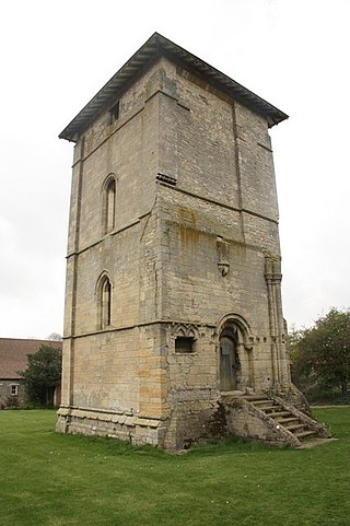
Temple Bruer Preceptory is a historic building in the civil parish of Temple Bruer with Temple High Grange, North Kesteven, Lincolnshire, England. It is one of the few Knights Templar sites left in England where any ruins remain standing. Its name comes from its Templar ownership and its position in the middle of the Lincoln Heath, bruyère (heather) from the French language current at the time. It was founded in the period 1150 to 1160 and the order was dissolved in 1312. The site is located between the A15 and A607 roads, 2.5 miles (4.0 km) north from Cranwell. The site has been excavated twice, firstly by the Rev Dr. G. Oliver, the rector of Scopwick in 1832–3, and in 1908 by Sir William St John Hope.

<span class="mw-page-title-main">Byard's Leap</span> Hamlet in the North Kesteven district of Lincolnshire, England

Byard's Leap is a hamlet in the North Kesteven district of Lincolnshire, England. It is situated approximately 3 miles (5 km) west from Cranwell, and is part of the civil parish of Cranwell, Brauncewell and Byard's Leap. The hamlet is associated with various legends.

<span class="mw-page-title-main">Eagle, Lincolnshire</span> Village in the North Kesteven district of Lincolnshire, England

Eagle is a village in the North Kesteven district of Lincolnshire, England. It is situated 7 miles (11 km) south-west from Lincoln and 2 miles (3.2 km) east from North Scarle. Eagle is part of the civil parish of Eagle and Swinethorpe. The population of the civil parish taken at the 2011 census was 793.

<span class="mw-page-title-main">Bottesford Preceptory</span> Community of the Knights Templar in Lindsey, England

Bottesford Preceptory was sited at Bottesford, just to the south of Scunthorpe, in Lindsey, England. It was on low-lying land, near the Bottesford Beck, about 3 miles (5 km) to the west of the escarpment of the Lincoln Cliff limestone upland, and about the same distance to the east of the River Trent. A preceptory was a community of the Knights Templar who lived on one of that order's estates in the charge of its preceptor. A preceptory also referred to the estate and its buildings. The present Bottesford Manor is believed to have been the gatehouse to the preceptory.

<span class="mw-page-title-main">Aslackby Preceptory</span> Historic site in The Temple Farm

Aslackby Preceptory in Lincolnshire lay to the south-east of Aslackby Church. Until about 1891 a tower, possibly of the preceptory church, together with a vaulted undercroft, survived as part the Temple farmhouse. Temple farmhouse was subsequently rebuilt and a 15th-century window and a stone pinnacle remain in the garden

<span class="mw-page-title-main">Dowsby</span> Village and civil parish in the South Kesteven district of Lincolnshire, England

Dowsby is a village and civil parish in the South Kesteven district of Lincolnshire, England. It is situated on the western edge of The Fens at the junction of the east–west B1397 road and the north–south B1177. It is 1 mile (1.6 km) north-east from Rippingale and just south of Pointon. The civil parish includes the hamlet of Graby. Nearby to the east, along the B1397 at Dowsby Fen, is Car Dyke. The civil parish population taken at the 2011 census was 204.

<span class="mw-page-title-main">Aveland</span> Ancient subdivision of Lincolnshire, England

Aveland was a Wapentake of Kesteven from the time of the Danelaw until the Local Government Act 1888. Its meeting place was The Aveland at grid reference TF 0675 2961 in the parish of Aslackby.

<span class="mw-page-title-main">Aunsby and Dembleby</span> Civil parish in the North Kesteven district of Lincolnshire, England

Aunsby and Dembleby is a civil parish in the North Kesteven district of Lincolnshire, England. According to the 2001 Census it had a population of 125. The parish includes Aunsby and Dembleby, which were separate parishes until 1931, and the hamlet of Scott Willoughby.

<span class="mw-page-title-main">Billingborough</span> Village and civil parish in the South Kesteven district of Lincolnshire, England

Billingborough is a village and civil parish in the South Kesteven district of Lincolnshire, England. It is situated approximately 10 miles (16 km) north of Bourne and 10 miles south of Sleaford, and on the B1177 between Horbling and Pointon just south of the A52.

<span class="mw-page-title-main">Bottesford, Lincolnshire</span> Town in North Lincolnshire, England

Bottesford is a town in North Lincolnshire, Lincolnshire, England.

<span class="mw-page-title-main">South Witham</span> Village and civil parish in the South Kesteven district of Lincolnshire, England

South Witham is a village and civil parish in the South Kesteven district of Lincolnshire, England. The population of the civil parish at the 2011 census was 1,533. It is situated 10 miles (16 km) south of Grantham, 10 miles east of Melton Mowbray and 10 miles (16 km) north of Oakham. The village is close to the Leicestershire and Rutland borders.

<span class="mw-page-title-main">Willoughton</span> Village and civil parish in the West Lindsey district of Lincolnshire, England

Willoughton is a village and civil parish in the West Lindsey district of Lincolnshire, England. It is situated 2 miles (3.2 km) west from the A15 road, 13 miles (21 km) north from Lincoln and 3 miles (5 km) south from Kirton Lindsey. According to the 2001 Census the village had a population of 330, increasing to 341 at the 2011 census.

Great Limber Preceptory, Limber Magna was a Camera (farm) of the Knights Templar and later the Knights Hospitaller in the village of Great Limber, Lincolnshire, England.

Horkstow Camera was a monastic cell in Lincolnshire, England, dependent on Willoughton Preceptory, a house of the Knights Templar.

<span class="mw-page-title-main">Willoughton Preceptory</span> Historic site in Temple Garth

Willoughton Preceptory was a holding of the Knights Templar in Lincolnshire, England. The preceptory stood at the farm, still called Temple Garth.

<span class="mw-page-title-main">Horkstow</span> Village and civil parish in North Lincolnshire, England

Horkstow is a village and civil parish in North Lincolnshire, England, 4 miles (6.4 km) south-west from Barton-upon-Humber, 1 mile (1.6 km) south from South Ferriby and 9 miles (14.5 km) north from Brigg. It lies on the B1204, and 1 mile (1.6 km) east from the navigable River Ancholme. It is one of the five "Low Villages" – Worlaby, Bonby, Saxby All Saints, Horkstow and South Ferriby – between Brigg and the Humber estuary, so-called because of their position below the northern edge of the Lincolnshire Wolds. Horkstow was previously part of Glanford administrative district, and before that, the North Lindsey division of Lindsey, Lincolnshire.

<span class="mw-page-title-main">Great Limber</span> Village and civil parish in the West Lindsey district of Lincolnshire, England

Great Limber is a village and civil parish in the West Lindsey district of Lincolnshire, England. The population of the civil parish at the 2011 census was 271. It is on the A18, 8 miles (13 km) west from Grimsby and 8 miles east from Brigg.

<span class="mw-page-title-main">Witham Preceptory</span> Historic site in Temple Hill

Withham Preceptory, one of the smallest Knights Templar preceptories in England, was founded, before 1164, at Temple Hill, near South Witham, Lincolnshire, and was abandoned in the early 14th century. The site of the former preceptory at Temple Hill, South Witham. It 'has been largely under pasture' since the Knights Templar left in 1308.

<span class="mw-page-title-main">St James' Church, Aslackby</span> Church in England

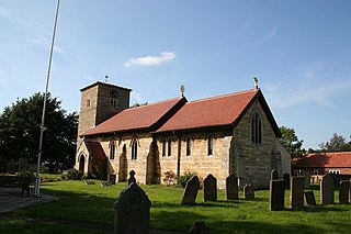
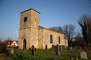
St James the Great Church is a Grade I listed Church of England parish church dedicated to James, son of Zebedee in Aslackby, Lincolnshire, England. The church is 7 miles (11 km) north from Bourne, and in the Aslackby and Laughton parish on the eastern edge the South Kesteven Lincolnshire Vales.

References

  1. 1 2 3 "Civil Parish details".
  2. "2001 census". Neighbourhood Statistics. Office for National Statistics. Archived from the original on 4 March 2016. Retrieved 20 April 2013.
  3. "Civil parish population 2011". Neighbourhood Statistics. Office for National Statistics. Retrieved 21 April 2016.
  4. "Parish Boundary map from SKDC".[ permanent dead link ]
  5. Historic England. "Church of St James (1062757)". National Heritage List for England . Retrieved 9 July 2011.
  6. "Church web site".[ dead link ]
  7. Historic England. "Church (348722)". Research records (formerly PastScape). Retrieved 11 April 2010.
  8. "Aslackby P C C". Archived from the original on 16 July 2011., Diocese of Lincoln
  9. Historic England. "The Aveland moat (348358)". Research records (formerly PastScape). Retrieved 4 July 2010.
  10. Historic England. "National Monument record for Avethorpe (348363)". Research records (formerly PastScape). Retrieved 4 July 2010.
  11. Bourne & Heckington: Billingborough & Morton (Map) (3 ed.). 1:25000. OS Explorer Map. OSGB. 2006. p. 248. ISBN   978-0-319-23811-0 . Retrieved 9 April 2010. West Laughton TF074311
  12. Historic England. "West Laughton (348714)". Research records (formerly PastScape). Retrieved 11 April 2010.
  13. Historic England. "Additional settlement at Laughton (1041290)". Research records (formerly PastScape). Retrieved 11 April 2010.
  14. Ward, Penny (5 December 2023). Dennis Mills (ed.). The Knights Templar in Kesteven (2nd ed.). Heckington: Heritage Lincolnshire Publications. ISBN   978-0-948639-47-0.
  15. Page, William, ed. (1906). "Houses of Knights Templars: Willoughton, Eagle, Aslackby, South Witham and Temple Bruer". A History of the County of Lincoln. Victoria County History. Vol. 2. pp. 210–213. Retrieved 12 February 2011.