
Satellite temperature measurements are inferences of the temperature of the atmosphere at various altitudes as well as sea and land surface temperatures obtained from radiometric measurements by satellites. These measurements can be used to locate weather fronts, monitor the El Niño-Southern Oscillation, determine the strength of tropical cyclones, study urban heat islands and monitor the global climate. Wildfires, volcanos, and industrial hot spots can also be found via thermal imaging from weather satellites.

Envisat is a large Earth-observing satellite which has been inactive since 2012. It is still in orbit and considered space debris. Operated by the European Space Agency (ESA), it was the world's largest civilian Earth observation satellite.

The atmosphere of Earth is the layer of gases, known collectively as air, retained by Earth's gravity that surrounds the planet and forms its planetary atmosphere. The atmosphere of Earth creates pressure, absorbs most meteoroids and ultraviolet solar radiation, warms the surface through heat retention, allowing life and liquid water to exist on the Earth's surface, and reduces temperature extremes between day and night.

STS-66 was a Space Shuttle program mission that was flown by the Space Shuttle Atlantis. STS-66 launched on November 3, 1994, at 11:59:43.060 am EDT from Launch Pad 39-B at NASA's Kennedy Space Center. Atlantis landed at Edwards Air Force Base on November 14, 1994, at 10:33:45 am EST.
SCISAT-1 is a Canadian satellite designed to make observations of the Earth's atmosphere. Its main instruments are an optical Fourier transform infrared spectrometer, the ACE-FTS Instrument, and an ultraviolet spectrophotometer, MAESTRO. These devices record spectra of the Sun, as sunlight passes through the Earth's atmosphere, making analyses of the chemical elements of the atmosphere possible.

The Upper Atmosphere Research Satellite (UARS) was a NASA-operated orbital observatory whose mission was to study the Earth's atmosphere, particularly the protective ozone layer. The 5,900-kilogram (13,000 lb) satellite was deployed from Space Shuttle Discovery during the STS-48 mission on 15 September 1991. It entered Earth orbit at an operational altitude of 600 kilometers (370 mi), with an orbital inclination of 57 degrees.

The TIMED mission is dedicated to study the influences energetics and dynamics of the Sun and humans on the least explored and understood region of Earth's atmosphere – the Mesosphere and Lower Thermosphere / Ionosphere (MLTI). The mission was launched from Vandenberg Air Force Base in California on 7 December 2001 aboard a Delta II rocket launch vehicle. The project is sponsored and managed by NASA, while the spacecraft was designed and assembled by the Applied Physics Laboratory at Johns Hopkins University. The mission has been extended several times, and has now collected data over an entire solar cycle, which helps in its goal to differentiate the Sun's effects on the atmosphere from other effects. It shared its Delta II launch vehicle with the Jason-1 oceanography mission.
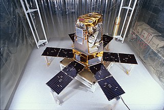
The Solar Radiation and Climate Experiment (SORCE) was a NASA-sponsored satellite mission that measured incoming X-ray, ultraviolet, visible, near-infrared, and total solar radiation. These measurements specifically addressed long-term climate change, natural variability, atmospheric ozone, and UV-B radiation, enhancing climate prediction. These measurements are critical to studies of the Sun, its effect on the Earth's system, and its influence on humankind. SORCE was launched on 25 January 2003 on a Pegasus XL launch vehicle to provide NASA's Earth Science Enterprise (ESE) with precise measurements of solar radiation.

The Dobson spectrophotometer, also known as Dobsonmeter, Dobson spectrometer, or just Dobson is one of the earliest instruments used to measure atmospheric ozone.

The Solar Mesosphere Explorer was a NASA spacecraft to investigate the processes that create and destroy ozone in Earth's upper of the atmosphere of Earth. The mesosphere is a layer of the atmosphere extending from the top of the stratosphere to an altitude of about 80 km (50 mi). The spacecraft carried five instruments to measure ozone, water vapor, and incoming solar radiation.

The Solar Backscatter Ultraviolet Radiometer, or SBUV/2, is a series of operational remote sensors on NOAA weather satellites in Sun-synchronous orbits which have been providing global measurements of stratospheric total ozone, as well as ozone profiles, since March 1985. The SBUV/2 instruments were developed from the SBUV experiment flown on the Nimbus-7 spacecraft which improved on the design of the original BUV instrument on Nimbus-4. These are nadir viewing radiometric instruments operating at mid to near UV wavelengths. SBUV/2 data sets overlap with data from SBUV and TOMS instruments on the Nimbus-7 spacecraft. These extensive data sets measure the density and vertical distribution of ozone in the Earth's atmosphere from six to 30 miles.
The Stratospheric Aerosol and Gas Experiment (SAGE) is a series of remote sensing satellite instruments used to study the chemical composition of Earth's atmosphere. Specifically, SAGE has been used to study the Earth's ozone layer and aerosols at the troposphere through the stratosphere. The SAGE instruments use solar occultation measurement technique to determine chemical concentrations in the atmosphere. Solar occultation measurement technique measures sunlight through the atmosphere and ratios that measurement with a sunlight measurement without atmospheric attenuation. This is achieved by observing sunrises and sunsets during a satellite orbit. Physically, the SAGE instruments measure ultraviolet/visible energy and this is converted via algorithms to determine chemical concentrations. SAGE data has been used to study the atmospheres aerosols, ozone, water vapor, and other trace gases.

Greenhouse gas monitoring is the direct measurement of greenhouse gas emissions and levels. There are several different methods of measuring carbon dioxide concentrations in the atmosphere, including infrared analyzing and manometry. Methane and nitrous oxide are measured by other instruments. Greenhouse gases are measured from space such as by the Orbiting Carbon Observatory and networks of ground stations such as the Integrated Carbon Observation System.

ADEOS I was an Earth observation satellite launched by NASDA in 1996. The mission's Japanese name, Midori means "green". The mission ended in July 1997 after the satellite sustained structural damage to the solar panel. Its successor, ADEOS II, was launched in 2002. Like the first mission, it ended after less than a year, also following solar panel malfunctions.

Atmospheric temperature is a measure of temperature at different levels of the Earth's atmosphere. It is governed by many factors, including incoming solar radiation, humidity and altitude. When discussing surface air temperature, the annual atmospheric temperature range at any geographical location depends largely upon the type of biome, as measured by the Köppen climate classification. The abbreviation MAAT is often used for Mean Annual Air Temperature of a geographical location.

SAGE III on ISS is the fourth generation of a series of NASA Earth-observing instruments, known as the Stratospheric Aerosol and Gas Experiment. The first SAGE III instrument was launched on a Russian Meteor-3M satellite. The recently revised SAGE III was mounted to the International Space Station where it uses the unique vantage point of ISS to make long-term measurements of ozone, aerosols, water vapor, and other gases in Earth's atmosphere.
OSIRIS is an instrument that measures vertical profiles of spectrally dispersed, limb scattered sunlight from the upper troposphere into the lower mesosphere. OSIRIS is one of two instruments on the Odin satellite, launched February, 2001 into a Sun-synchronous, 6 pm/6 am local time orbit at 600 km. This restricts OSIRIS sunlit observations to the Northern hemisphere in May, June, July and August, and the Southern hemisphere in November, December, January and February. Global coverage from 82°S to 82°N occurs on the months adjoining the equinoxes. OSIRIS measurements began November, 2001 and continue to the present.

Meteor-3M No.1 was the first and only of the Meteor-3M series polar-orbiting weather satellites. It was launched on 10 December 2001 at 17:18:57 UTC from the Baikonur Cosmodrome in Kazakhstan. The satellite is in a Sun-synchronous orbit with an ascending node time of about 9AM.
Explorer 55, also called as AE-E, was a NASA scientific satellite belonging to series Atmosphere Explorer, being launched on 20 November 1975 from Cape Canaveral Air Force Station (CCAFS) board a Thor-Delta 2910 launch vehicle.

Explorer 60, also called as SAGE and was the second of the Applications Explorer Missions (AEM), AEM-B, was a NASA scientific satellite launched on 18 February 1979, from Wallops Flight Facility (WFF) by a Scout D-1 launch vehicle.
