
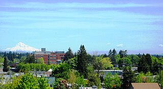
Beaverton is a city in Washington County, in the U.S. state of Oregon with a small portion bordering Portland in the Tualatin Valley. The city is among the main cities that make up the Portland metropolitan area. Its population was 97,494 at the 2020 census, making it the second-largest city in the county and the seventh-largest city in Oregon. Beaverton is an economic center for Washington County along with neighboring Hillsboro. It is home to the world headquarters of Nike, Inc., although it sits outside of city limits on unincorporated county land.
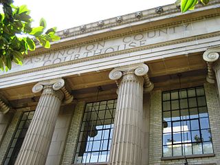
Washington County is one of 36 counties in the U.S. state of Oregon and part of the Portland metropolitan area. The 2020 census recorded the population as 600,372, making it the second most populous county in the state and most populous "Washington County" in the United States. Hillsboro is the county seat and largest city, while other major cities include Beaverton, Tigard, Cornelius, Banks, Gaston, Sherwood, North Plains, and Forest Grove, the county's oldest city. Originally named Twality when created in 1843, the Oregon Territorial Legislature renamed it for the nation's first president in 1849 and included the entire northwest corner of Oregon before new counties were created in 1854. The Tualatin River and its drainage basin lie almost entirely within the county, which shares its boundaries with the Tualatin Valley. It is bordered on the west and north by the Northern Oregon Coast Range, on the south by the Chehalem Mountains, and on the north and east by the Tualatin Mountains, or West Hills.

Cedar Hills is a census-designated place and neighborhood in Washington County, Oregon, United States south of U.S. Route 26 and west of Oregon Route 217 and within the Portland metropolitan area. Constructed starting in 1946, Cedar Hills was the largest single housing tract development in the western United States at the time of its completion in 1961.

Cedar Mill is a suburb in the Portland, Oregon metropolitan area of the United States; it is a census-designated place and an unincorporated community in Washington County, north of U.S. Route 26 and west of the Willamette Stone. It received its name from a sawmill on Cedar Mill Creek, which cut Western Redcedars that were once the dominant tree in the area. The mill's pond was near the intersection of 119th and Cornell Road, and could still be seen into the 1960s, although the mill itself had ceased operating in 1891. The name was established in 1874 with the opening of a U.S. post office named Cedar Mill. As of the 2010 census, the community population was 14,546.
Hillsboro is the fifth-largest city in the U.S. state of Oregon and is the county seat of Washington County. Situated in the Tualatin Valley on the west side of the Portland metropolitan area, the city hosts many high-technology companies, such as Intel, locally known as the Silicon Forest. At the 2020 census, the city's population was 106,447.

Oak Hills is a census-designated place (CDP) and neighborhood in Washington County, Oregon, United States. The CDP population was 9,050 at the 2000 census. It is on unincorporated land north of Beaverton, west of Cedar Mill, and south/southeast of Bethany. The CDP is roughly bounded by the Sunset Highway on the south, West Union Road on the north, Northwest 174th Avenue on the west, and Northwest 143rd Avenue on the east. The U.S. Postal Service has assigned Beaverton addresses to the area. Fire protection and EMS services are provided through Tualatin Valley Fire and Rescue.

Tualatin is a city located primarily in Washington County in the U.S. state of Oregon. A small portion of the city is also located in neighboring Clackamas County. It is a southwestern suburb in the Portland Metropolitan Area that is located south of Tigard. The population was 27,942 at the 2020 census.
The Beaverton School District is a school district in and around Beaverton, Oregon, United States. It serves students throughout Beaverton, Hillsboro, Aloha, and unincorporated neighborhoods of Portland, OR. The Beaverton Elementary School District 48 was established in 1876, with other elementary districts later merged into the district. The elementary district was later merged with the high school district (10J) to create a unified school district. It is the third-largest school district in the state, with an enrollment of 39,180 students as of 2022. For the 2021–2022 school year the district had a total budget of $622.8 million.

The Oregon Electric Railway (OE) was an interurban railroad line in the U.S. state of Oregon that linked Portland to Eugene. Service from Portland to Salem began in January 1908. The Spokane, Portland and Seattle Railway purchased the system in 1910, and extended service to Eugene in 1912. Regular passenger service in the Willamette Valley ended in May 1933. Freight operations continued and the railway survived into the 1990s, ultimately as a Burlington Northern feeder. Operation as an electric railroad ended July 10, 1945.

The Tualatin Valley is a farming and suburban region southwest of Portland, Oregon. The valley is formed by the meandering Tualatin River, a tributary of the Willamette River at the northwest corner of the Willamette Valley, east of the Northern Oregon Coast Range. Most of the valley is located within Washington County, separated from Portland by the Tualatin Mountains. Communities in the Tualatin Valley include Banks, Forest Grove, Cornelius, Hillsboro, Aloha, Beaverton, Sherwood, Tigard, and Tualatin.

The Old Scotch Church, also known as the Tualatin Plains Presbyterian Church, is a church and national historic site located in an unincorporated part of Washington County, Oregon, near Hillsboro, Oregon, United States. The church dates to 1873 while the church structure with an eight-sided steeple dates to 1878. A cemetery on the church grounds holds the graves of church members and local pioneer settlers of the Tualatin Plains, including Joseph Meek.
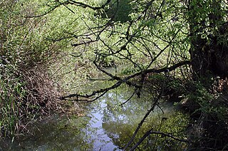
Fanno Creek is a 15-mile (24 km) tributary of the Tualatin River in the U.S. state of Oregon. Part of the drainage basin of the Columbia River, its watershed covers about 32 square miles (83 km2) in Multnomah, Washington, and Clackamas counties, including about 7 square miles (18 km2) within the Portland city limits.

The John Quincy Adams and Elizabeth Young House, also known as the John Quincy Adams Young House, is a historic American saltbox house built in 1869 in the U.S. state of Oregon. It is located in the unincorporated Cedar Mill area of Washington County, Oregon, near Portland, and is listed on the National Register of Historic Places.

Cooper Mountain Nature Park is a 231 acres (93 ha) nature park in the Portland metropolitan area in the U.S. state of Oregon. Opened in 2009, the park is owned and operated by Metro, the regional government in the Oregon portion of the metro area. The park is named after Cooper Mountain, the primary geological feature in the area near Beaverton. Maintained by the regional Tualatin Hills Park and Recreation District, the natural area has 3.5 miles (5.6 km) of hiking trails. It is one of THPRD's two nature parks, along with the Tualatin Hills Nature Park.
Tualatin Hills Park & Recreation District (THPRD) is a special parks district located in the eastern part of Washington County in the U.S. state of Oregon. Created in 1955, the district covers all of the city of Beaverton and many of those communities surrounding Beaverton in the Portland metropolitan area. The district covers an area of 50 square miles (130 km2) and serves a population of about 220,000, making it the largest parks district in Oregon. Tualatin Hills operates over 200 facilities totaling 2,100 acres (850 ha), including eight swimming centers. The district has an annual budget of $40 million and is overseen by a five-person board of directors.

The Belle Ainsworth Jenkins Estate, located near Beaverton, Oregon, United States, is listed on the National Register of Historic Places. Built starting in 1912, the main house on the property was intended as a summer home. The entire 68-acre (28 ha) estate is owned by the Tualatin Hills Park & Recreation District (THPRD). The estate has eight buildings, including the main home and a farmhouse built in 1880.

Tualatin Valley Fire & Rescue (TVF&R) is a special-purpose government fire fighting and emergency services district in the Portland metropolitan area of Oregon. Established in 1989 with a merger between Washington County Fire District 1 and the Tualatin Rural Fire Protection District, it primarily provides fire and emergency medical services in eastern Washington County, but also provides services in neighboring Multnomah, Clackamas, and Yamhill counties. It serves unincorporated areas along with the cities of Beaverton, Tigard, Tualatin, West Linn, Wilsonville, and Sherwood, among others. With over 400 firefighters and 27 fire stations, the district is the second largest fire department in the state and has an annual budget of $197 million.

The Tualatin Hills Nature Park is a 222-acre nature park and wildlife preserve in Beaverton, Oregon, owned by the Tualatin Hills Park & Recreation District (THPRD). It is one of THPRD's two nature parks along with Cooper Mountain Nature Park. The park features 5 miles (8 km) of trails, of which 1.5 miles are paved and 3.5 miles unpaved. The park features a diverse environment including several types of both evergreen and deciduous trees as well as creeks, wetlands, ponds, and meadows. Located on 15655 S.W. Millikan Way, at the main entrance to the park, is the Tualatin Hills Nature Center, formerly called the Tualatin Hills Nature Park Interpretive Center. The name was changed in November 2014. Nature supervisor Kristin Atman said that "six words is really a mouthful" and the new name would be more consistent with THPRD's other facilities.

The Howard M. Terpenning Recreation Complex, often called the Terpenning Recreation Complex or simply the THPRD recreation complex, is a 92-acre recreation complex in Beaverton, Oregon. It is owned and operated by the Tualatin Hills Park and Recreation District (THPRD) and serves as the location of the district's administrative offices. The complex, in addition to the administrative offices, houses an indoor Olympic swimming pool, a tennis center, an athletic center, and several sports fields, as well as a natural area. Approximately 650,000 people visit the complex every year.


