Related Research Articles

The Gulf of St. Lawrence is the outlet of the North American Great Lakes via the St. Lawrence River into the Atlantic Ocean. The gulf is a semi-enclosed sea, covering an area of about 226,000 square kilometres (87,000 sq mi) and containing about 34,500 cubic kilometres (8,300 cu mi) of water, which results in an average depth of 152 metres (499 ft).
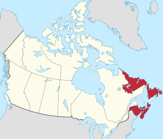
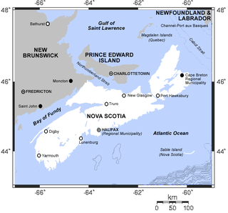
Atlantic Canada, also called the Atlantic provinces, is the region of Eastern Canada comprising the four provinces located on the Atlantic coast, excluding Quebec: the three Maritime Provinces – New Brunswick, Nova Scotia, and Prince Edward Island – and the easternmost province of Newfoundland and Labrador. The population of the four Atlantic provinces in 2016 was about 2,300,000 on half a million km2. The provinces combined had an approximate GDP of $121.888 billion in 2011. The term Atlantic Canada was popularized following the admission of Newfoundland as a Canadian province in 1949.

The Northumberland Strait is a strait in the southern part of the Gulf of Saint Lawrence in eastern Canada. The strait is formed by Prince Edward Island and the gulf's eastern, southern, and western shores.

Machias Seal Island is an island in disputed water between the Gulf of Maine and the Bay of Fundy, about 16 km (10 mi) southeast from Cutler, Maine, and 19 km (12 mi) southwest of Grand Manan Island, New Brunswick. Sovereignty of the island is disputed by the United States and Canada. The Canadian Coast Guard continues to staff a lighthouse on the island; the first lighthouse was constructed there in 1832.

Peggy's Cove is a small rural community located on the eastern shore of St. Margarets Bay in the Halifax Regional Municipality, which is the site of Peggys Cove Lighthouse.

Brier Island is an island in the Bay of Fundy in Digby County, Nova Scotia.
Williams Lake is the name of several places:

Ecum Secum is a rural community on the Eastern Shore of Nova Scotia, Canada, located in both the Halifax Regional Municipality and Guysborough County. Located along the shores of Ecum Secum Harbour, an inlet of the Atlantic Ocean, the community is located roughly 46 km (29 mi) east of Sheet Harbour, Nova Scotia, 37 km (23 mi) southwest of Sherbrooke, Nova Scotia, and approximately 160 km (99 mi) east of Downtown Halifax along the Marine Drive on Trunk 7. Several communities along the western shore of the harbour also share the name, including Ecum Secum Bridge and Ecum Secum West. The name of the community is derived from the Mi'kmaq language and means "a red house". The first Europeans to settle in the Ecum Secum area were Loyalists during the 1780s.
Beaver Harbour is a rural community on the Eastern Shore of Nova Scotia, Canada, in the Halifax Regional Municipality. It is located on the Marine Drive, along Trunk 7 approximately 11 km (6.8 mi) east of Sheet Harbour, Nova Scotia. The community is located on the shores of Beaver Harbour, an inlet of the Atlantic Ocean. The mi'kmaq name for the area was Kobelawakwemoode, translating to "beaver harbour". First Nations legends relay that a large rock in the harbour was thrown by Glooscap, a powerful figure in the First Nations' legends, at the mystical beaver. The land on which the community resides was part of a five thousand acre grant given to a surveyor on July 13, 1773. Five families lived here by the 1830s, and a post office was established in the community on October 1, 1887. A Trans-Atlantic cable station is located in the community, for the former CANTAT-2 cable.

The New England Seamounts is a chain of over twenty underwater extinct volcanic mountains known as seamounts. This chain is located off the coast of Massachusetts in the Atlantic Ocean and extends over 1,000 km from the edge of Georges Bank. Many of the peaks of these mountains rise over 4,000 m from the seabed. The New England Seamounts chain is the longest such chain in the North Atlantic and is home to a diverse range of deep sea fauna. Scientists have visited the chain on various occasions to survey the geologic makeup and biota of the region. The chain is part of the Great Meteor hotspot track and was formed by the movement of the North American Plate over the New England hotspot. The oldest volcanoes that were formed by the same hotspot are northwest of Hudson Bay, Canada. Part of the seamount chain is protected by Northeast Canyons and Seamounts Marine National Monument.

The yellowtail flounder, also known as the rusty dab or simply flounder, is a species of flatfish in the family Pleuronectidae. Reaching 56 cm (22 in) in length, it has reddish brown upperparts, pale underparts and yellow fins. Both its eyes are on the right (upper) side of its body. Found in the western North Atlantic, it has been fished commercially by North American fisheries for food. A victim of overfishing, the yellowtail flounder is categorized as "Vulnerable" by the International Union for Conservation of Nature.

Theodore Too is a large-scale imitation tugboat built in Dayspring, Nova Scotia in 2000 based on the fictional television tugboat character Theodore Tugboat. Theodore Too was located in Bedford, Nova Scotia but arrived in Hamilton, Ontario, his new home, on July 18, 2021.

St. Shott's is the southernmost town in the Canadian province of Newfoundland and Labrador. A popular claim the town is associated with is having the most fog. In the Canada 2016 Census, the town had a population of 66.
Watt Section is a rural community on the Eastern Shore of Nova Scotia, Canada, in the Halifax Regional Municipality. The community is located along Nova Scotia Trunk 7 on the Marine Drive, and is located about 5 km (3.1 mi) southeast of Sheet Harbour, Nova Scotia. The community is located along the eastern side of Sheet Harbour, an inlet of the Atlantic Ocean. The community is named for William Watt, who purchased the land at the present day location of the community in 1844. The cookhouse used at the lumber mill at the head of East River in Sheet Harbour was bought by the residents of Watt Section after the closing of the mill in January 1891, and it was floated down to the community.
Moosehead is a rural community on the Eastern Shore of Nova Scotia, Canada, in the Halifax Regional Municipality.
Murphy Cove is a community on the Eastern Shore of Nova Scotia, Canada, in the Halifax Regional Municipality. The community is located on the Marine Drive on Nova Scotia Trunk 7, about 31 km (19 mi) west of Sheet Harbour, Nova Scotia. The community is named for Thomas Murphy, an Irish settler. The community is situated on the shores of Shoal Bay, an inlet of the Atlantic Ocean. Settlement in the area began in the 1830s.
There are various Black Lakes in Nova Scotia, Canada. They vary widely in size, depth and usability. Many counties, such as Cumberland, Halifax, Inverness, and Pictou Counties have more than one Black Lake so named, while other counties mentioned in this article have only one named Black Lake.

The Digby Gut is a narrow channel connecting the Bay of Fundy with the Annapolis Basin. The town of Digby, Nova Scotia is located on the inner portion of the western side of the Gut. The eastern entrance is marked by the Point Prim Lighthouse. Strong tidal currents, numerous rocky ledges, frequent fogs and unpredictable winds make it a dangerous passage requiring a pilot or local knowledge. Tide flows create 5 knot tidal currents and create numerous whirlpools and eddies. The gut is about a half nautical mile in width and bordered by high rocky cliffs. It marks a break in the North Mountain ridge along the Annapolis Valley and is the eastern end of Digby Neck. Digby Gut had its origins as the northern terminus of the ancient Bear River, part of which is now a drowned river valley.
References
- ↑ "Banquereau". Geographical Names Data Base. Natural Resources Canada . Retrieved 2021-10-25.
- ↑ "Misaine and Banquereau Banks". Canada-Nova Scotia Offshore Petroleum Board (CNSOPB). 2019-03-07. Retrieved 2021-10-25.
- ↑ Banquereau at GEOnet Names Server
- ↑ "Marine Regions · Banquereau (Bank)". Marine Regions. Retrieved 2021-10-25.
- ↑ LeBlanc-Smith, Yvonne (June 15, 2016). "Louisbourg Seafoods wants a chunk of Arctic surf clam fishery". CBC News.

