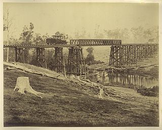
Gowrie Junction is a rural locality in the Toowoomba Region, Queensland, Australia. It is north-west of Toowoomba. The town of Gowrie is in the eastern part of the locality. In the 2021 census, Gowrie Junction had a population of 2,242 people.
Marinna is a locality in Junee Shire in southern New South Wales, Australia. Its main feature is a grain silo on the Main South railway line. A station was opened in the locality between 1897 and 1975.
Whyte Yarcowie is a town and a locality in the Australian state of South Australia. It is on the Barrier Highway between Hallett and Terowie.

Paruna is a township in eastern South Australia on the Browns Well Highway, where it crosses the former Barmera railway line, 237 kilometres (147 mi) east of the state capital, Adelaide.

Gunalda is a rural town in the Gympie Region and a locality split between Gympie Region and Fraser Coast Region in Queensland, Australia. In the 2021 census, the locality of Gunalda had a population of 426 people.
Feysville is an abandoned town in the Goldfields-Esperance region of Western Australia. It is situated between Kalgoorlie and Kambalda just off the Goldfields Highway.

Royalla is a rural locality on the border of New South Wales and the Australian Capital Territory in Australia. The area takes its name from the nearby Mount Rob Roy, and was originally a railway settlement on the Bombala railway line known as Rob Roy and changed to the current name in 1905. Modern Royalla is a large rural locality east of the Monaro Highway. The border with the ACT follows the western boundary of the easement of the former railway line to the east of the highway. The town was served by a railway station until 1975. The NSW part of Royalla had a population of 984 at the 2016 census.

Kagaru is a rural locality split between Scenic Rim Region and City of Logan, Queensland, Australia. In the 2021 census, Kagaru had a population of 19 people.
Kurumbul is a rural town and locality in the Goondiwindi Region, Queensland, Australia. It is on the border of Queensland and New South Wales. In the 2021 census, the locality of Kurumbul had a population of 36 people.

Eubenangee is a coastal locality split between the Cairns Region and the Cassowary Coast Region, Queensland, Australia. In the 2021 census, Eubenangee had a population of 247 people.

Thane is a rural town and locality in the Southern Downs Region, Queensland, Australia. In the 2021 census, the locality of Thane had a population of 19 people.

Kinbombi is a rural town and locality in the Gympie Region, Queensland, Australia. In the 2021 census, the locality of Kinbombi had a population of 34 people.

Manyung is a rural town in the Gympie Region with the locality split between the Gympie Region and the South Burnett Region, Queensland, Australia. In the 2021 census, Manyung had a population of 83 people.
Fletcher is a rural locality in the Southern Downs Region, Queensland, Australia. In the 2021 census, Fletcher had a population of 128 people.

Fleurbaix is a locality in the Southern Downs Region, Queensland, Australia. In the 2021 census, Fleurbaix had a population of 56 people.
Dirnbir is a rural locality in the North Burnett Region, Queensland, Australia. In the 2021 census, Dirnbir had a population of 59 people.
Morwincha is a rural locality in the Scenic Rim Region, Queensland, Australia. In the 2021 census, Morwincha had a population of 35 people.

Grahams Creek is a rural locality in the Fraser Coast Region, Queensland, Australia. In the 2021 census, Grahams Creek had a population of 149 people.
Kings Siding is a rural locality in the Toowoomba Region, Queensland, Australia. In the 2021 census, Kings Siding had a population of 15 people.
Willamulka is a locality at the top of Yorke Peninsula in South Australia. It is on the road between Kadina and Bute. Its name is derived from an Aboriginal word meaning "shiny green stone".


