
Spiritwood is a town in the boreal forest of central Saskatchewan, Canada with a population of approximately 1,000. Its location is 125 km west of Prince Albert and about 110 km northeast of North Battleford at the junction of Highway 3, Highway 24 and Highway 376. As the largest community in the region, the community functions as the major supply, service, and administrative headquarters for the trading area population which includes several First Nation reserves including Witchekan Lake, Big River and Pelican Lake.

Rosthern-Shellbrook is a provincial electoral district for the Legislative Assembly of Saskatchewan, Canada. This constituency was created by the Representation Act, 2002 (Saskatchewan) out of the districts of Rosthern, Shellbrook-Spiritwood, and Redberry Lake.
Division No. 16 is one of eighteen census divisions in the province of Saskatchewan, Canada, as defined by Statistics Canada. It is located in the north-central part of the province. The most populous community in this division is North Battleford.
The Rural Municipality of Canwood No. 494 was firstly formed as Rural Municipality (RM) Thompson No. 494 from January 1, 1913 until April 29, 1916 before changing names to Canwood No. 494. It is located in the north central region of the province of Saskatchewan, west of Prince Albert, and completely surrounds the First Nations Indian Reserve of Ahtahkakoop No. 104, as well as partially surrounding the First Nations Indian Reserve of Mistawasis No. 183 and the RM of Big River No. 118.
The Rural Municipality of Shell Lake No. 495 is a former rural municipality (RM) in Saskatchewan. It was originally formed as the RM of Shell River No. 495 before changing its name to the RM of Shell Lake No. 495 on November 30, 1935. Shell Lake No. 495 was dissolved on December 31, 1953. It was absorbed by the RM of Spiritwood No. 496. It originally comprised nine townships.
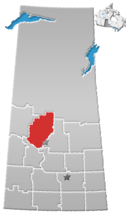
The Rural Municipality of Spiritwood No. 496, Saskatchewan, first formed as Rural Municipality on December 9, 1929 as a 3 township by 3 township R.M. One township is 6 miles by 6 miles square. On December 31, 1953, Spiritwood No. 496 expanded and absorbed Shell Lake No. 495 It is located in the north central region of the province of Saskatchewan, west of Prince Albert. Witchekan Lake First Nation Indian Reserve 117B and Pelican Lake First Nation Indian Reserve 191B both are within this Rural Municipality.
Shell Lake is a village in the boreal forest of central Saskatchewan, Canada. Its location is in the Rural Municipality of Spiritwood No. 496. This village is ninety kilometers west of Prince Albert and has 175 residents in 2016. It was formerly part of the Rural Municipality of Shell Lake No. 495, Saskatchewan before it was absorbed in the RM of Spiritwood. The Shell Lake murders took place on a nearby farm. It is the administrative headquarters of the Ahtahkakoop Cree First Nation band government.
Baljennie is an unincorporated community in Glenside Rural Municipality No. 377, Saskatchewan, Canada. Its first post office opened in 1891.
Big River is a town located on the southern end of Cowan Lake in north central Saskatchewan, Canada. It is just north of Saskatchewan's extensive grain belt on Highway 55 and about sixteen kilometres west of Prince Albert National Park. Delaronde Lake is accessed east of the town. Big River is approximately 132 kilometres to Prince Albert.

Borden is a village within the Rural Municipality of Great Bend No. 405, Saskatchewan, Canada. Borden is named after Sir Frederick William Borden, Minister of Militia in the Laurier Cabinet. An abandoned arch bridge of the same name is located to the southeast and once carried Highway 16 across the North Saskatchewan River.
Leoville is a village within the rural municipality of Spiritwood No. 496, in the province of Saskatchewan, Canada. The village is located along Highway 24. Highway 946 begins in the village and proceeds north. Leoville is home to the administrative headquarters of the Pelican Lake First Nation band government. Leoville had a population of 375 in the 2016 Canadian Census,.
Stenen is a village in the Canadian province of Saskatchewan.
Beaver Creek is a hamlet in the Rural Municipality of Dundurn No. 314, Saskatchewan, Canada. Listed as a designated place by Statistics Canada, the hamlet had a population of 107 in the Canada 2016 Census.
Chortitz is a hamlet in Coulee Rural Municipality No. 136, Saskatchewan, Canada. Listed as a designated place by Statistics Canada, the hamlet had a population of 26 in the Canada 2006 Census. The hamlet is located on Highway 379, about 25 km south of Swift Current.

Wymark is a hamlet in Swift Current Rural Municipality No. 137, Saskatchewan, Canada. Listed as a designated place by Statistics Canada, the hamlet had a population of 144 in the Canada 2006 Census. The hamlet is located on Highway 628 about 2 km north of Highway 363, about 15 km south of Swift Current.
Rabbit Lake is a special service area within the Rural Municipality of Round Hill No. 467 in Saskatchewan, Canada. It dissolved from village status on October 30, 2015. It originally incorporated as a village on April 13, 1928. The population was 113 at the 2006 Canada Census a substantial 29.9% increase from the 2001 Canada Census.
Burnham is an unincorporated community in Coulee Rural Municipality No. 136, Saskatchewan, Canada. The community is located on Highway 628, approximately 9 km (5.6 mi) north of Highway 363 and 15 km (9.3 mi) south of Swift Current.
Braddock is an unincorporated community in Coulee Rural Municipality No. 136, Saskatchewan, Canada. The community is located on Highway 721, about 35 km (22 mi) southeast of Swift Current.
Shellbrook was a provincial electoral district for the Legislative Assembly of the province of Saskatchewan, Canada, in the area of Shellbrook, Saskatchewan, west of Prince Albert.

Feudal is a hamlet in Perdue No. 346, Saskatchewan, Canada. The hamlet is located at the junction of Highway 655 and Township road 340 approximately 15 km north of the Village of Harris.
