Batchawana Bay, Ontario

Last updated
Batchawana Bay
Batchawana Bay ON.JPG
Etymology: Badjiwanung Ojibwe for "water that bubbles up"
Canada Ontario location map 2.svg
Red pog.svg
Batchawana Bay
Location in Ontario
Coordinates: 46°55′34″N84°36′23″W / 46.92611°N 84.60639°W / 46.92611; -84.60639 Coordinates: 46°55′34″N84°36′23″W / 46.92611°N 84.60639°W / 46.92611; -84.60639 [1]
Country Canada
Province Ontario
District Algoma
Time zone UTC-5 (Eastern Time Zone)
  Summer (DST) UTC-4 (Eastern Time Zone)
Postal code
P0S 1A0
Area codes 705, 249

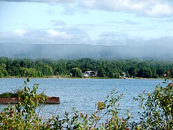
Batchawana Bay is an unincorporated place and Compact Rural Community in Algoma District in Northeastern Ontario, Canada. [1] [2] [3] [4] It is also the name of a local services board, consisting of parts of the geographic townships of Fisher, Herrick, Ryan and Tilley. [5] It is located north of Sault Ste. Marie, Ontario, on the shores of Batchawana Bay [6] off Lake Superior.

The area is counted as part of Unorganized North Algoma District in Statistics Canada census data.

Batchawana Bay Provincial Park is nearby along Highway 17; [7] [8] the community itself is reached from Highway 17 by Ontario Highway 563.

See also

Related Research Articles

<span class="mw-page-title-main">Restoule</span> Designated place with Local Services Board in Ontario, Canada

Restoule is a community and designated place in geographic Patterson Township in the Centre Unorganized Part of Parry Sound District in Central Ontario, Canada. It is situated on the Restoule River between Commanda Lake, and Restoule Lake and is part of the Almaguin Highlands region.

Batchawana River River in Ontario, Canada

The Batchawana River is a river in Algoma and Sudbury Districts of Ontario, Canada, which empties into Batchawana Bay on Lake Superior north of Sault Ste. Marie, Ontario.

Kaladar Compact rural communityUnincorporated area in Ontario, Canada

Kaladar is a compact rural community and unincorporated area in the municipality of Addington Highlands, Lennox and Addington County in Eastern Ontario, Canada. It is located at the junction of Ontario Highway 7 and Ontario Highway 41.

<span class="mw-page-title-main">Batchawana Bay</span> Body of water

Batchawana Bay is a small bay in Algoma District in Northeastern Ontario, Canada. It is on the eastern shore of Lake Superior, approximately 50 kilometres (31 mi) north of Sault Ste. Marie.

<span class="mw-page-title-main">Rossport, Ontario</span> Unincorporated community in Ontario, Canada

Rossport is a dispersed rural community and unincorporated place in the Unorganized part of Thunder Bay District in northwestern Ontario, Canada. It is on the north shore of Lake Superior in geographic Lahontan Township, and is on Ontario Highway 17. Rossport is a designated place served by a local services board, and has a population of 65.

Shabaqua Corners is a dispersed rural community and unincorporated area in geographic Dawson Road Lots Township in the Unorganized Part of Thunder Bay District in Northwestern Ontario, Canada. It is 56 kilometres (35 mi) west of Thunder Bay at the junction of Ontario Highway 17 and Ontario Highway 11; both highways at this point are part of the Trans-Canada Highway. There is an Ontario Provincial Police detachment in the community. The Oskondaga River flows through the community to its mouth at the Shebandowan River just to the south.

Speckled Trout Creek is a creek in geographic Labonte Township, Algoma District in Northeastern Ontario, Canada. It is almost entirely in Lake Superior Provincial Park, is in the Great Lakes Basin, and empties into Lake Superior.

Coppell, Ontario Dispersed rural communityUnincorporated area in Ontario, Canada

Coppell is a dispersed rural community and unincorporated place in geographic Lowther Township, Cochrane District in Northeastern Ontario, Canada. It is about 22 kilometres (14 mi) southwest of Hearst, and is counted as part of Unorganized Cochrane North Part in Canadian census data.

Mead, Ontario Dispersed Rural CommunityUnincorporated area in Ontario, Canada

Mead is a Dispersed Rural Community and unincorporated place in geographic Lowther Township, Cochrane District in Northeastern Ontario, Canada. The community is counted as part of Unorganized Cochrane North Part in Canadian census data, and is located just north of the border with Algoma District.

<span class="mw-page-title-main">Hurkett</span> Dispersed rural community in Ontario, Canada

Hurkett is a dispersed rural community and unincorporated place in the Unorganized part of Thunder Bay District in northwestern Ontario, Canada. It is on Black Bay on the north shore of Lake Superior in geographic Stirling Township, and is on Ontario Highway 582, a short spur off Ontario Highway 17. Hurkett is a designated place served by a local services board, and has a population of 236.

East Gorham is a local services board for the unincorporated geographic townships of Gorham and Jacques in Thunder Bay District, Ontario, Canada.

The Carp River is a river in the Unorganized North Part of Algoma District in Northeastern Ontario, Canada. The river is in the Great Lakes Basin and is a tributary of Lake Superior.

The Little White River is a river in the Unorganized North Part of Algoma District in Northeastern Ontario, Canada. It is in the Great Lakes Basin and is a left tributary of the Mississagi River.

Horsey is a railway point and unincorporated place in geographic Templeton Township, Algoma District in Northeastern Ontario, Canada. The community is counted as part of Unorganized Algoma North Part in Canadian census data, and is located just south of the border with Cochrane District.

Boon is a railway point and unincorporated place in geographic Templeton Township, Algoma District in Northeastern Ontario, Canada. It is counted as part of Unorganized Algoma North Part in Canadian census data.

Hale is a Railway point and unincorporated place in geographic Templeton Township, Algoma District in Northeastern Ontario, Canada. The community is counted as part of Unorganized Algoma North Part in Canadian census data.

The Kashabowie River is a river in southwestern Thunder Bay District in Northwestern Ontario, Canada. It is in the Great Lakes Basin and is a tributary of the Shebandowan Lakes.

The Chapleau River is a river in Algoma District and Sudbury District in northeastern Ontario, Canada. It is in the James Bay drainage basin, begins at Chapleau Lake and is the main tributary of Kapuskasing Lake.

Postans is an unincorporated place and railway point in southwestern Thunder Bay District in Northwestern Ontario, Canada. It is on the Canadian National Railway Kashabowie Subdivision main line, built originally as the Canadian Northern Railway transcontinental main line, and just off Ontario Highway 11, at this point part of the Trans-Canada Highway, in both cases between the community of Kashabowie to the west and the railway point of Kabaigon to the east. Postans is also at the outlet from Postans Lake where an unnamed creek heads west to Postans Bay on Kashabowie Lake, part of the Kashabowie River.

Remi Lake is a lake in both the municipality of Moonbeam and geographic Gurney Township in Unorganized North Cochrane District, Cochrane District, in Northeastern Ontario, Canada. It is in the James Bay drainage basin.

References

  1. 1 2 "Batchawana Bay". Geographical Names Data Base . Natural Resources Canada . Retrieved 2018-07-01. (community)
  2. "CLAIMaps IV". Ontario Ministry of Northern Development and Mines. 2016. Retrieved 2018-07-01.
  3. Map 12 (PDF) (Map). 1 : 1,600,000. Official road map of Ontario. Ministry of Transportation of Ontario. 2016-01-01. Retrieved 2018-07-01.
  4. Restructured municipalities - Ontario map #4 (Map). Restructuring Maps of Ontario. Ontario Ministry of Municipal Affairs and Housing. 2006. Retrieved 2018-07-01.
  5. Local Services Boards, R.R.O. 1990, Reg. 737 Archived 2014-03-10 at the Wayback Machine . Canadian Legal Information Institute.
  6. "Batchawana Bay". Geographical Names Data Base . Natural Resources Canada . Retrieved 2018-07-01. (bay)
  7. "Batchawana Bay Provincial Park". Geographical Names Data Base . Natural Resources Canada . Retrieved 2018-07-01. (park)
  8. "Batchawana Bay". Ontario Parks. Retrieved 2018-07-01.