Bayfront, Wisconsin | |
|---|---|
 Bayfront  Bayfront | |
| Coordinates: 46°37′22″N90°47′37″W / 46.62278°N 90.79361°W | |
| Country | United States |
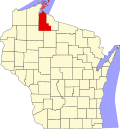
| State | Wisconsin |
| County | Ashland |
| Town | Sanborn |
| Area | |
• Total | 1.42 sq mi (3.69 km2) |
| • Land | 1.42 sq mi (3.69 km2) |
| • Water | 0 sq mi (0.0 km2) |
| Elevation | 625 ft (191 m) |
| Population | |
• Total | 113 |
| Time zone | UTC-6 (Central (CST)) |
| • Summer (DST) | UTC-5 (CDT) |
| ZIP Code | 54806 (Ashland) |
| Area codes | 715/534 |
| FIPS code | 55-05387 |
| GNIS feature ID | 2813409 [3] |
Bayfront is an unincorporated community and census-designated place (CDP) in Ashland County, Wisconsin, United States. As of the 2020 census, it had a population of 113. [2]
Bayfront is in northern Ashland County, on the southeastern shore of Chequamegon Bay, an inlet of Lake Superior. The community is within the limits of the Bad River Reservation. Ashland, the county seat, is 5 miles (8 km) to the southwest.