British Columbia Ferry Services Inc., operating as BC Ferries (BCF), is a former provincial Crown corporation, now operating as an independently managed, publicly owned Canadian company. BC Ferries provides all major passenger and vehicle ferry services for coastal and island communities in the Canadian province of British Columbia. Set up in 1960 to provide a similar service to that provided by the Black Ball Line and the Canadian Pacific Railway, which were affected by job action at the time, BC Ferries has become the largest passenger ferry line in North America, operating a fleet of 41 vessels with a total passenger and crew capacity of over 27,000, serving 47 locations on the B.C. coast.

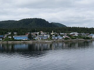
Prince Rupert is a port city in the province of British Columbia, Canada. Its location is on Kaien Island near the Alaskan panhandle. It is the land, air, and water transportation hub of British Columbia's North Coast, and has a population of 12,220 people as of 2016.
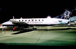
Pacific Coastal Airlines is a Canadian regional airline that operates scheduled, charter and cargo services to destinations in British Columbia. Its head office is located in the South Terminal of Vancouver International Airport in Richmond, British Columbia. Its main base is Vancouver International Airport.
Bella Bella, also known as Waglisla, is the home of the Heiltsuk and is an unincorporated community and Indian reserve community located within Bella Bella Indian Reserve No. 1 on the east coast of Campbell Island in the Central Coast region of British Columbia, Canada. Bella Bella is located 98 nautical miles (181 km) north of Port Hardy, on Vancouver Island, and 78 nautical miles (144 km) west of Bella Coola. The community is on Lama Passage, part of the Inside Passage – a transportation route linking the area, and northern British Columbia as well as Alaska for marine vessels carrying cargo, passengers and recreational boaters from the south coast. The settlement "forms a national capital of sorts" to the Heiltsuk.

North Coast is a provincial electoral district for the Legislative Assembly of British Columbia, Canada. It was created by 1990 legislation which came into effect for the 1991 election, largely out of the previous riding of Prince Rupert.

Port Hardy is a district municipality in British Columbia, Canada located on the north-east end of Vancouver Island. Port Hardy has a population of 3,902 as of the 2021 census.

Bella Coola is a unincorporated community in the Bella Coola Valley of British Columbia, Canada. Bella Coola usually refers to the entire valley, encompassing the settlements of Bella Coola proper, Lower Bella Coola, Hagensborg, Salloompt, Nusatsum, Firvale, and Stuie. It is also the location of the head offices of the Central Coast Regional District.

The British Columbia Coast, popularly referred to as the BC Coast or simply the Coast, is a geographic region of the Canadian province of British Columbia. As the entire western continental coastline of Canada along the Pacific Ocean is in the province, it is synonymous with being the West Coast of Canada.
The Bella Coola River is a major river on the Pacific slope of the Coast Mountains in southern British Columbia. The town of Bella Coola is at its mouth on North Bentinck Arm. Bella Coola Indian Reserve No. 1 the location of the main community today of the surviving population of the Nuxalk who gathered there after depredations by smallpox and colonialization.

MV Queen of the North was a roll-on/roll-off (RORO) ferry built by AG Weser of Germany and operated by BC Ferries, which ran along an 18-hour route along the British Columbia Coast of Canada between Port Hardy and Prince Rupert, British Columbia, a route also known as the Inside Passage. On March 22, 2006, with 101 people aboard, she failed to make a planned course change, ran aground and sank. Two passengers, whose bodies were never found, died in the incident. The ship had a gross register tonnage of 8,806, and an overall length of 125 metres (410 ft). She had a capacity of 700 passengers and 115 cars.
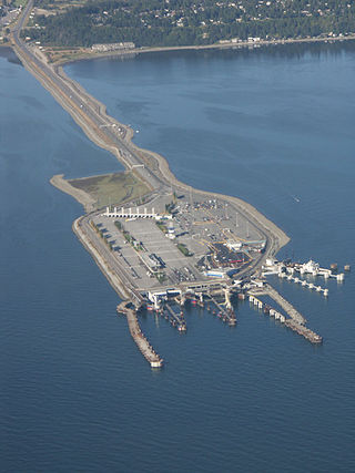
Tsawwassen is a ferry terminal and a major transportation facility in Delta, British Columbia, part of the BC Ferries system and Highway 17. Positioned less than 500 metres (1,600 ft) from the 49th parallel along the Canada–United States border, it is located at the southwestern end of a 2-kilometre (1 mi) causeway that juts out into the Strait of Georgia off the mainland at the community of Tsawwassen. With an approximate size of 23 hectares, it is the largest ferry terminal in North America.

MV Queen of Prince Rupert was a roll-on/roll-off (RORO) ferry operated by BC Ferries that provided the main surface transport link between the Queen Charlotte Islands and mainland British Columbia, connecting Skidegate with Prince Rupert across the Hecate Strait. The vessel also ran on the Prince Rupert–Port Hardy Inside Passage route during the low season.

MV Nimpkish is an N-class ferry formerly owned by BC Ferries. It is 33.93 metres (111.3 ft) long, holds 12 vehicles and 95 passengers, and its maximum speed is 11 knots. Nimpkish entered service with the Ministry of Transportation's Salt Water division in 1973, and was built in Vancouver to serve the inter-island routes. The vessel was transferred to BC Ferries in 1985. It formerly did runs on the Discovery Coast Connector service, a summer-only route linking Port Hardy, Bella Bella, Shearwater, Klemtu, Ocean Falls and Bella Coola.

MV Queen of Chilliwack was a ferry owned by BC Ferries, built in Norway in 1978, then known as Bastø I. The ferry route she was assigned to was the Moss–Horten Ferry in the Oslofjord.

Shearwater is a community in coastal British Columbia. It is located three miles from Old Bella Bella on Denny Island. It is in the territory of the Heiltsuk Nation.

Horseshoe Bay is a major ferry terminal owned and operated by BC Ferries in British Columbia, Canada. Located in the community of Horseshoe Bay, a neighbourhood of West Vancouver, the terminal provides a vehicle ferry link from the Lower Mainland to Vancouver Island, the Sunshine Coast, and to Bowen Island, a small island in the southern part of Howe Sound.
Shushartie is a ghost town on the east shore of Shushartie Bay near the northeastern extremity of Vancouver Island, British Columbia.

Seaforth Channel is a channel in the Central Coast region of the Canadian province of British Columbia which is part of the Inside Passage - the 950 miles (1,530 km) passage between Seattle, Washington and Juneau, Alaska. The marine highway goes through Seaforth Channel on the way to Milbanke Sound, one of the open sea portions of the Inland Passage. Seaforth Channel which is part of the Prince Rupert/Port Hardy BC ferry route, extends in a westerly direction from Denny Island to Milbanke Sound between Denny Island, Campbell Island and the Wright group of islands on the south. In October 2016, a Texas-owned tug/barge transiting the Canadian waters of the Inside Passage without a local pilot was hard grounded on a reef at the entrance to Seaforth Channel in October 2016. More than 100,000 L of fuel contaminated the coast, coves and shores 20 km (12 mi) west of Bella Bella, the core community of the Heiltsuk Nation as well as the environmentally sensitive Great Bear Rainforest - Canada's contribution to the Queen's Commonwealth Canopy (QCC), a network of forest conservation programs. Clean up response and salvage was criticized by the Heiltsuk, B.C. Premier Christy Clark and Prime Minister Justin Trudeau. In November in Vancouver the Prime Minister announced a $1.5B ocean protection plan to "create a marine safety system, restore marine ecosystems and undertake research into oil spill cleanup methods."

Westview is a ferry terminal in Powell River, British Columbia, Canada. It is located on Malaspina Strait, part of the Strait of Georgia, on the northern Sunshine Coast and provides connections to Texada Island and Vancouver Island. The ferry port is connected to Highway 101 via a short access road.
The MV Northern Sea Wolf is a roll-on/roll-off (RORO) ferry operated by BC Ferries in British Columbia, Canada. Her normal sailing schedule is five days a week during the peak summer season on the Inside Passage route connecting Bella Coola and Port Hardy. The route normally takes about ten hours to complete. Her schedule calls for one trip per day during daylight hours to maximize passenger enjoyment of the scenery.Lack of sufficient crew accommodation limits voyage to 12 hours per day precluding travel for indigenous tourism to the outer coast towns without a multiple days or week visit.
