A ferry is a boat that carries passengers, and sometimes vehicles and cargo, across a body of water. A small passenger ferry with many stops, such as in Venice, Italy, is sometimes called a water taxi or water bus.

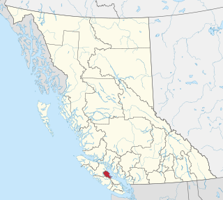
Vancouver Island is an island in the northeastern Pacific Ocean and part of the Canadian province of British Columbia. The island is 456 km (283 mi) in length, 100 km (62 mi) in width at its widest point, and 32,100 km2 (12,400 sq mi) in total area, while 31,285 km2 (12,079 sq mi) are of land. The island is the largest by area and the most populous along the west coasts of the Americas.
British Columbia Ferry Services Inc., operating as BC Ferries (BCF), is a former provincial Crown corporation, now operating as an independently managed, publicly owned Canadian company. BC Ferries provides all major passenger and vehicle ferry services for coastal and island communities in the Canadian province of British Columbia. Set up in 1960 to provide a similar service to that provided by the Black Ball Line and the Canadian Pacific Railway, which were affected by job action at the time, BC Ferries has become the largest passenger ferry line in North America, operating a fleet of 41 vessels with a total passenger and crew capacity of over 27,000, serving 47 locations on the B.C. coast.
Highway 19A, known locally as the Oceanside Route or the Old Island Highway, is a provincial highway in British Columbia, Canada. It runs along two former sections of Highway 19 on Vancouver Island, within Nanaimo and between Craig's Crossing and Campbell River. The section of Highway 19A between Craig's Crossing and Campbell River is 136.89 km (85.06 mi) long, and the Nanaimo alignment covers 10.64 km (6.61 mi). The highway was established after Highway 19 was realigned to a new road between 1996 and 2001.

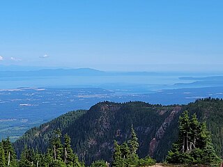
The Strait of Georgia or the Georgia Strait is an arm of the Salish Sea between Vancouver Island and the extreme southwestern mainland coast of British Columbia, Canada, and the extreme northwestern mainland coast of Washington, United States. It is approximately 240 kilometres (150 mi) long and varies in width from 20 to 58 kilometres. Along with the Strait of Juan de Fuca and Puget Sound, it is a constituent part of the Salish Sea.

Powell River is a city on the northern Sunshine Coast of southwestern British Columbia, Canada. Most of its population lives near the eastern shores of Malaspina Strait, which is part of the larger Georgia Strait between Vancouver Island and the Mainland. With two intervening long, steep-sided fjords inhibiting the construction of a contiguous road connection with Vancouver to the south, geographical surroundings explain Powell River's remoteness as a community, despite relative proximity to Vancouver and other populous areas of the BC Coast. The city is the location of the head office of the qathet Regional District.

Courtenay is a city of about 26,000 on the east coast of Vancouver Island, in the Canadian province of British Columbia. It is the largest community and only city in the area commonly known as the Comox Valley, and the seat of the Comox Valley Regional District, which replaced the Comox-Strathcona Regional District. Courtenay is 4 km (2.5 mi) west of the town of Comox, 7 km (4.3 mi) northeast of the village of Cumberland, 5 km (3.1 mi) northwest of the unincorporated settlement of Royston, and 108 km (67 mi) northwest of Nanaimo. Along with Nanaimo and Victoria, it is home to The Canadian Scottish Regiment, a Primary Reserve infantry regiment of the Canadian Armed Forces.
The Comox Valley is a region on the east coast of Vancouver Island, British Columbia, Canada, that includes the city of Courtenay, the town of Comox, the village of Cumberland, and the unincorporated settlements of Royston, Union Bay, Fanny Bay, Black Creek, and Merville. The communities of Denman Island and Hornby Island are also considered part of the Comox Valley. The Comox Valley contains the 47th largest metropolitan area in Canada with a population of about 76,000 as of 2022.
Hornby Island of British Columbia, Canada, is one of the two northernmost Gulf Islands, the other being Denman Island. It is located near Vancouver Island's Comox Valley,
Union Bay is an unincorporated community located south of Hart Creek on the east coast of central Vancouver Island, British Columbia. This Comox Valley community on BC Highway 19A is by road about 93 kilometres (58 mi) north of Nanaimo, and 14 kilometres (9 mi) south of Courtenay.
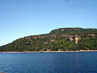
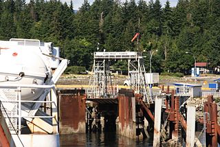
Baynes Sound is the channel between Denman Island and Vancouver Island, British Columbia, Canada. The sound is a narrow western offshoot of the Strait of Georgia that separates Vancouver Island from the mainland of British Columbia. The area is actively harvested by the local oyster industry, as is apparent by an abundance of oyster farms. It produces 39% of the oysters and 55% of the manila clams farmed in British Columbia. The sound is 40 km (25 mi) long and is 3.5 km (2.2 mi) wide at its widest point, although the average width is less than 2 km (1.2 mi). The southern boundary lies around Chrome Island, a small island off Boyle Point, the southern tip of Denman. The northern boundary is less defined, but lies between Tree Island at the northern end of Denman and the Comox harbour. The sound is dotted with the small communities of Royston, Union Bay, Buckley Bay, Mud Bay, Fanny Bay, and Deep Bay on Vancouver Island. The crossing is served by the British Columbia Ferry Services Inc. ship MV Baynes Sound Connector, between Buckley Bay and Denman Island. Baynes Sound is named after British Rear Admiral Robert L. Baynes, who commanded the Pacific Squadron from 1857 to 1860. Baynes Sound is the home of Vancouver Island University Center for Shellfish Research's Deep Bay Marine Field Station.

BC Ferries operates two T-class ferries for use on small inter-island routes. They have raised bows, which make it easier for the ships to travel in the rough seas often found on British Columbia's central coast. The ferries carry 30 cars and 150 passengers. Both were built in 1969. They were originally owned and operated by the British Columbia Ministry of Transportation until 1985, when the Ministry's saltwater ferries and routes were transferred to BC Ferries, including the T class. The two T-class ferries are Tachek and Quadra Queen II.

Buckley Bay is a geographical location on the east coast of Vancouver Island, located between Union Bay to the north and Fanny Bay to the south. It is the departure point for the BC Ferries crossing of Baynes Sound to Denman Island and on to Hornby Island. Buckley Bay is accessible from both the Old Island Highway (19A) and from Exit 101 on the newer Inland Island Highway (19). The Island Rail Corridor also passes through Buckley Bay at Mile 126.2 of the Victoria Subdivision. The area has a population of 173, according to the 2006 Census.

Denman Island,, is one of the Northern Gulf Islands and part of the Comox Valley Regional District of British Columbia, Canada. It is a member of the Islands Trust group of islands and is home to a small community of 1391 year-round residents.

Fanny Bay is an unincorporated community in the Canadian province of British Columbia. It is located on Baynes Sound on the east coast of Vancouver Island. It has a population of 921. It is best known for its fine oysters. The area is served by the Island Highway.
The Comox Valley Regional District is a regional district in British Columbia, Canada. It was created on February 15, 2008, encompassing the southeastern portions of the former Regional District of Comox-Strathcona, and centred about the Comox Valley. The partition left the new Comox Valley Regional District with only 8.4 percent of the former Comox-Strathcona's land area, but 57.9 percent of its population. The CVRD covers an area of 2,425 square kilometres, of which 1,725 square kilometres is land, and serves a population of 72,445 according to the 2023 Census. The district borders the Strathcona Regional District to the northwest, the Alberni-Clayoquot Regional District to the southwest, and the Regional District of Nanaimo to the southeast, as well as the qathet Regional District along the Strait of Georgia to the east.
Little River is a community in the Comox Valley region of Vancouver Island, British Columbia, Canada.

The MV Quinitsa is an automobile ferry operated by BC Ferries. It was built in 1977 by Vancouver Shipyards in Vancouver, British Columbia. The ferry was originally part of the Ministry of Transportation and Highways' (MoT) saltwater ferry fleet until 1985, when the MoT's saltwater ferries—including Quinitsa—were transferred to BC Ferries.

Duke Point is a major ferry terminal owned and operated by BC Ferries that provides ferry service across the Strait of Georgia to Tsawwassen. The ferry terminal is located at Duke Point in Nanaimo and is the only major terminal in the BC Ferries system without a public transit connection.

Westview is a ferry terminal in Powell River, British Columbia, Canada. It is located on Malaspina Strait, part of the Strait of Georgia, on the northern Sunshine Coast and provides connections to Texada Island and Vancouver Island. The ferry port is connected to Highway 101 via a short access road.
