Bedford Charter Township, Michigan

Last updated
Bedford Charter Township, Michigan
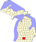
MIMap-doton-Bedford.PNG
Location of Bedford Charter Township in Michigan
Coordinates: 42°22′23″N85°14′18″W / 42.37306°N 85.23833°W / 42.37306; -85.23833
Country United States
State Michigan
County Calhoun
Area
  Total29.7 sq mi (76.9 km2)
  Land29.1 sq mi (75.4 km2)
  Water0.6 sq mi (1.6 km2)
Elevation
866 ft (264 m)
Population
 (2020)
  Total9,198
Time zone UTC-5 (Eastern (EST))
  Summer (DST) UTC-4 (EDT)
ZIP code
49020
Area code 269
FIPS code 26-06720 [1]
GNIS feature ID1625905 [2]
Website bedfordchartertownship.gov

Bedford Charter Township is a charter township located in the northwest corner of Calhoun County in the U.S. state of Michigan. It is part of the Battle Creek, Michigan Metropolitan Statistical Area. As of the 2020 census, the township population was 9,198. [3] Most of the township lies north of the Kalamazoo River and the city of Battle Creek. Three small noncontiguous areas of the township lie south of the Kalamazoo River.

Contents

History

Bedford Township was first organized in 1839. As of 1910 it had a population of 2,076. [4]

Communities

Geography

According to the United States Census Bureau, the township has a total area of 29.7 square miles (76.9 km2), of which 29.1 square miles (75.4 km2) is land and 0.62 square miles (1.6 km2), or 2.03%, is water. [6]

Demographics

Historical population
CensusPop.Note
1960 10,486
1970 10,8173.2%
1980 10,157−6.1%
1990 9,810−3.4%
2000 9,517−3.0%
2010 9,357−1.7%
2020 9,198−1.7%
Source: Census Bureau. Census 1960- 2000, 2010.

As of the census [1] of 2000, there were 9,517 people, 3,667 households, and 2,651 families residing in the township. The population density was 324.0 inhabitants per square mile (125.1/km2). There were 3,841 housing units at an average density of 130.8 per square mile (50.5/km2). The racial makeup of the township was 84.05% White, 12.09% African American, 0.34% Native American, 0.43% Asian, 0.06% Pacific Islander, 0.85% from other races, and 2.18% from two or more races. Hispanic or Latino of any race were 1.49% of the population.

There were 3,667 households, out of which 30.1% had children under the age of 18 living with them, 55.9% were married couples living together, 12.4% had a female householder with no husband present, and 27.7% were non-families. 22.5% of all households were made up of individuals, and 8.9% had someone living alone who was 65 years of age or older. The average household size was 2.52 and the average family size was 2.94.

In the township the population was spread out, with 24.1% under the age of 18, 7.0% from 18 to 24, 26.9% from 25 to 44, 27.4% from 45 to 64, and 14.5% who were 65 years of age or older. The median age was 40 years. For every 100 females, there were 101.8 males. For every 100 females age 18 and over, there were 98.7 males.

The median income for a household in the township was $44,462, and the median income for a family was $51,230. Males had a median income of $37,331 versus $26,435 for females. The per capita income for the township was $20,303. About 4.3% of families and 5.8% of the population were below the poverty line, including 4.5% of those under age 18 and 6.2% of those age 65 or over.

Notable people

Related Research Articles

<span class="mw-page-title-main">Kalamazoo County, Michigan</span> County in Michigan, United States

Kalamazoo County is a county located in the U.S. state of Michigan. As of 2020, the population was 261,670. The county seat is Kalamazoo.

<span class="mw-page-title-main">Calhoun County, Michigan</span> County in Michigan, United States

Calhoun County is a county in the U.S. state of Michigan. As of the 2020 Census, the population was 134,310. The county seat is Marshall. The county was established on October 19, 1829, and named after John C. Calhoun, who was at the time Vice President under Andrew Jackson, making it one of Michigan's Cabinet counties. County government was first organized on March 6, 1833. Calhoun County comprises the Battle Creek Metropolitan Statistical Area and is included in the Kalamazoo-Battle Creek-Portage Combined Statistical Area.

Albion Township is a civil township of Calhoun County in the U.S. state of Michigan. It is part of the Battle Creek, Michigan Metropolitan Statistical Area. As of the 2020 census, the township population was 1,094.

<span class="mw-page-title-main">Brownlee Park, Michigan</span> Census-designated place & unincorporated community in Michigan, United States

Brownlee Park is a census-designated place (CDP) in Calhoun County in the U.S. state of Michigan.The population was 2,021 at the 2020 census. The CDP is immediately east of the city of Battle Creek and is part of the Battle Creek Metropolitan Statistical Area.

Clarence Township is a civil township located in northeast Calhoun County in the U.S. state of Michigan. It is part of the Battle Creek, Michigan Metropolitan Statistical Area. The population was 1,985 at the 2010 census. The township was originally named Pinkney Township.

<span class="mw-page-title-main">Emmett Charter Township, Michigan</span> Charter township in Michigan, United States

Emmett Charter Township is a charter township of Calhoun County in the U.S. state of Michigan. It is part of the Battle Creek Metropolitan Statistical Area. The population was 11,744 at the 2020 census.

Homer Township is a civil township of Calhoun County in the U.S. state of Michigan. It is part of the Battle Creek, Michigan Metropolitan Statistical Area. The population was 3,015 at the 2010 census.

Leroy Township is a civil township of Calhoun County in the U.S. state of Michigan. It is part of the Battle Creek, Michigan Metropolitan Statistical Area. The population was 3,712 at the 2010 census.

<span class="mw-page-title-main">Level Park–Oak Park, Michigan</span> Census-designated place & unincorporated community in Michigan, United States

Level Park–Oak Park is a census-designated place for statistical purposes in Calhoun County in the U.S. state of Michigan. The CDP population was 3,260 at the 2020 census. The CDP is immediately northwest of the city of Battle Creek and is part of the Battle Creek Metropolitan Statistical Area.

Marengo Township is a civil township of Calhoun County in the U.S. state of Michigan. It is part of the Battle Creek, Michigan Metropolitan Statistical Area. As of the 2010 census, the township population was 2,213.

Marshall Township is a civil township of Calhoun County in the U.S. state of Michigan. It is part of the Battle Creek, Michigan Metropolitan Statistical Area. The population was 3,115 at the 2010 census. The city of Marshall is adjacent to the township, but is administratively autonomous.

Pennfield Charter Township is a charter township of Calhoun County in the U.S. state of Michigan. It is part of the Battle Creek, Michigan Metropolitan Statistical Area. The population was 8,781 at the 2020 census.

<span class="mw-page-title-main">Charleston Township, Kalamazoo County, Michigan</span> Civil township in Michigan, United States

Charleston Township is a civil township of Kalamazoo County in the U.S. state of Michigan. The 2010 census recorded a population of 1,975, up from 1,813 at the 2000 census.

<span class="mw-page-title-main">Comstock Township, Michigan</span> Charter township in Michigan, United States

Comstock Charter Township is a charter township of Kalamazoo County in the U.S. state of Michigan, located east of the city of Kalamazoo and is part of the Kalamazoo–Portage Metropolitan Area. The 2010 census recorded the population within the township at 14,854.

<span class="mw-page-title-main">Ross Township, Michigan</span> Civil township in Michigan, United States

Ross Township is a township in Kalamazoo County in the U.S. state of Michigan. The population was 4,664 at the 2010 census, down from 5,047 at the 2000 census.

<span class="mw-page-title-main">South Gull Lake, Michigan</span> Census-designated place & unincorporated community in Michigan, United States

South Gull Lake is a census-designated place (CDP) in Ross Township, Kalamazoo County, in the U.S. state of Michigan. It includes the unincorporated communities of Yorkville, Gull Lake, and Midland Park and does not have any legal status as an incorporated municipality. The population of the CDP was 1,182 at the 2010 census, down from 1,526 at the 2000 census.

<span class="mw-page-title-main">Texas Charter Township, Michigan</span> Charter township in Michigan, United States

Texas Charter Township, officially named the Charter Township of Texas, is a charter township of Kalamazoo County, in the U.S. state of Michigan. As of the 2010 census, the township population was 14,697, up from 10,919 at the 2000 census. It encompasses the entire portion of the survey township T3S R12W.

<span class="mw-page-title-main">Wakeshma Township, Michigan</span> Civil township in Michigan, United States

Wakeshma Township is a civil township of Kalamazoo County in the U.S. state of Michigan. The 2010 census recorded a population of 1,301, down from 1,414 at the 2000 census.

<span class="mw-page-title-main">Kalamazoo–Portage metropolitan area</span> Metropolitan area in Michigan, United States

The Kalamazoo–Portage Metropolitan Area comprises a region surrounding Kalamazoo. 2015 estimates placed it as the 151st largest among similarly designated areas in the United States. 2015 estimates place the combined statistical area 85th among similarly designated areas.

<span class="mw-page-title-main">Battle Creek, Michigan</span> City in Michigan, United States

Battle Creek is a city in the U.S. state of Michigan, in northwest Calhoun County, at the confluence of the Kalamazoo and Battle Creek rivers. It is the principal city of the Battle Creek, Michigan Metropolitan Statistical Area (MSA), which encompasses all of Calhoun County. As of the 2020 census, the city had a total population of 52,731. Nicknamed "Cereal City", it is best known as the home of WK Kellogg Co and the founding city of Post Consumer Brands.

References

  1. 1 2 "U.S. Census website". United States Census Bureau . Retrieved 2008-01-31.
  2. U.S. Geological Survey Geographic Names Information System: Bedford Charter Township, Michigan
  3. "Bedford charter township, Calhoun County, Michigan - Census Bureau Profile". United States Census Bureau. Retrieved 22 March 2024.
  4. Gardner, Washington (1913). History of Calhoun county, Michigan: a narrative account of its historical progress, its people, and its principal interests, Volume 1. Chicago, New York: The Lewis publishing company. pp. 173–175. Retrieved 8 August 2011.
  5. U.S. Geological Survey Geographic Names Information System: Bedford, Michigan
  6. "Geographic Identifiers: 2010 Demographic Profile Data (G001): Bedford charter township, Calhoun County, Michigan". U.S. Census Bureau, American Factfinder. Archived from the original on February 12, 2020. Retrieved August 26, 2014.