Athens, Michigan

Last updated

Athens, Michigan
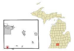
Calhoun County Michigan Incorporated and Unincorporated areas Athens Highlighted.svg
Location of Athens in Calhoun County, Michigan
Coordinates: 42°5′12″N85°14′8″W / 42.08667°N 85.23556°W / 42.08667; -85.23556
Country United States
State Michigan
County Calhoun
Township Athens
Government
Area
[1]
  Total1.01 sq mi (2.62 km2)
  Land1.01 sq mi (2.61 km2)
  Water0.01 sq mi (0.02 km2)
Elevation
889 ft (271 m)
Population
 (2020)
  Total936
  Density929.49/sq mi (358.85/km2)
Time zone UTC-5 (Eastern (EST))
  Summer (DST) UTC-4 (EDT)
ZIP code
49011
Area code 269
FIPS code 26-03880 [2]
GNIS feature ID2398004 [3]

Athens is a village in Calhoun County in the U.S. state of Michigan. The population was 936 at the 2020 census. The village is located in southern Athens Township, and is part of the Battle Creek, Michigan Metropolitan Statistical Area. It was settled in 1831. [4]

Contents

Geography

According to the United States Census Bureau, the village has a total area of 1.02 square miles (2.64 km2), of which 1.01 square miles (2.62 km2) is land and 0.01 square miles (0.03 km2) is water. [5] The Nottawa Creek, also known as the Nottawa River, flows through Athens.

Demographics

Historical population
CensusPop.Note
1880 597
1890 441−26.1%
1900 58332.2%
1910 6318.2%
1920 553−12.4%
1930 62212.5%
1940 6585.8%
1950 76816.7%
1960 96625.8%
1970 9963.1%
1980 960−3.6%
1990 9903.1%
2000 1,11112.2%
2010 1,024−7.8%
2020 936−8.6%
Source: Census Bureau. Census 1960- 2000, 2010.

2010 census

As of the census [6] of 2010, there were 1,024 people, 387 households, and 279 families living in the village. The population density was 1,013.9 inhabitants per square mile (391.5/km2). There were 424 housing units at an average density of 419.8 per square mile (162.1/km2). The racial makeup of the village was 95.4% White, 0.5% African American, 0.9% Native American, 0.1% Asian, 0.1% Pacific Islander, 0.8% from other races, and 2.2% from two or more races. Hispanic or Latino of any race were 1.4% of the population.

There were 387 households, of which 34.6% had children under the age of 18 living with them, 54.3% were married couples living together, 11.4% had a female householder with no husband present, 6.5% had a male householder with no wife present, and 27.9% were non-families. 22.5% of all households were made up of individuals, and 9.8% had someone living alone who was 65 years of age or older. The average household size was 2.65 and the average family size was 3.08.

The median age in the village was 38.9 years. 24% of residents were under the age of 18; 10% were between the ages of 18 and 24; 25% were from 25 to 44; 26.9% were from 45 to 64; and 14.1% were 65 years of age or older. The gender makeup of the village was 50.3% male and 49.7% female.

2000 census

As of the census [2] of 2000, there were 1,111 people, 397 households, and 298 families living in the village. The population density was 1,115.7 inhabitants per square mile (430.8/km2). There were 424 housing units at an average density of 425.8 per square mile (164.4/km2). The racial makeup of the village was 97.48% White, 0.27% African American, 0.81% Native American, 0.27% Pacific Islander, 0.09% from other races, and 1.08% from two or more races. Hispanic or Latino of any race were 1.89% of the population.

There were 397 households, out of which 41.6% had children under the age of 18 living with them, 61.2% were married couples living together, 10.1% had a female householder with no husband present, and 24.7% were non-families. 20.9% of all households were made up of individuals, and 9.3% had someone living alone who was 65 years of age or older. The average household size was 2.80 and the average family size was 3.23.

In the village, the population was spread out, with 32.3% under the age of 18, 7.7% from 18 to 24, 32.3% from 25 to 44, 16.0% from 45 to 64, and 11.6% who were 65 years of age or older. The median age was 32 years. For every 100 females, there were 93.9 males. For every 100 females age 18 and over, there were 90.4 males.

The median income for a household in the village was $42,083, and the median income for a family was $49,375. Males had a median income of $36,618 versus $26,875 for females. The per capita income for the village was $16,409. About 3.7% of families and 5.3% of the population were below the poverty line, including 5.9% of those under age 18 and 6.3% of those age 65 or over.
Related Research Articles

Athens Township is a civil township of southwest Calhoun County in the U.S. state of Michigan, about 15 miles (24 km) south of Battle Creek. It is part of the Battle Creek, Michigan Metropolitan Statistical Area. As of the 2020 census, the township population was 2,444. The Nottawaseppi Huron Band of Potawatomi is based in Athens Township.

<span class="mw-page-title-main">Maple Rapids, Michigan</span> Village in Michigan, United States

Maple Rapids is a village in Clinton County in the U.S. state of Michigan. The population was 672 at the 2010 census. The village is located in Essex Township about 10 miles (16.1 km) northwest of St. Johns. A portion of the village is within the Maple River State Game Area.

<span class="mw-page-title-main">Copper City, Michigan</span> Village in Michigan, United States

Copper City is a village in Houghton County of the U.S. state of Michigan. The population was 187 at the 2020 census. The village is within Calumet Township. With an area of 0.08 square miles (0.21 km2), it is the second-smallest incorporated municipality by area in the state of Michigan after the nearby village of Ahmeek.

<span class="mw-page-title-main">Pigeon, Michigan</span> Village in Michigan, United States

Pigeon is a village in Huron County in the U.S. state of Michigan. The population was 1,208 at the 2010 census. The village is within Winsor Township.

<span class="mw-page-title-main">Webberville, Michigan</span> Village in Michigan, United States

Webberville is a village in Ingham County in the U.S. state of Michigan. It is located within Leroy Township. The population was 1,288 at the 2020 census.

<span class="mw-page-title-main">Lyons, Michigan</span> Village in Michigan, United States

Lyons is a village in Ionia County in the U.S. state of Michigan. The population was 789 at the 2010 census. Most of the village is within Lyons Township. A small portion extends west into Ionia Township.

<span class="mw-page-title-main">Nottawa Township, Isabella County, Michigan</span> Civil township in Michigan, United States

Nottawa Township is a civil township of Isabella County in the U.S. state of Michigan. The population was 2,225 at the 2020 census.

<span class="mw-page-title-main">Sherman Township, Isabella County, Michigan</span> Civil township in Michigan, United States

Sherman Township is a civil township of Isabella County in the U.S. state of Michigan. The population was 2,616 at the 2000 census.

<span class="mw-page-title-main">Weidman, Michigan</span> Census-designated place & unincorporated community in Michigan, United States

Weidman is an unincorporated community in Isabella County, Michigan, United States. It is a census-designated place (CDP) for statistical purposes, but has no independent municipal authority. The population of the CDP was 959 at the 2010 census, up from 879 at the 2000 census.

<span class="mw-page-title-main">Clifford, Michigan</span> Village in Michigan, United States

Clifford is a village in Lapeer County of the U.S. state of Michigan. The population was 324 at the 2010 census. The village is within Burlington Township.

<span class="mw-page-title-main">Clinton, Lenawee County, Michigan</span> Village in Michigan, United States

Clinton is a village in Lenawee County in the Irish Hills area of the U.S. state of Michigan. The population was 2,336 at the 2010 census. The village is located within Clinton Township.

<span class="mw-page-title-main">Applegate, Michigan</span> Village in Michigan, United States

Applegate is a village in Sanilac County of the U.S. state of Michigan. The population was 241 at the 2020 census. Applegate is in the southeast corner of Washington Township on the boundary with Sanilac Township.

<span class="mw-page-title-main">Morrice, Michigan</span> Village in Michigan, United States

Morrice is a village located in Shiawassee County in the U.S. state of Michigan. The population was 927 at the 2010 census. The village is located within Perry Township. The center of population of Michigan is located near Morrice.

<span class="mw-page-title-main">New Lothrop, Michigan</span> Village in Michigan, United States

New Lothrop is a village in Shiawassee County in the U.S. state of Michigan. The population was 565 at the 2020 census. The village is located within Hazelton Township.

Nottawa Township is a civil township of St. Joseph County in the U.S. state of Michigan. The population was 3,999 at the 2000 census. The township is named after the Nottawaseppi Huron Band of Potawatomi.

<span class="mw-page-title-main">Gagetown, Michigan</span> Village in Michigan, United States

Gagetown is a village in Tuscola County in the U.S. state of Michigan. The population was 388 at the 2010 census. It is located in the northeastern corner of Elmwood Township.

<span class="mw-page-title-main">Lawton, Michigan</span> Village in Michigan, United States

Lawton is a village in southeastern Van Buren County, Michigan, United States. The population was 1,900 at the 2010 census.

Leonidas Township is a civil township of St. Joseph County in the U.S. state of Michigan. The population was 1,239 at the 2000 census.

<span class="mw-page-title-main">Trimble, Ohio</span> Village in Ohio, United States

Trimble is a village in Trimble Township, Athens County, Ohio, United States. The population was 329 at the 2020 census.

Lennon is a village in the U.S. state of Michigan. The population was 511 at the 2010 census. The village is located along M-13 within Venice Township in Shiawassee County to the west and Clayton Township in Genesee County to the east.

References

Notes

  1. "2020 U.S. Gazetteer Files". United States Census Bureau. Retrieved May 21, 2022.
  2. 1 2 "U.S. Census website". United States Census Bureau . Retrieved January 31, 2008.
  3. U.S. Geological Survey Geographic Names Information System: Athens, Michigan
  4. Romig 1986, p. 32.
  5. "US Gazetteer files 2010". United States Census Bureau. Archived from the original on January 25, 2012. Retrieved November 25, 2012.
  6. "U.S. Census website". United States Census Bureau . Retrieved November 25, 2012.

Sources