Benton Township, South Dakota | |
|---|---|
 Benton Township | |
| Coordinates: 43°37′51″N96°49′52″W / 43.63083°N 96.83111°W | |
| Country | |
| State | |
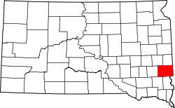
| County | Minnehaha |
| Area | |
• Total | 31.36 sq mi (81.21 km2) |
| • Land | 31.34 sq mi (81.18 km2) |
| • Water | 0.014 sq mi (0.036 km2) |
| Elevation | 1,558 ft (475 m) |
| Population (2020) | |
• Total | 778 |
| • Density | 24.8/sq mi (9.58/km2) |
| Time zone | UTC-6 (Central (CST)) |
| • Summer (DST) | UTC-5 (CDT) |
| Area code | 605 |
| FIPS code | 46-04860 |
| GNIS feature ID | 1267932 [1] |
Benton Township is a township in Minnehaha County, South Dakota, United States. The population was 778 at the 2020 census. [2]